
Today: Scattered showers and thunderstorms, mainly after 4pm. Some of the storms could be severe. Partly sunny, with a high near 84. Breezy, with a light and variable wind becoming south 15 to 20 mph in the morning. Winds could gust as high as 28 mph. Chance of precipitation is 50%. New rainfall amounts between a quarter and half of an inch possible.
Tonight: Showers and thunderstorms, mainly before midnight. Some of the storms could be severe. Low around 45. South wind 9 to 11 mph becoming west southwest in the evening. Chance of precipitation is 80%. New rainfall amounts between a quarter and half of an inch possible.
Saturday: Mostly sunny, with a high near 54. Windy, with a west southwest wind 9 to 14 mph increasing to 18 to 23 mph in the afternoon. Winds could gust as high as 31 mph.
Saturday Night: A 20 percent chance of showers. Mostly cloudy, with a low around 38. West wind 10 to 14 mph, with gusts as high as 18 mph.
Sunday: Partly sunny, with a high near 57. West northwest wind 9 to 14 mph, with gusts as high as 18 mph.
Sunday Night: Mostly clear, with a low around 39.
Monday: Sunny, with a high near 68.
4:39-a.m. CDT 10/4/13
THE NATIONAL WEATHER SERVICE HAS CANCELLED SEVERE THUNDERSTORM WATCH 537 which had been in effect until 5-a.m. today. There are currently no other watches or warnings in effect for the KJAN listening area.
ADAIR-CASS-
408 AM CDT FRI OCT 4 2013
…NICKEL HAIL POSSIBLE…
AT 403 AM CDT…NATIONAL WEATHER SERVICE DOPPLER RADAR INDICATED A STRONG THUNDERSTORM OVER CENTRAL CASS COUNTY…MOVING EAST AT 30 MPH. NICKEL SIZE HAIL…WINDS GREATER THAN 30 MPH…BRIEF MODERATE DOWNPOURS…ARE POSSIBLE WITH THIS STORM.
LOCATIONS IMPACTED INCLUDE…
MASSENA… BRIDGEWATER… GUSTY WINDS MAY CAUSE SMALL OBJECTS SUCH AS TRASH BINS TO BLOW AROUND. SEEK SHELTER IN A STURDY STRUCTURE UNTIL THIS STORM HAS PASSED.
Strong storms that rolled through western Iowa overnight Thursday into early this (Friday) morning, caused damage to trees in Adair and Guthrie Counties. The National Weather Service says Emergency Management officials for the two counties reported that between 1:30-and 1:35-a.m., numerous tree branches ranging from four- to 6-inches in diameter fell in Adair and Guthrie Center, and there were scattered power outages affecting parts of both towns.
Additional damage reports may be forthcoming, once officials get a better look, after sunrise. The Weather Service issued a Severe Thunderstorm Watch for the KJAN listening area at around 8:20-p.m., Thursday. A portion of the Watch area in far west/southwest Iowa was replaced by a Tornado Watch about an hour later. The first severe thunderstorm warnings issued for southwest Iowa came in at around 11:45-p.m., and it affected Mills County. Additional warnings were issued throughout the night, for Montgomery, Pottawattamie, Guthrie and Adair Counties.
THE NATIONAL WEATHER SERVICE HAS CANCELLED TORNADO WATCH 538 FOR
THE FOLLOWING AREAS…
IN IOWA THIS CANCELS 5 COUNTIES: FREMONT MILLS MONTGOMERY PAGE POTTAWATTAMIE
COUNTIES: MILLS -MONTGOMERY -POTTAWATTAMIE 1230 AM CDT FRI OCT 4 2013
…A SEVERE THUNDERSTORM WARNING REMAINS IN EFFECT UNTIL 100 AM CDT FOR NORTHEASTERN MILLS…NORTHERN MONTGOMERY AND EASTERN POTTAWATTAMIE COUNTIES…
AT 1225 AM CDT…SEVERE THUNDERSTORMS WERE LOCATED ALONG A LINE EXTENDING FROM MINDEN TO CARSON TO EMERSON…MOVING NORTHEAST AT 35 MPH.
HAZARD…60 MPH WIND GUSTS.
LOCATIONS IMPACTED INCLUDE…
AVOCA…OAKLAND…WALNUT…CARSON…ELLIOTT…MACEDONIA…HANCOCK…
HENDERSON AND GRANT.
1214 AM CDT FRI OCT 4 2013
THE NATIONAL WEATHER SERVICE IN OMAHA HAS ISSUED A SEVERE THUNDERSTORM WARNING FOR…EASTERN MILLS COUNTY IN SOUTHWEST IOWA…NORTHERN MONTGOMERY COUNTY IN SOUTHWEST IOWA…POTTAWATTAMIE COUNTY IN SOUTHWEST IOWA…
* UNTIL 100 AM CDT
* AT 1211 AM CDT…SEVERE THUNDERSTORMS WERE LOCATED ALONG A LINE EXTENDING FROM 6 MILES SOUTH OF UNDERWOOD TO TREYNOR TO MALVERN…MOVING NORTHEAST AT 40 MPH.
HAZARD…60 MPH WIND GUSTS AND PENNY SIZE HAIL.
SOURCE…RADAR INDICATED.
IMPACT…EXPECT DAMAGE TO ROOFS…SIDING AND TREES.
* LOCATIONS IMPACTED INCLUDE… OAKLAND…AVOCA…MALVERN…TREYNOR…CARSON…WALNUT…SHELBY…
MINDEN…ELLIOTT…MACEDONIA…HANCOCK…HENDERSON…MCCLELLAND…
GRANT…OLD TOWN PARK…FARM CREEK PUBLIC WILDLIFE AREA AND BOTNA
BEND PARK.
PRECAUTIONARY/PREPAREDNESS ACTIONS…
FOR YOUR PROTECTION MOVE TO AN INTERIOR ROOM ON THE LOWEST FLOOR OF A
BUILDING.
A TORNADO WATCH REMAINS IN EFFECT UNTIL 500 AM CDT FRIDAY MORNING
FOR SOUTHWESTERN IOWA AND SOUTHEAST NEBRASKA.
915 PM CDT THU OCT 3 2013
TORNADO WATCH 538 IS IN EFFECT UNTIL 500 AM CDT FRIDAY, FOR THE FOLLOWING LOCATIONS IN IOWA: FREMONT MILLS MONTGOMERY PAGE AND POTTAWATTAMIE COUNTIES.
The National Weather Service at 8:20-p.m. Thursday, issued SEVERE THUNDERSTORM WATCH #537, which is in effect until 5-a.m. Friday. Area Counties included in the SEVERE THUNDERSTORM WATCH: ADAIR ADAMS AUDUBON CARROLL CASS CRAWFORD DALLAS FREMONT HARRISON GUTHRIE MADISON MILLS MONTGOMERY PAGE POTTAWATTAMIE RINGGOLD SAC SHELBY TAYLOR AND UNION.
PRIMARY THREATS INCLUDE…
NUMEROUS LARGE HAIL EVENTS LIKELY WITH A FEW VERY LARGE HAIL EVENTS TO 2.5 INCHES IN DIAMETER POSSIBLE; SEVERAL DAMAGING WIND GUSTS TO 70 MPH POSSIBLE; A FEW TORNADOES POSSIBLE
THE SEVERE THUNDERSTORM WATCH AREA IS APPROXIMATELY ALONG AND 140 STATUTE MILES EAST AND WEST OF A LINE FROM 10 MILES WEST SOUTHWEST OF FALLS CITY NEBRASKA TO 70 MILES NORTH OF DES MOINES, IOWA.
A SEVERE THUNDERSTORM WATCH MEANS CONDITIONS ARE FAVORABLE FOR THE DEVELOPMENT OF SEVERE STORMS IN AND CLOSE TO THE WATCH AREA. PERSONS IN THESE AREAS SHOULD BE ON THE LOOKOUT FOR THREATENING WEATHER CONDITIONS AND LISTEN FOR LATER STATEMENTS AND POSSIBLE WARNINGS. SEVERE THUNDERSTORMS CAN AND OCCASIONALLY DO PRODUCE TORNADOES.
The Iowa Storm Chasing Network (http://iowachase.com) reports the Severe Storm Prediction Center (SPC) is currently watching parts of southwestern Iowa for the probability of issuing a severe thunderstorm watch.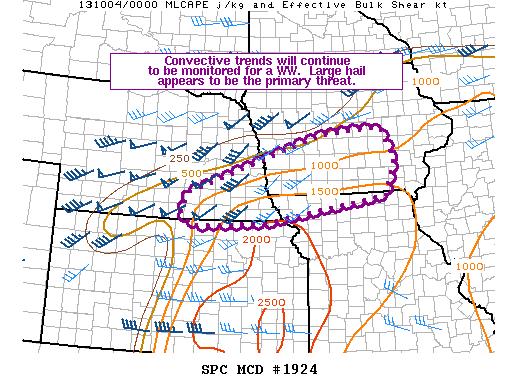 It appears more robust storm initiation will occur over the next hour or two across south central Iowa. A large hail and perhaps an isolated tornado threat may develop over the next several hours as attempts are made for storms to increase in coverage and intensity across central Iowa


