
1153 AM CDT FRI OCT 4 2013
COUNTIES: MONONA-HARRISON-SHELBY-POTTAWATTAMIE-MILLS-MONTGOMERY-FREMONT-PAGE
THIS AFTERNOON AND TONIGHT….
THERE IS A MODERATE RISK FOR SEVERE THUNDERSTORMS OVER PARTS OF EXTREME EASTERN NEBRASKA AND WESTERN IOWA. THERE IS A SLIGHT RISK FOR SEVERE THUNDERSTORMS ACROSS THE REST OF THE OUTLOOK AREA.
THUNDERSTORMS ARE EXPECTED TO INITIALLY DEVELOP IN EASTERN NEBRASKA AFTER 3 PM. THESE THUNDERSTORMS WILL MOVE ACROSS EASTERN NEBRASKA AND INTO WESTERN IOWA THROUGH 7 PM. THE MAIN THREATS INITIALLY FROM THE THUNDERSTORMS WILL BE VERY LARGE HAIL AND DAMAGING WINDS. AS THE LINE OF STORMS PUSHES TOWARD THE MISSOURI RIVER STRONGER INSTABILITY AND WIND SHEAR WILL ENHANCE STORM DEVELOPMENT WITH THE POTENTIAL FOR TORNADO DEVELOPMENT FOR AREAS ALONG THE MISSOURI RIVER INTO WESTERN IOWA.
THE STORMS ARE EXPECTED TO BE FAST MOVING AND PUSH EAST OUT OF THE AREA AFTER 9 PM.
The Iowa Storm Chasing Network says a “Very dangerous situation” could be in the works for this afternoon and this evening, where the development of destructive tornadoes is concerned. The enhanced risk exists over a large portion of Iowa.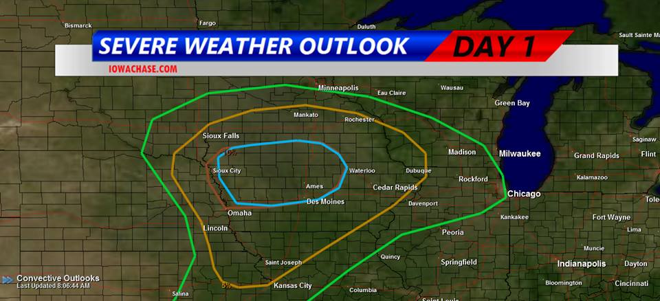
Thunder and lightning awakened many Iowans this morning (Friday) as a potent, large storm system began to bear down on the state. Numerous thunderstorm watches and warnings were issued in the wee hours. Meteorologist Brad Small, at the National Weather Service, says the next several hours will be an active period for weather across much of the state. “The potential is still there for more activity later in the day,” Small says. “There’s a moderate risk of severe weather over northern Iowa and into parts of central Iowa. That would mean all kinds of severe weather, large hail, damaging winds and tornadoes are all possible in that area.” To the west, Small says it’s much less like early fall and much more like the dead of winter as Blizzard Warnings and Winter Storm Watches are in effect in South Dakota, Nebraska, Colorado and Wyoming.
“There’s heavy snow in the Black Hills, thankfully we’ll miss out on that but temperatures will be sharply colder by tomorrow,” Small says. “It’s a big change from what we’ve seen the past few days. Highs will only be in the 50s and 60s.” Iowans can count their blessings as some states to the west have a forecast that includes 12 to 20-inches of snow and strong winds, bringing white-out conditions.
(Radio Iowa/Iowa Storm Chasers Network)
DES MOINES, Iowa (AP) – Strong thunderstorms moving through Iowa are leaving tree branches scattered and in some locations breaking through power lines causing outages. MidAmerican Energy reports 1,640 customers without power with most of them located in the Des Moines area but dozens in Council Bluffs and Sioux City. Alliant Energy says it has 350 customers out mostly around Boone. No injuries have been reported.
The storms packed winds estimated at 70 miles per hour as they moved through central Iowa. Tree branches as large as 7 inches in diameter were knocked from trees. Hail at least 3/4 of an inch around was reported in some locations. Storms moved quickly across the state but a strong system with the potential for high wind and possible tornado activity will arrive Friday afternoon and evening.
COUNTIES: SAC-CRAWFORD-CARROLL-AUDUBON-GUTHRIE-DALLAS
THERE IS A MODERATE RISK FOR SEVERE WEATHER LATE THIS AFTERNOON
AND THROUGH THE EVENING. ISOLATED THUNDERSTORMS ARE POSSIBLE THIS
MORNING THROUGH MID AFTERNOON WITH QUARTER SIZED HAIL AND 60 MPH
WINDS POSSIBLE. SIGNIFICANT SEVERE STORMS ARE POSSIBLE LATER TODAY
DURING THE MODERATE RISK TIME FRAME. VERY LARGE HAIL GOLF BALL
SIZED OR LARGER…70 MPH WINDS AND A FEW TORNADOES ARE ALL
POSSIBLE. A STRONG TORNADO MAY OCCUR.
SPOTTER ACTIVATION IS LIKELY FROM 3 PM TO MIDNIGHT TODAY.
COUNTIES: CASS-ADAIR-MADISON-ADAMS-UNION-TAYLOR-RINGGOLD–
ISOLATED SEVERE THUNDERSTORMS ARE POSSIBLE THROUGH MID AFTERNOON
TODAY WITH QUARTER SIZED HAIL AND 60 MPH WINDS. A GREATER RISK FOR
SEVERE WEATHER IS EXPECTED AFTER 5 PM THROUGH MIDNIGHT AS A LINE
OF STORMS DEVELOP OVER WESTERN IOWA AND RACE EAST THROUGH THE
EVENING. HALF DOLLAR SIZED HAIL…65 MPH WINDS AND AN ISOLATED
TORNADO OR TWO MAY OCCUR WITH THIS ACTIVITY.
SPOTTER ACTIVATION IS LIKELY BETWEEN 5 PM AND MIDNIGHT.
The National Weather Service says a moderate risk for severe weather is in place across northern Iowa this afternoon and evening while a slight risk encompasses much of the remainder of the state. Scattered thunderstorms will linger across the area this morning. An isolated severe storm with quarter sized hail and 60 mph winds are possible with this activity. A line of strong to severe storms is expected to develop over western Iowa by this afternoon.
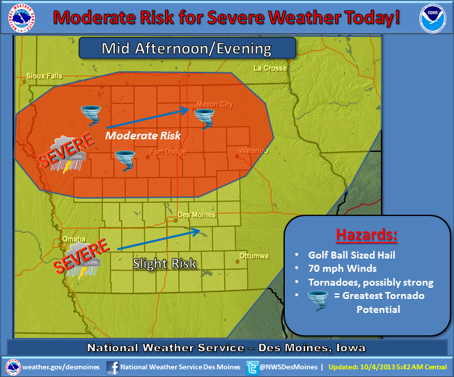
(Graphic) – NWS Severe Weather potential.
That activity will race northeast and into the area from late afternoon through mid-evening. Very large hail, damaging winds and a few tornadoes are likely, especially over the moderate risk region. A few severe storms with a heightened risk for damaging winds are likely over central and northern Iowa along with an attendant large hail and isolated tornado threat. This could become a potentially dangerous situation.
Be prepared to take appropriate actions if severe weather approaches your location. The storms will begin to weaken after midnight. By Saturday, a strong cold front will be passing through the area, ushering in much colder temperatures. Thunderstorm chances will pass to the east with dry and windy conditions in place by the afternoon.
COUNTIES: MONONA-HARRISON-SHELBY-POTTAWATTAMIE-MILLS-MONTGOMERY-FREMONT-PAGE-
THERE IS A MODERATE RISK FOR SEVERE THUNDERSTORMS OVER PARTS OF WEST CENTRAL IOWA, TODAY. THERE IS A SLIGHT RISK FOR SEVERE THUNDERSTORMS ACROSS THE REST OF THE OUTLOOK AREA.
THUNDERSTORMS ARE EXPECTED TO INITIALLY DEVELOP IN NORTHEAST
NEBRASKA NEAR AND AFTER 2 PM. THESE THUNDERSTORMS WILL MOVE ACROSS NORTHEAST NEBRASKA AND INTO WEST CENTRAL IOWA THROUGH 7 PM. THE MAIN THREATS FROM THESE THUNDERSTORMS WILL BE VERY LARGE
HAIL…SOME GREATER THAN 2 INCHES IN DIAMETER…STRONG WIND GUSTS
AND TORNADOES.
OTHER THUNDERSTORMS ARE EXPECTED TO DEVELOP ALONG AND EAST OF A
LINE FROM NEAR FREMONT, NE, TO BEATRICE, NE. THESE THUNDERSTORMS WILL LIKELY DEVELOP AFTER 4 PM AND MOVE EAST THROUGH EAST CENTRAL AND SOUTHEAST NEBRASKA BY 7 PM…AND ACROSS SOUTHWEST IOWA THROUGH 10 PM. LARGE HAIL…DAMAGING WINDS AND ISOLATED TORNADOES WILL BE POSSIBLE WITH THIS ACTIVITY.
Here are some reported rainfall amounts from the storms which fell from late Thursday afternoon through early this (Friday) morning (7-a.m.):
The Valley (Hwy 71/I-80 area in Cass County), 3.00″; Atlantic (KJAN), 2.12” (24-hour total…2.2″ as of 8-a.m.); Massena, 1.71″; Oakland, 2.00″; Audubon, .55″; a location south of Avoca, 2.87″; Emerson, .92″; Shenandoah, .23″, Red Oak, .90″, 3 1/4 miles south of Elk Horn received 3.8″, northeast of Atlantic 3.24″ of rain; 4-miles east of Council Bluffs, 2.44″.
If you have a rainfall amount you would like to report, call us at 1-800-283-5526, or e-mail: kjannews@metc.net. Please be sure and tell us where you’re from, the time you measured the rain and any other significant weather observations (Hail, damage, etc.). Thank You!
The Freese-Notis weather forecast for the KJAN listening area, and weather information for Atlantic, including rainfall for the past 24-hours (through 5:30-a.m.)

Podcast: Play in new window | Download (972.2KB)
Subscribe: RSS
Today: Scattered showers and thunderstorms, mainly after 4pm. Some of the storms could be severe. Partly sunny, with a high near 84. Breezy, with a light and variable wind becoming south 15 to 20 mph in the morning. Winds could gust as high as 28 mph. Chance of precipitation is 50%. New rainfall amounts between a quarter and half of an inch possible.
Tonight: Showers and thunderstorms, mainly before midnight. Some of the storms could be severe. Low around 45. South wind 9 to 11 mph becoming west southwest in the evening. Chance of precipitation is 80%. New rainfall amounts between a quarter and half of an inch possible.
Saturday: Mostly sunny, with a high near 54. Windy, with a west southwest wind 9 to 14 mph increasing to 18 to 23 mph in the afternoon. Winds could gust as high as 31 mph.
Saturday Night: A 20 percent chance of showers. Mostly cloudy, with a low around 38. West wind 10 to 14 mph, with gusts as high as 18 mph.
Sunday: Partly sunny, with a high near 57. West northwest wind 9 to 14 mph, with gusts as high as 18 mph.
Sunday Night: Mostly clear, with a low around 39.
Monday: Sunny, with a high near 68.
4:39-a.m. CDT 10/4/13
THE NATIONAL WEATHER SERVICE HAS CANCELLED SEVERE THUNDERSTORM WATCH 537 which had been in effect until 5-a.m. today. There are currently no other watches or warnings in effect for the KJAN listening area.


