
Shelby County Emergency Management Coordinator Bob Seivert says the Fire Danger index in the County will remain in the “Moderate” category through at least this Thursday, Oct. 10th. 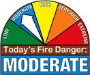 With winds expected to increase this week to around 30 miles per hour, Seivert says open burning should be avoided, especially on Tuesday.
The (podcast) Freese-Notis/Weather.Net forecast for the KJAN listening area, and weather information for Atlantic….

Podcast: Play in new window | Download (975.0KB)
Subscribe: RSS
(Updated 4:19-a.m.)
TODAY...SUNNY. MUCH WARMER. HIGH IN THE LOWER 70S. WEST WIND 5 TO 15 MPH.
TONIGHT…CLEAR. LOW IN THE MID 40S. SOUTH WIND 5 TO 10 MPH.
TUESDAY…MOSTLY SUNNY. BREEZY. HIGH IN THE MID 70S. SOUTH WIND 10 TO 15 MPH INCREASING TO 15 TO 25 MPH IN THE AFTERNOON.
TUESDAY NIGHT AND WEDNESDAY…MOSTLY CLEAR. LOW IN THE LOWER 50S. HIGH IN THE UPPER 70S. SOUTH WIND 10 TO 15 MPH WITH GUSTS TO AROUND 25 MPH.
WEDNESDAY NIGHT AND THURSDAY…MOSTLY CLEAR. LOW IN THE LOWER 50S. HIGH IN THE MID 70S.
THURSDAY NIGHT…PARTLY CLOUDY. LOW IN THE UPPER 50S.
FRIDAY…MOSTLY CLOUDY WITH A 40 PERCENT CHANCE OF THUNDERSTORMS. BREEZY. HIGH IN THE MID 70S.
FRIDAY NIGHT…PARTLY CLOUDY WITH A CHANCE OF SHOWERS AND ISOLATED THUNDERSTORMS. LOW IN THE LOWER 50S. CHANCE OF PRECIPITATION 30 PERCENT.
(Updated 5-a.m.)
Today: Rain. High near 48. W-NW wind at 10-25 mph. Chance of precipitation is 80%. New precipitation amounts between a tenth and quarter of an inch possible.
Tonight: Rain likely, mainly before midnight. Cloudy, then gradually becoming partly cloudy, with a low around 41. Northwest wind 10-20 mph. Chance of precipitation is 60%. New precipitation amounts of less than a tenth of an inch possible.
Monday: Mostly sunny, with a high near 69. West wind 5-10 mph.
Monday Night: Mostly clear, with a low around 46. South wind around 5 mph.
Tuesday: Sunny & breezy, with a high near 75. South wind 10-20 mph.
Tuesday Night: Mostly clear, with a low around 52.
Wednesday: Sunny & breezy, with a high near 77.
OMAHA, Neb. (AP) – A National Weather Service meteorologist says Friday evening’s tornado-spawning storms in northeastern Nebraska and northwestern Iowa were unusual for this time of year. Meteorologist Mike Fuhs in the service’s Sioux Falls, S.D., office says it’s unusual to get “not just this many tornadoes this late, but tornadoes this strong.” As many as nine tornadoes hit the area from 6 p.m. to 7:45 p.m. Friday, and some “were quite powerful,” according to Fuhs.
Fuhs says a couple of the tornadoes are estimated to have been one-quarter to one-half mile wide. He says it’s too early to estimate where the tornadoes will rank on the Enhanced Fujita Scale, which ranges from the weak EF0 to the top-of-the-scale EF5.
The weekend weather forecast from KJAN News Director Ric Hanson, and weather information for Atlantic….
Podcast: Play in new window | Download (840.3KB)
Subscribe: RSS
(information compiled by the National Weather Service)
8:00-p.m. Montgomery County Emergency Management reports trees were down in Red Oak due to high winds, and a lightening strike started a structure fire west of Red Oak.
6:40-p.m. Amateur radio operator reports 1-inch diameter (quarter-size) hail fell in the Rolling Hills area, east of Council Bluffs.
6:28-p.m. Law enforcement in Mills County report baseball-size hail fell along I-29 at the rest area and punched through a vehicle’s windshield. At that same time, quarter-size hail was reported to have fallen in Glenwood.
6:24-p.m. Golf ball-size hail was reported 3-miles west of Pacific Junction in Mills County.
344 AM CDT SAT OCT 5 2013 National Weather Service/Des Moines
EARLY THIS MORNING…PARTLY CLOUDY WITH A 20 PERCENT CHANCE OF LIGHT SHOWERS. COLDER. WEST WIND 10 TO 15 MPH.
TODAY…PARTLY SUNNY. BREEZY. MUCH COOLER. HIGH IN THE MID 50S. SOUTHWEST WIND 15 TO 20 MPH WITH GUSTS TO AROUND 30 MPH.
TONIGHT…MOSTLY CLOUDY. A 20 PERCENT CHANCE OF LIGHT RAIN EARLY IN THE MORNING. LOW AROUND 40. WEST WIND 5 TO 15 MPH.
SUNDAY…CLOUDY. A CHANCE OF LIGHT RAIN IN THE MORNING…THEN LIGHT RAIN LIKELY IN THE AFTERNOON. HIGH AROUND 50. NORTHWEST WIND 5 TO 15 MPH. CHANCE OF RAIN 70 PERCENT.
SUNDAY NIGHT…MOSTLY CLOUDY. A 20 PERCENT CHANCE OF LIGHT RAIN THROUGH MIDNIGHT. LOW IN THE LOWER 40S. NORTHWEST WIND 5 TO 10 MPH.
MONDAY…PARTLY SUNNY. WARMER. HIGH IN THE MID 60S. NORTHWEST WIND 5 TO 10 MPH.
MONDAY NIGHT AND TUESDAY…MOSTLY CLEAR. LOW IN THE MID 40S. HIGH IN THE LOWER 70S.
940 PM CDT FRI OCT 4 2013
THE NWS STORM PREDICTION CENTER HAS CANCELLED TORNADO WATCH NUMBER 539 ISSUED AT 240 PM CDT FOR PORTIONS OF IOWA and NEBRASKA. There are currently no Watches or Warnings in effect for the KJAN listening area.
TORNADO WATCH 541 REMAINS IN EFFECT UNTIL 1200 AM CDT FOR THE
FOLLOWING IOWA COUNTIES…
ADAIR ADAMS AUDUBON
BOONE CALHOUN CARROLL
CASS CERRO GORDO CLARKE
CRAWFORD DALLAS DECATUR
EMMET FRANKLIN GREENE
GUTHRIE HAMILTON HANCOCK
HARDIN HUMBOLDT KOSSUTH
MADISON PALO ALTO POCAHONTAS
POLK RINGGOLD SAC
STORY TAYLOR UNION
WARREN WEBSTER WINNEBAGO
WORTH WRIGHT


