
(Atlantic, Iowa – KJAN) – Weather data for the month of February, 2024 in Atlantic, shows we were much warmer and drier than average, last month. The Average High was 53, and the average Low was 21. Typically, we would have had a High of 35 and a Low of 15. Precipitation (melted snowfall) amounted to just one-tenth (.10″) of an inch, which was considerably less than the .96″ we would normally expect. Snowfall for the month was just one-inch.The data was compiled at KJAN, the official National Weather Serving reporting site for Atlantic.
Looking ahead, we find the Average High for the month of March, in Atlantic, is typically 48 degrees, while the Low should average out to be around 26. Precipitation (rain & or melted snow) is typically just under an inch, at 2.38 inches.
Today: Sunny, & windy. High near 59. S/SW @ 15-30 mph.
Tonight: Clear, with a low around 35. South wind 10-25 mph.
Saturday: Sunny & windy. High near 69. S @ 10-25 mph.
Sat. Night: Mostly clear & windy. Low around 53. S @ 15-40 mph.
Sunday: Sunny & windy. High near 75. S-W @ 20-40 mph.
Sun. Night: P/Cldy & windy w/a 20% chance of rain. Low around 40.
Monday: A 20% chance of rain before noon, otherwise Mostly sunny & windy. High near 64.
Tuesday: Mostly sunny, with a high near 54.
Thursday’s High in Atlantic was 58. The Low was 28. Last year on this date, the High in Atlantic was 51 and the Low was 24. The Record High for March 1st was 77 in 1992. The Record Low was -32 in 1962. Sunrise: 6:55. Sunset: 6:10-p.m.
(Atlantic, Iowa) – The City of Atlantic will begin seasonal weekly testing of outdoor warning sirens this Friday, at noon. Cass County Emergency Management Coordinator Mike Kennon says sirens serve to alert residents to take shelter indoors and seek more information. While the outdoor warning system can be an effective method of notifying those that are outdoors, to seek shelter indoors, it is only one part of a comprehensive emergency warning system. To receive emergency information during severe weather or other hazardous event you should get a NOAA weather radio, sign up for local emergency notifications, and tune in to local media reports, from radio, television or social media.
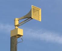 To report a faulty siren please call 254-1500 or email mkennon@casscoia.us. In your message please include location of the siren and a description of the issues you believe are occurring.
To register for the Cass County Emergency Notification System, go to links located on the Cass County homepage (http://www.casscountyiowa.us/) or the Cass County EMA Facebook page (https://www.facebook.com/CassCoEMA). If you need assistance, please contact Mike Kennon, Cass County Emergency Management Agency Coordinator at 712-254-1500.
Today: Sunny & windy. **RED FLAG WARNING from 10-a.m. until 6-p.m.** High near 58. SW winds 15-35 mph.
Tonight: Increasing clouds & breezy. Low around 32. S @ 15-30 mph.
Tomorrow: Partly-to-mostly sunny, & breezy. High near 59. S/SW @ 15-25 mph.
Friday Night: Clear, with a low around 34.
Saturday: Sunny & breezy, with a high near 69.
Saturday Night: Mostly clear & windy, with a low around 51.
Sunday: Sunny & windy, with a high near 76.
Wednesday’s High in Atlantic was 32. The Low was 6. Last (LEAP YEAR) on this date (2020) the High in Atlantic was 58 and the Low was 24. The Record High for Feb. 29th was 62 in 1992. The Record Low was -4 in 1960. Sunrise: 6:55. Sunset: 6:10.
Iowa’s rollercoaster weather is taking our wardrobe from shorts and t-shirts to winter coats, and back to shorts and t-shirts. While several Iowa cities saw record high temperatures in the 70s on Monday, today’s (Wednesday) highs will only be in the 30s after single-digit temps overnight along with scattered flurries. National Weather Service meteorologist Brad Small says today’s forecast will be fairly typical for late February, but a change is coming.
“We’ll be right back to where we started from to end the work week, with highs back into the 50s Thursday, 50s and 60s Friday,” Small says, “and if you look even further, into the weekend, highs back into the 70s again by the weekend.” The first day of Spring is March 19th.
Today: Sunny & breezy. High near 33. NW winds @ 10-25 mph. Wind chill values as low as -5.
Tonight: Clear, with a low around 21. S winds @ 10-25 mph.
Tomorrow: Sunny & windy. High near 57. S/SW winds 15-35 mph.
Friday: Sunny & windy, with a high near 62.
Saturday: Sunny & breezy, with a high near 70.
Tuesday’s High in Atlantic was 54. The Low was 6. Last year on this date the High in Atlantic was 42 and the Low was 23. The Record High for Feb. 28th was 71 in 1972. The Record Low was -23 in 1962. Sunrise: 6:58. Sunset: 6:08.
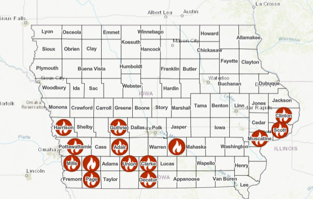
(Atlantic, Iowa) – Cass County Emergency Management Coordinator Mike Kennon reports an open burning ban is now in place for Cass County (Effective 2-p.m. Tuesday, February 27, 2024). The ban prohibits open and controlled burning in Cass County, Iowa; including all incorporated city limits within the county. (See the proclamation here )
The current drought conditions present an increased risk for the potential of rapid fire spread. Controlled fires can quickly become uncontrollable. It has been determined that open burning constitutes a danger to life or property.
During these dry conditions, citizens are reminded to not throw out cigarettes from moving vehicles and to discontinue burning yard waste, piled tree debris, grass/agricultural ground and set-asides or other items during the ban. Small recreational patio or camp fires are permitted only if they are conducted in a fire place of brick, metal or heavy one-inch wire mesh. Any camp fire not in an outdoor fire place is prohibited.![]()
Violation of a burn ban can subject a person to citation or arrest for reckless use of fire or disobeying a burn ban. The ban will remain in place until environmental conditions improve.
Any questions regarding this burn ban should be directed to your local Fire Chief.
Today: Mostly sunny, with a temperature rising to near 54 by 10am, then falling to around 36 during the remainder of the day. Windy, with a southwest wind 5 to 10 mph becoming north northwest 16 to 26 mph in the morning. Winds could gust as high as 32 mph. …WIND ADVISORY IN EFFECT FROM NOON TODAY TO 3 AM WEDNESDAY for sustained NW winds of 20-to 45 mph.
Tonight: A 30 percent chance of snow, mainly before 11pm. Cloudy during the early evening, then gradual clearing, with a low around 11. Wind chill values as low as -5. Windy, with a north northwest wind 18 to 28 mph, with gusts as high as 36 mph. New snow accumulation of less than a half inch possible.
Wednesday: Sunny, with a high near 34. Wind chill values as low as -5. Breezy, with a northwest wind 8 to 17 mph becoming west southwest in the afternoon. Winds could gust as high as 25 mph.
Thursday: Sunny, with a high near 56. Windy.
Friday: Sunny, with a high near 62. Windy.
Monday’s High of 78 in Atlantic smashed the old record of 72 set in 1896 (128 years ago). The Low was 33. Last year on this date the High in Atlantic was 45 and the Low was 24. The Record High for Feb. 27th was 71 in 2016. The Record Low was -16 in 1960. Sunrise: 6:58. Sunset: 6:08.
Here is a map of counties in Iowa that have a Burn Ban currently in-place until further notice. Updates are posted on the IDPS website.
Council Bluffs, Iowa – An open burning ban will be in effect immediately for all areas and jurisdictions in Pottawattamie County. The ban prohibits all open and controlled burning in Potawatamie County, including all incorporated city limits within the County.
The current dry conditions throughout the region have caused an increase in wild land fire incidents over the weekend. As dry conditions persist, dead and dying vegetation is the perfect fuel to spread fires rapidly. A Red Flag Warning was issued today due to conditions being prime for extreme fire behavior. This type of fire behavior is difficult to control and is extremely dangerous to responders and the public.
During these dry conditions, citizens are reminded to not throw out cigarettes from moving vehicles, and discontinue burning yard waste, piled tree debris or other items during the ban.
Violations of a burn ban can subject a person to criminal penalties as well as civil liabilities for any damages, losses, or injuries resulting from the fire.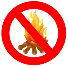
Visit the Emergency Management website at https://pcema-ia.org for more information on burn bans and the law. All residents are also encouraged to sign up for AlertIowa at the website to receive alerts for fire danger, evacuation notices, severe weather threats, and community emergency notifications.


