
The Iowa Department of Natural Resources reports precipitation for Iowa is below normal so far in 2014, receiving an average of 2.2 inches instead of the normal 2.6 inches by this time. The wettest area of the state is extreme southeast Iowa with 5 inches of moisture, and the driest areas are portions of the I-29 corridor which have received only about an inch.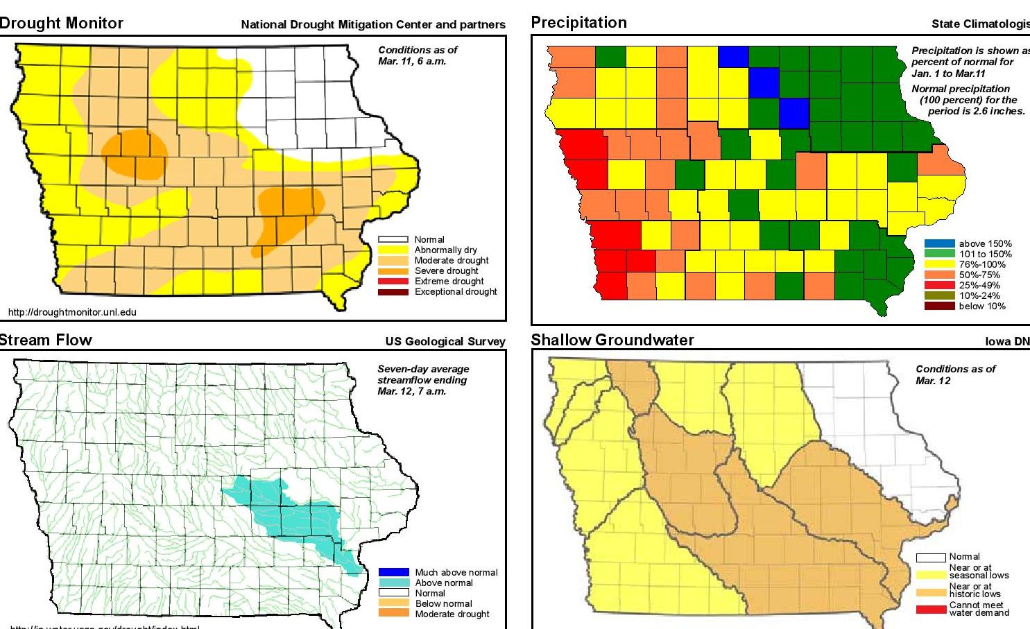
Stream flows are normal across the state for this time of year, except in the Iowa River watersheds, which are above normal.The area of extreme drought in Iowa has reduced in size from 20 percent of the state to 7 percent since the beginning of the year.
For a more thorough review of Iowa’s water resource trends January 1 through March 12, go to http://www.iowadnr.gov/watersummaryupdate. The report is prepared by the technical staff from the Iowa DNR, the Iowa Department of Agriculture and Land Stewardship, and the U.S. Geological Survey, in collaboration with The Iowa Homeland Security and Emergency Management Department.
The Freese-Notis (podcast) forecast for the KJAN listening area and weather information for Atlantic.

Podcast: Play in new window | Download (1.0MB)
Subscribe: RSS
Today: Sunny, with a high near 56. Windy, with a northwest wind 10 to 15 mph increasing to 18 to 23 mph in the afternoon. Winds could gust as high as 31 mph. Tonight: Mostly clear, with a low around 30. Blustery, with a west northwest wind 11 to 16 mph becoming light and variable. Winds could gust as high as 23 mph.
Saturday: Mostly sunny, with a high near 63. Southeast wind 6 to 14 mph, with gusts as high as 18 mph. Sat. Night: Rain likely between 7pm and 1am, then snow. Low around 24. Blustery, with a north northeast wind 14 to 20 mph, with gusts as high as 28 mph. Chance of precipitation is 80%. New snow accumulation of around an inch possible.
Sunday: Snow, mainly before 7am. High near 36. Breezy, with a north northeast wind 10 to 20 mph, with gusts as high as 28 mph. Chance of precipitation is 80%. New snow accumulation of less than a half inch possible. Sunday Night: Partly cloudy, with a low around 22.
Monday: Partly sunny, with a high near 52.
The Fire Weather Danger Index for much of far west and southwest Iowa and eastern Nebraska will be in the VERY HIGH category today!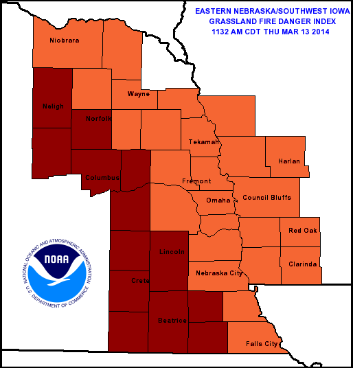 Emergency Management officials say you should be extremely cautious if you plan to burn outdoors today. There are currently no Burn Bans in effect, but officials say if the dry weather continues throughout the next few weeks that could change.
In anticipation of the rapid drying conditions forecast for this weekend, Shelby County Emergency Management officials say they will begin bi-weekly local fire danger assessments, next week.
Spring cleanup time is traditionally when a lot of people burn their brush piles.Officials say being aware of the potential for that small fire to spread due to wind and other meteorological conditions, conducive to rapid fire spread, is what the Fire Danger Assessment Program is all about. Monitoring the burning conditions will allow authorities to advise residents as to whether a controlled, open burn should be put off to a more favorable day, and save area volunteer firefighters from leaving their jobs for a burn which becomes uncontrollable.
Shelby County Emergency Management asks you to please call your controlled burns in to the Emergency Management Agency at 712-755-2124. Officials will take your information and put you in touch with the Fire Chief in your community.
The experts say major flooding on the Missouri River is NOT likely this year, but the runoff forecast in the basin above Sioux City has risen to 121-percent of normal, according to the U-S Army Corps of Engineers. Jody Farhat, chief of the Corps’ Missouri River Basin Water Management Division in Omaha, says while mountain snowpack is above average, they don’t expect a repeat of the widespread flooding of 2011.
“Runoff in the Missouri basin comes from three sources: plains snowpack, mountain snowpack and rainfall,” Farhat says. “It’s important to remember that the 2011 flood was the result of high runoff from all three of these sources. Currently, only one of those three conditions exists today, the above-normal mountain snowpack, so a repeat of the 2011 flood is highly unlikely.” Farhat says there is better communication now compared to three years ago.
“We do a lot more coordination now with the other federal agencies, the state climatologists and local folks on developing our runoff forecast and that’s a pretty significant change,” Farhat says. “We’re working with all of the folks that are gathering data and making sure that we’re all singing of the same sheet of music.” Dennis Todey, the South Dakota state climatologist who works with the Corps on forecasting, says the heavy rain storms that kicked off the massive 2011 flooding were very unusual.
“We can’t give any kind of a long-range outlook to say that something like that kind of storm in Montana in 2011 could or couldn’t happen again, but from a climatological perspective, that was a freakishly large storm where you had 50% of your annual rainfall in one event,” Todey says. “People need to understand that about how bizarre that precipitation event really was.” Farhat says the only areas that may see some minor flooding this year are downstream in Kansas and Missouri.
Earlier this week, the National Weather Service released its annual report on spring flooding risks in eastern Iowa. It said the flood risk for the Mississippi River from Dubuque to Burlington is above normal, the risk for the Cedar River at Cedar Rapids is normal, and the flood risk for the Iowa River at Iowa City is below-normal.
(Radio Iowa)
(Updated 3:56-a.m. – NWS/Des Moines)
Today: Sunny, with a high near 65. Breezy, with a west southwest wind 6 to 11 mph increasing to 13 to 18 mph in the afternoon. Winds could gust as high as 26 mph.
Tonight: Mostly clear, with a low around 36. Southwest wind around 11 mph.
Friday: Sunny, with a high near 55. Breezy, with a northwest wind 10 to 18 mph, with gusts as high as 25 mph.
Friday Night: Mostly clear, with a low around 31. West northwest wind 5 to 9 mph becoming light and variable after midnight.
Saturday: Mostly sunny, with a high near 54. East southeast wind 6 to 14 mph, with gusts as high as 18 mph.
Saturday Night: A chance of rain before 1am, then a chance of snow. Mostly cloudy, with a low around 26. Blustery. Chance of precipitation is 40%.
Sunday: Partly sunny, with a high near 38.
The (Podcast) Freese-Notis weather forecast for the KJAN listening area and weather information for Atlantic…
Podcast: Play in new window | Download (1.0MB)
Subscribe: RSS
Today: Partly sunny, with a high near 43. Breezy, with a north northwest wind around 17 mph, with gusts as high as 25 mph.
Tonight: Partly cloudy, with a low around 26. North northwest wind 5 to 8 mph becoming calm.
Thursday: Sunny, with a high near 63. West southwest wind 7 to 11 mph.
Thursday Night: Mostly clear, with a low around 35. Southwest wind 8 to 11 mph.
Friday: Sunny, with a high near 55. Northwest wind 8 to 14 mph, with gusts as high as 18 mph.
Friday Night: Partly cloudy, with a low around 31.
Saturday: Partly sunny, with a high near 51.
Saturday Night: A chance of rain and snow. Mostly cloudy, with a low around 27. Chance of precipitation is 30%.
Sunday: Partly sunny, with a high near 41.
COUNTIES: CRAWFORD-CARROLL-AUDUBON-GUTHRIE-DALLAS-CASS- ADAIR-MADISON-ADAMS-UNION-TAYLOR-RINGGOLD-SHELBY-POTTAWATTAMIE-MILLS-MONTGOMERY-FREMONT-PAGE…WIND ADVISORY REMAINS IN EFFECT UNTIL 10 PM.
* TIMING…THIS AFTERNOON AND EVENING. WINDS WILL SUBSIDE LATE TONIGHT BUT WILL REMAIN BREEZY INTO WEDNESDAY MORNING.
* WINDS…NORTHEAST WINDS OF 20 TO 35 MPH WITH GUSTS TO 40 MPH WILL CONTINUE THIS AFTERNOON BEFORE SHIFT NORTH TO NORTHWEST BY AROUND SUNRISE.
* IMPACTS…ANY OUTDOOR OBJECTS NOT FASTENED DOWN WILL LIKELY BE
BLOWN AROUND DUE TO THE STRONG WINDS. IN ADDITION…THERE IS THE
POTENTIAL FOR RAIN AND POSSIBLY SNOW LATE THIS AFTERNOON INTO
THE EVENING HOURS…AND COMBINED WITH THE GUSTY WINDS MAY CAUSE
DIFFICULT TRAVEL…ESPECIALLY ON WEST TO EAST ORIENTED ROADS.
PRECAUTIONARY/PREPAREDNESS ACTIONS…
A WIND ADVISORY MEANS THAT WINDS OF 35 MPH ARE EXPECTED. WINDS THIS STRONG CAN MAKE DRIVING DIFFICULT…ESPECIALLY FOR HIGH PROFILE VEHICLES. USE EXTRA CAUTION.


