
Here’s the (Podcast) Freese-Notis Weather forecast for the KJAN listening area & weather information for Atlantic.

Podcast: Play in new window | Download (997.3KB)
Subscribe: RSS
Today: Mostly sunny, with a high near 54. Windy, with a south wind 14 to 23 mph, with gusts as high as 31 mph. Tonight: Partly cloudy, with a low around 35. Breezy, with a south wind 16 to 18 mph, with gusts as high as 26 mph.
Tuesday: Rain likely, mainly after 4pm. Mostly cloudy, with a high near 53. Breezy, with a south wind 13 to 20 mph becoming west in the afternoon. Winds could gust as high as 28 mph. Chance of precipitation is 60%. New precipitation amounts of less than a tenth of an inch possible. Tuesday Night: Rain likely, possibly mixing with snow after 10pm, then gradually ending. Mostly cloudy, with a low around 30. Windy, with a northwest wind 18 to 24 mph, with gusts as high as 32 mph. Chance of precipitation is 60%. New snow accumulation of less than a half inch possible.
Wednesday: A 20 percent chance of rain after 1pm. Mostly sunny, with a high near 48. Breezy. Wednesday Night: Partly cloudy, with a low around 30.
Thursday: Sunny, with a high near 57.
COUNTIES: MONONA-HARRISON-SHELBY-POTTAWATTAMIE-MILLS-MONTGOMERY-FREMONT- PAGE–
347 AM CDT MON MAR 17 2014
…A FIRE WEATHER WATCH REMAINS IN EFFECT FROM 1 PM CDT THIS
AFTERNOON THROUGH THIS EVENING FOR LOW RELATIVE HUMIDITY AND
GUSTY WINDS.
* WIND…SOUTH TO SOUTHWEST AT 15 TO 25 MPH…WITH GUSTS TO 30
TO35 MPH.
* HUMIDITY…20 TO 25 PERCENT.
* IMPACTS…ANY FIRES THAT DEVELOP WILL LIKELY SPREAD RAPIDLY.
OUTDOOR BURNING IS NOT RECOMMENDED.
PRECAUTIONARY/PREPAREDNESS ACTIONS…
A FIRE WEATHER WATCH MEANS THAT CRITICAL FIRE WEATHER CONDITIONS
ARE FORECAST TO OCCUR. LISTEN FOR LATER FORECASTS AND POSSIBLE
RED FLAG WARNINGS.
446 AM CDT SUN MAR 16 2014
EARLY THIS MORNING…MOSTLY CLOUDY WITH A 20 PERCENT CHANCE OF SNOW. BREEZY. NORTHEAST WIND 15 TO 20 MPH WITH GUSTS TO AROUND 30 MPH.
TODAY…PARTLY SUNNY IN THE MORNING THEN CLEARING. BREEZY…COLDER. HIGH IN THE MID 30S. NORTHEAST WIND 10 TO 20 MPH. GUSTS UP TO 30 MPH IN THE MORNING. TONIGHT…PARTLY CLOUDY. LOW AROUND 20. EAST WIND AROUND 5 MPH SHIFTING TO THE SOUTH 5 TO 15 MPH AFTER MIDNIGHT.
MONDAY…MOSTLY SUNNY. BREEZY. MUCH WARMER. HIGH IN THE MID 50S. SOUTH WIND 10 TO 20 MPH WITH GUSTS TO AROUND 30 MPH. MONDAY NIGHT…PARTLY CLOUDY THROUGH MIDNIGHT THEN BECOMING MOSTLY CLOUDY. BREEZY. NOT AS COOL. LOW IN THE UPPER 30S. SOUTH WIND 10 TO 20 MPH. GUSTS UP TO 30 MPH THROUGH MIDNIGHT.
TUESDAY…PARTLY SUNNY. A 20 PERCENT CHANCE OF RAIN IN THE AFTERNOON. BREEZY. HIGH IN THE LOWER 50S. SOUTHWEST WIND 10 TO 20 MPH WITH GUSTS TO AROUND 30 MPH. TUESDAY NIGHT…MOSTLY CLOUDY. A CHANCE OF LIGHT RAIN AND LIGHT SNOW THROUGH MIDNIGHT…THEN A SLIGHT CHANCE OF SNOW AFTER MIDNIGHT. BREEZY. LOW AROUND 30. CHANCE OF PRECIPITATION 30 PERCENT.
WEDNESDAY AND WEDNESDAY NIGHT…PARTLY CLOUDY. BREEZY. HIGH IN THE UPPER 40S. LOW AROUND 30.
COUNTIES: AUDUBON-GUTHRIE-DALLAS–CASS-ADAIR-MADISON 907 PM CDT SAT MAR 15 2014
…PERIOD OF LIGHT TO MODERATE SNOW TO AFFECT AREA THROUGH EARLY SUNDAY MORNING… A BAND OF MODERATE SNOW OVER CENTRAL IOWA…WITH VISIBILITY REDUCED TO ONE HALF A MILE AT TIMES IS MOVING SOUTH INTO CENTRAL IOWA.
A BRIEF MIXTURE OF RAIN AND SNOW…CHANGING TO ALL SNOW WILL MOVE ACROSS THE AREA THROUGH EARLY SUNDAY MORNING. UP TO AN INCH OF ACCUMULATION IS POSSIBLE ON AREA ROADS…AND POSSIBLY 1 TO 3 INCHES ON GRASSY AREAS WITH THE HEAVIER AMOUNTS EXPECTED LATE TONIGHT SOUTH OF INTERSTATE 80.
ROADS MAY BECOME PARTIALLY TO MOSTLY SNOW COVERED AND SLIPPERY OVERNIGHT. MOTORISTS ARE URGED TO EXERCISE CAUTION AS THE BAND OF SNOW MOVES ACROSS THE REGION THROUGH LATE THIS EVENING AND OVERNIGHT. ALLOW EXTRA TIME TO REACH YOUR DESTINATION SAFELY.
(Updated 5:16-a.m./NWS Des Moines)
Today: Mostly sunny, with a high near 57. East northeast wind 7 to 13 mph.
Tonight: Rain, snow, and sleet, becoming all snow after 2am. Low around 22. Windy, with a north northeast wind 22 to 24 mph, with gusts as high as 32 mph. Chance of precipitation is 80%. New snow and sleet accumulation of around an inch possible.
Sunday: A 10 percent chance of snow before 7am. Cloudy, then gradually becoming mostly sunny, with a high near 36. Wind chill values as low as 10. Breezy, with a north northeast wind 11 to 20 mph, with gusts as high as 28 mph.
Sun. Night: Partly cloudy, with a low around 21. East northeast wind 5 to 10 mph becoming south southeast after midnight.
Monday: Partly sunny, with a high near 55. Breezy, with a south wind 11 to 18 mph, with gusts as high as 26 mph.
Tuesday: A 20 percent chance of rain. Partly sunny, with a high near 54. Breezy.
The Iowa Department of Natural Resources reports precipitation for Iowa is below normal so far in 2014, receiving an average of 2.2 inches instead of the normal 2.6 inches by this time. The wettest area of the state is extreme southeast Iowa with 5 inches of moisture, and the driest areas are portions of the I-29 corridor which have received only about an inch.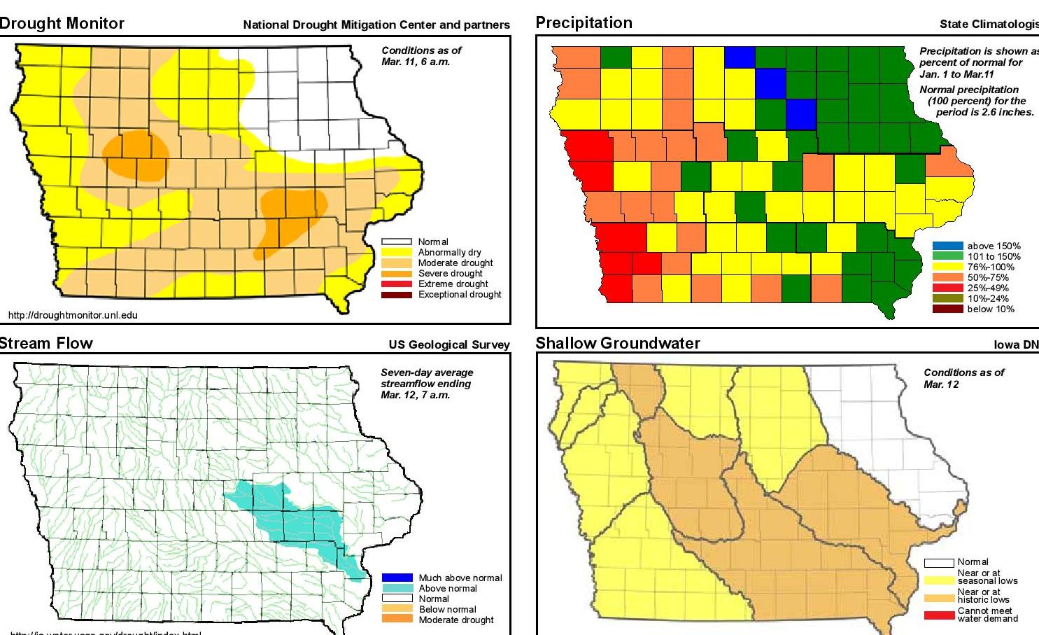
Stream flows are normal across the state for this time of year, except in the Iowa River watersheds, which are above normal.The area of extreme drought in Iowa has reduced in size from 20 percent of the state to 7 percent since the beginning of the year.
For a more thorough review of Iowa’s water resource trends January 1 through March 12, go to http://www.iowadnr.gov/watersummaryupdate. The report is prepared by the technical staff from the Iowa DNR, the Iowa Department of Agriculture and Land Stewardship, and the U.S. Geological Survey, in collaboration with The Iowa Homeland Security and Emergency Management Department.
The Freese-Notis (podcast) forecast for the KJAN listening area and weather information for Atlantic.
Podcast: Play in new window | Download (1.0MB)
Subscribe: RSS
Today: Sunny, with a high near 56. Windy, with a northwest wind 10 to 15 mph increasing to 18 to 23 mph in the afternoon. Winds could gust as high as 31 mph. Tonight: Mostly clear, with a low around 30. Blustery, with a west northwest wind 11 to 16 mph becoming light and variable. Winds could gust as high as 23 mph.
Saturday: Mostly sunny, with a high near 63. Southeast wind 6 to 14 mph, with gusts as high as 18 mph. Sat. Night: Rain likely between 7pm and 1am, then snow. Low around 24. Blustery, with a north northeast wind 14 to 20 mph, with gusts as high as 28 mph. Chance of precipitation is 80%. New snow accumulation of around an inch possible.
Sunday: Snow, mainly before 7am. High near 36. Breezy, with a north northeast wind 10 to 20 mph, with gusts as high as 28 mph. Chance of precipitation is 80%. New snow accumulation of less than a half inch possible. Sunday Night: Partly cloudy, with a low around 22.
Monday: Partly sunny, with a high near 52.
The Fire Weather Danger Index for much of far west and southwest Iowa and eastern Nebraska will be in the VERY HIGH category today!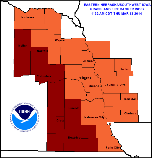 Emergency Management officials say you should be extremely cautious if you plan to burn outdoors today. There are currently no Burn Bans in effect, but officials say if the dry weather continues throughout the next few weeks that could change.


