
AREA COUNTIES: POTTAWATTAMIE-MILLS-MONTGOMERY-FREMONT-PAGE
A RED FLAG WARNING IS IN EFFECT FROM 11 AM TO 4 PM TODAY FOR WIND AND LOW RELATIVE HUMIDITY FOR PARTS OF EASTERN NEBRASKA AND WESTERN IOWA. THE FIRE WEATHER WATCH IS NO LONGER IN EFFECT.
THE NATIONAL WEATHER SERVICE IN OMAHA/VALLEY HAS ISSUED A RED FLAG WARNING FOR WIND AND LOW RELATIVE HUMIDITY.
* WINDS…SOUTHWEST 25 TO 30 MPH WITH GUSTS UP TO 40 MPH.
* RELATIVE HUMIDITY…AS LOW AS 15 T0 25 PERCENT.
* IMPACTS…VEGETATION IS VERY DRY ACROSS THE AREA. WITH LOW RELATIVE HUMIDITY…GUSTY WINDS…AND DRY FUELS…FIRES CAN IGNITE AND SPREAD QUICKLY.
PRECAUTIONARY/PREPAREDNESS ACTIONS... A RED FLAG WARNING MEANS THAT CRITICAL FIRE WEATHER CONDITIONS ARE EITHER OCCURRING NOW…OR WILL SHORTLY. A COMBINATION OF STRONG WINDS…LOW RELATIVE HUMIDITY…AND WARM TEMPERATURES CAN CONTRIBUTE TO EXTREME FIRE BEHAVIOR.
(Update 3:57-a.m.)
Today: Wind Advisory in effect from Noon until 7-pm. A 20 percent chance of showers and thunderstorms before 9am. Mostly sunny, with a high near 71. Windy, with a south wind 22 to 29 mph, with gusts as high as 44 mph.
Tonight: Partly cloudy, with a low around 24. Wind chill values as low as 10. Windy, with a west wind 23 to 31 mph, with gusts as high as 44 mph.
Tuesday: Mostly sunny, with a high near 45. Breezy, with a northwest wind 13 to 18 mph decreasing to 6 to 11 mph in the afternoon. Winds could gust as high as 26 mph.
Tue.Night: A 20 percent chance of showers after 1am. Cloudy, with a low around 33. Northeast wind 6 to 9 mph.
Wednesday: Showers likely, mainly after 1pm. Cloudy, with a high near 45. Breezy, with an east northeast wind 10 to 16 mph, with gusts as high as 23 mph. Chance of precipitation is 60%. New precipitation amounts of less than a tenth of an inch possible.
Wed. Night: A 40 percent chance of rain. Cloudy, with a low around 35. Breezy. New precipitation amounts of less than a tenth of an inch possible.
Thursday: A 50 percent chance of rain. Cloudy, with a high near 47. Breezy.
COUNTIES: AUDUBON-GUTHRIE-DALLAS-CASS-ADAIR-MADISON-ADAMS-UNION-TAYLOR-RINGGOLD 358 AM CDT MON MAR 31 2014
WIND ADVISORY IN EFFECT FROM NOON TODAY TO 7 PM CDT THIS EVENING.
COUNTIES: POTTAWATTAMIE-MILLS-MONTGOMERY-FREMONT-PAGE-
353 AM CDT MON MAR 31 2014
WIND ADVISORY REMAINS IN EFFECT FROM 10 AM THIS MORNING TO 10 PM CDT THIS EVENING.
* TIMING…STRONG WINDS WILL DEVELOP BY LATE MORNING AND INCREASE
INTO THE AFTERNOON HOURS. A SECONDARY COLD FRONT WILL KEEP WINDS
STRONG OVERNIGHT.
* WINDS…SOUTHWEST WINDS OF 25 TO 35 MPH WITH GUSTS TO 50 MPH
ARE EXPECTED, WITH THE STRONGER WINDS IN THE FAR WEST/SW COUNTIES.
* IMPACTS…WINDS THIS STRONG CAN MAKE DRIVING DIFFICULT…
ESPECIALLY FOR HIGH PROFILE VEHICLES. LOOSE OR UNSECURED OBJECTS
WILL BLOW AROUND EASILY AND MAY CAUSE DAMAGE OR INJURY. IN
ADDITION…DUE TO THE WARM TEMPERATURES…OUTDOOR BURNING OF
ANY KIND IS HIGHLY DISCOURAGED THIS AFTERNOON BECAUSE THE STRONG
WINDS MAY QUICKLY CAUSE ANY FIRE TO GET OUT OF CONTROL.
PRECAUTIONARY/PREPAREDNESS ACTIONS…
A WIND ADVISORY MEANS THAT WINDS OF 35 MPH ARE EXPECTED. WINDS
THIS STRONG CAN MAKE DRIVING DIFFICULT…ESPECIALLY FOR HIGH
PROFILE VEHICLES. USE EXTRA CAUTION.
POTTAWATTAMIE-MILLS-MONTGOMERY COUNTIES: WIND ADVISORY IN EFFECT MONDAY FROM 10-A.M. UNTIL 10-P.M.
MONONA-HARRISON-SHELBY COUNTIES: WIND ADVISORY IN EFFECT FROM NOON MONDAY TO 1 AM CDT TUESDAY.
* TIMING…WINDS WILL INCREASE BY NOON MONDAY AND WILL LINGER UNTIL AROUND MIDNIGHT TOMORROW NIGHT.
* WINDS…SOUTHWESTERLY WINDS INCREASING MONDAY MORNING TO AROUND 30 MPH WITH GUSTS UP TO 40 MPH…BECOMING WEST…THEN NORTHWEST BY MONDAY EVENING.
* IMPACTS…WINDS THIS STRONG WILL MAKE DRIVING OF HIGH PROFILE OR LIGHT VEHICLES DIFFICULT ON EAST TO WEST ROADS. BLOWING DUST AND OTHER DEBRIS COULD REDUCE VISIBILITIES…ESPECIALLY IN OPEN AREAS. LOOSE OBJECTS SUCH AS GARBAGE CANS WILL BE TOSSED AROUND.
PRECAUTIONARY/PREPAREDNESS ACTIONS… A WIND ADVISORY MEANS THAT SUSTAINED WIND SPEEDS BETWEEN 30 TO 39 MPH OR GUSTS BETWEEN 45 TO 57 MPH ARE EXPECTED. WINDS THIS STRONG CAN MAKE DRIVING DIFFICULT…ESPECIALLY FOR HIGH PROFILE VEHICLES. USE EXTRA CAUTION.
COUNTIES: POTTAWATTAMIE-MILLS-MONTGOMERY-FREMONT-PAGE
346 PM CDT SUN MAR 30 2014 …RED FLAG WARNING REMAINS IN EFFECT UNTIL 8 PM CDT THIS EVENING FOR WIND AND LOW RELATIVE HUMIDITY FOR SOUTHEAST NEBRASKA AND SOUTHWEST IOWA… …
FIRE WEATHER WATCH IN EFFECT FROM MONDAY AFTERNOON THROUGH MONDAY EVENING FOR WIND AND LOW RELATIVE HUMIDITY FOR SOUTHEAST NEBRASKA AND SOUTHWEST IOWA.
AREA COUNTIES: SAC-CRAWFORD-CARROLL-AUDUBON-GUTHRIE-DALLAS-CASS-ADAIR-MADISON-ADAMS-UNION-TAYLOR-RINGGOLD
603 AM CDT SUN MAR 30 2014
…ELEVATED FIRE DANGER THIS AFTERNOON…
STRONG SOUTH WINDS OF 25 TO 30 MPH…WITH GUSTS NEAR 40 MPH AT
TIMES…WILL DEVELOP ACROSS THE AREA LATE THIS MORNING AND
AFTERNOON. THE GUSTY WINDS WILL PERSIST THROUGH EARLY EVENING. IN
ADDITION…RATHER DRY AIR IS EXPECTED ACROSS THE AREA WITH
RELATIVE HUMIDITY FALLING TO AROUND 30 TO 35 PERCENT AT TIMES
TODAY FROM NOON THROUGH EARLY EVENING. THIS WILL LEAD TO AN
ENHANCED FIRE DANGER…WITH ANY FIRES THAT START EXPECTED TO
SPREAD RAPIDLY. BURNING IS HIGHLY DISCOURAGED TODAY.
SIMILAR CONDITIONS WILL RETURN TO SOUTHWEST AREAS MONDAY WITH
GUSTY WEST TO SOUTHWEST WINDS AND LOW RELATIVE HUMIDITY.
AREA COUNTIES: SAC-CRAWFORD-CARROLL-AUDUBON-GUTHRIE-DALLAS-CASS-ADAIR-MADISON-ADAMS-UNION-TAYLOR-RINGGOLD…
343 PM CDT SAT MAR 29 2014
GUSTY WINDS SOUTHWESTERLY WINDS OF 20 TO 35 MPH WITH HIGHER GUSTS
ARE POSSIBLE SUNDAY ACROSS MUCH OF THE AREA. HUMIDITY WILL FALL TO
30 TO 40 PERCENT. THE COMBINATION OF THE WINDS AND LOW HUMIDITY
WILL PRODUCE AN ENHANCED FIRE DANGER OVER THE STATE…ESPECIALLY
THE SOUTHWEST HALF.
THERE IS A CHANCE OF THUNDERSTORMS ON MONDAY. A FEW STORMS COULD
BE SEVERE…WITH DAMAGING WINDS AND HAIL THE PRIMARY THREATS.
HOWEVER AN ISOLATED TORNADO CANNOT BE RULED OUT.
ANOTHER STORM SYSTEM WILL IMPACT THE AREA MID WEEK WITH A CHANCE
FOR AN ISOLATED THUNDERSTORM TUESDAY NIGHT INTO WEDNESDAY. IT IS
TOO EARLY TO DETERMINE ANY SEVERE THREATS WITH THIS SYSTEM.
.SPOTTER INFORMATION STATEMENT…
SPOTTER ACTIVATION MAY BE NEEDED MONDAY.
The National Weather Service forecast for the KJAN listening area and weather data for Atlantic.

Podcast: Play in new window | Download (913.8KB)
Subscribe: RSS
The Iowa Department of Natural Resources, Friday, released their latest precipitation information and drought report. Officials say the past two weeks have been unusually dry across most of Iowa. The statewide average precipitation was 0.19 inches, while normal for the period is 1.01 inches. Salem in Henry County in southeast Iowa was one exception, receiving over an inch during this period. Precipitation in Cass and surrounding Counties is 10-percent below normal for the period covering March 12th through the 26th.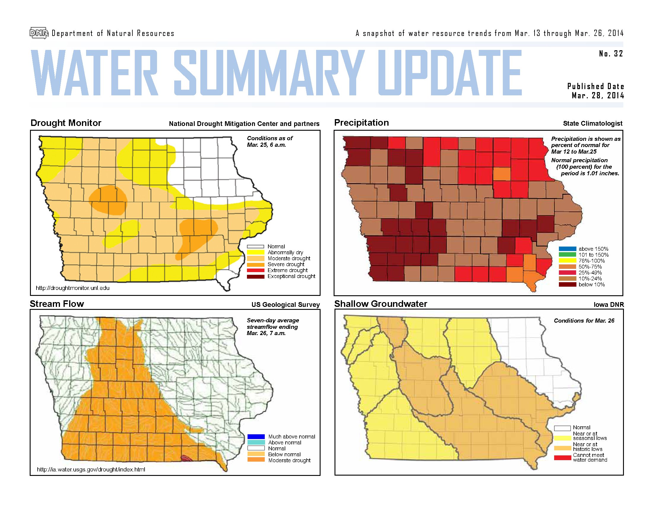
About seven percent of the state remains in severe drought, while about half of the state is rated in moderate drought, including most of western and southern Iowa, with the exception of Adair, Guthrie and Dallas Counties, which are “Abnormally Dry.” This is reflected in the drop of average stream flow in Iowa. Recent rains are reflected in the stream flow index upturn for the past few days.
South of Interstate 80, ice is almost completely gone from rivers. Iowa DNR fisheries biologists continue to monitor oxygen levels in many waters and have seen some slight improvements in some places. Considerable areas of ice remain in northern Iowa.
For a more thorough review of Iowa’s water resource trends March 12th through March 26th, go to http://www.iowadnr.gov/watersummaryupdate.
Iowa’s first tornado of 2014 touched down Thursday afternoon (March 27th) in rural Clarke County, south of Osceola. No injuries are reported but the strong winds did damage, tearing down tree limbs, knocking down power lines and causing some structural damage to a homestead. Jeff Johnson, the warning coordination meteorologist at the National Weather Service, says it may’ve been small, but it was a twister. “Based on the radar data and some eyewitness accounts and then some damage that was reported, we did have a brief tornado,” Johnson says. “The eyewitness report said it lasted roughly a minute.”
The funnel cloud touched down in south-central Iowa and became a tornado around 4:30 P-M, though its duration and scope was limited. “Basically, we had a Morton building that was damaged and damage to someone’s home and the winds were consistent in the range of EF-0 or EF-1 on the enhanced Fujita scale,” Johnson says. “That would put us around 90 miles an hour for wind speeds.”
This is the first confirmed report of a tornado in Iowa this year and the first in nearly six months. “The last time we had tornadoes in Iowa was last fall,” Johnson says. “We had a very active fall actually and on October 4th in northwest Iowa, we had several tornadoes.”
This is Severe Weather Awareness Week in Iowa, an event that’s highlighted by a statewide tornado drill that was held on Wednesday. It’s a time when Iowans are reminded about the sometimes-violent weather that comes with the arrival of spring. “It’s not a coincidence that we have it during this time of year,” Johnson says, “although we usually like to have the week out of the way before we actually get the weather, but Mother Nature seldom cooperates. The irony there is that the tornado came a day after the tornado drill.”
(Radio Iowa)


