
Today: Sunny, with a high near 43. Calm wind becoming north northwest 5 to 8 mph in the afternoon.
Tonight: A 20 percent chance of snow after 5am. Increasing clouds, with a low around 24. East wind around 7 mph.
Tomorrow: Rain, snow, and freezing rain likely before 11am, then rain and snow likely between 11am and noon, then rain after noon. High near 39. East wind 7 to 11 mph. Chance of precipitation is 100%. New ice accumulation of less than a 0.1 of an inch possible. New snow accumulation of less than a half inch possible.
Thursday Night: Rain before 3am, then a slight chance of rain and snow. Low around 30. East wind 5 to 7 mph becoming calm. Chance of precipitation is 80%. Little or no snow accumulation expected.
Friday: Mostly cloudy, with a high near 37.
Saturday: Partly sunny, with a high near 42.
Tuesday’s High in Atlantic was 44. Our Low this morning, 14. Last year on this date the High in Atlantic was 41 and the Low was 15. The Record High on this date was 64 in 1894. The Record Low was -15 in 2005.
(Radio Iowa) – Forecasters say another storm system is expected to reach the state later this week that could bring snow across Iowa’s northern half and rain to the south. Meteorologist Cory Martin, at the National Weather Service, says the divider line between snow and rain runs from Council Bluffs to Des Moines to Cedar Rapids to Dubuque, but just a few degrees shift in the temperature could make all the difference.
“Temperatures are going to be warm enough to support actually a fair share of rain probably for a good chunk of the area as the storm system moves in through the day on Thursday,” Martin says. “If we’re looking for any snow, it may be confined to far northern Iowa, whereas further south, right now, we’re looking at warm enough for some rain to fall.” Once the sun sets on Thursday night, Martin says those conditions could change — or not — as the system is still developing. 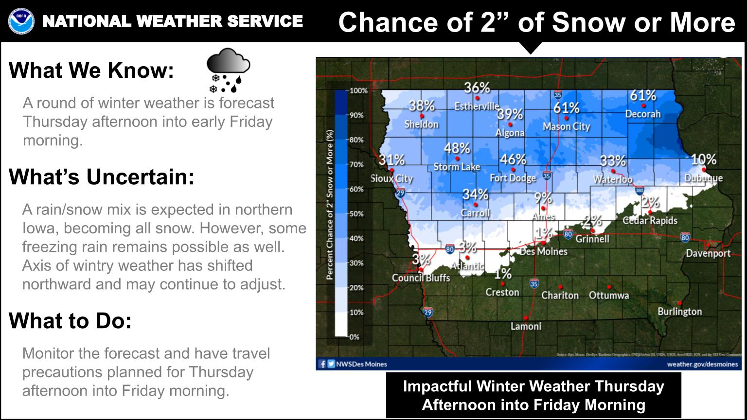
“Thursday night into Friday morning, temperatures may cool enough to allow that rain-snow line to sink further south and into central Iowa,” Martin says, “so, still quite a bit of uncertainty there and just how far south we’re going to see snow, just because we’re talking the difference of just a degree or two.” Wide sections of north-central and northeast Iowa may see two or more inches of snow, which could make driving hazardous from Mason City to Decorah.
“It’s certainly possible up there that we’re going to see slick and snow-covered roads that may impact your travel especially as we get into Thursday night,” Martin says. “Once the sun goes down, temperatures cool a little bit more, so that’s definitely something that we’ll be monitoring.” Keep up with the developing forecast at weather-dot-gov.
Today: Partly-to-Mostly Cloudy w/scattered flurries this morning. High 40. E/SE @ 5-10 mph. (Updated 6:45-a.m.)
Tonight: Partly cloudy. Low 20. Wind light & variable.
Tomorrow: P/Cldy. High 43. Winds variable @ 5-10 mph.
Thursday: Mo. Cldy w/a chance of light rain, especially in the afternoon. High near 38.
Friday: Cloudy with a chance of snow in the morning; Becoming P/Cldy. High 34.
Monday’s High in Atlantic was 46. The Low was 21. Last year on this date, the High in Atlantic was 26, and the Low was 8. The Record High was 69 degrees in 1939, and the Record Low was -12, in 2005.
Today: Partly cloudy. High 42. Winds SW-N @ 10-15.
Tonight: Mostly cloudy. Low 23. NE @ 5-10.
Tomorrow: P/Cldy to Mo. Cldy. High 38. E/SE @ 5-10.
Wednesday: P/Cldy to Cldy. High 38.
Thursday: Mostly cloudy w/a chance of light rain in the afternoon. High 36.
Sunday’s High in Atlantic was 46. The Low was 20. Last year on this date the High in Atlantic was 52 and the Low was 23. The Record High on this date was 66 in 2001. The Record Low was -14 in 2005.
Today: Mostly sunny, with a high near 44. South southwest wind 5 to 9 mph.
Tonight: Partly cloudy, with a low around 26. South wind 6 to 8 mph.
Monday: Partly sunny, with a high near 41. South southwest wind 7 to 15 mph becoming north in the afternoon. Winds could gust as high as 21 mph.
Monday Night: Mostly cloudy, with a low around 18. North northeast wind 6 to 10 mph, with gusts as high as 18 mph.
Tuesday: Mostly cloudy, with a high near 35. East southeast wind 3 to 7 mph.
Tuesday Night: Partly cloudy, with a low around 18.
Wednesday: Mostly sunny, with a high near 38.
Saturday’s High in Atlantic was 31. The Low was 8. Last year on this date the High in Atlantic was 47 and the Low was 28. The Record High on this date was 66 in 1998. The Record Low was -8 in 1905.
Today: Partly cloudy. High 31. NW-SW @ 10-15 mph.
Tonight: Fair to p/cldy. Low 18. SW @ 5-10.
Tomorrow: P/Cldy. High 43. SW @ 10-15.
Monday: Mostly cloudy. High 41.
Tuesday: Mo. Cldy. High 34.
Friday’s High in Atlantic was 60. The Low was 11. Last year on this date the High in Atlantic was 60 and the Low was 30. The Record High on this date was 64 in 2017. The Record Low was -13 in 1919.
(Radio Iowa) -Things are going to get pretty windy across the state today (Friday). Jeff Zogg of the National Weather Service says this impacts every county. “There’s a pretty strong cold front that’s going to be moving across the state later on today into this evening. And especially behind that, the winds are going to pick up. We have a wind advisory for the entire state for later this afternoon into this evening,” Zogg says Zogg says there could be some pretty powerful gusts.
“Northwest winds 25 to 35 with gusts of 50 to 55 miles per hour possible,” he says. You might want to be sure everything in your yard is secure. “With those winds, definitely has the possibility to blow around unsecured objects — including holiday decorations if they’re out– and tree limbs could be blown down and there could be some power outages as a result of that,” Zogg says. You can also say goodbye to the warm temperatures.
“This will be the warmest day that we’ll see for a little bit. Highs on Saturday across the state will range from the lower 20s to the middle 30s,” Zogg says. Those driving high-profile vehicles this afternoon and evening should use caution in the high winds.
Today: Partly cloudy & windy. High 55. Winds S/SW winds @ 20-35 mph becoming NW late.
Tonight: **WIND ADVISORY from 6-pm until 3-a.m. Saturday** P/Cldy Low 14. NW @ 15-30.
Tomorrow: P/Cldy. High 31. W @ 10-15.
Sunday: P/Cldy. High 43.
Monday: P/Cldy. High 41.
Thursday’s High in Atlantic was 49. The Low was 23. Last year on this date the High in Atlantic was 65 and the Low was 32. The Record High on this date was 65 in 2021. The Record Low was -10 in 1985.
(Radio Iowa) – State climatologist Justin Glisan says November numbers were unremarkable except for a little bump up in precipitation. “A little over two inches for the statewide average — and that’s almost three-tenths of an inch above average. So, the first month of the fall season in which we had above average precipitation for the state,” Glisan says. He says the temperature was right in line with the average.
“Overall if we look at temperatures right at 37 degrees that average temperature, so the daytime high overnight low add them together and divide by two, so right on the button in terms of climatology,” he says. Glisan says the short-term forecast for December is mixed.
“As we move into December and January — the two coldest and driest months of the year — when we look at the outlook for six to ten and eight to 14 days — we do see an elevated signal for colder temperatures and then near normal precipitation, so at least to the first half of the month,” according to Glisan. The longer-term forecast doesn’t signal a lot of snowfall.
“Elevated probabilities of colder and drier conditions for the state. So, that suggests less snowfall. Now we’re still stuck in that La Nina phase which dictates where the storm tracks that’s up over the United States,” Glisan says. “So we are seeing basically a classic line in your signature on the precipitation front and what you see a bullseye of above average precipitation in the Ohio Valley in the Pacific Northwest, but that dry signal is showing up for the state of Iowa.” He says the forecast now for later in the winter shows a shift from LaNina to a more neutral position.
“Right in between La Nina and El Nino as we get into the February, March April timeframe. So we’re seeing a shift in the probability of what are the normal conditions across the eastern half of Iowa, and an equal chance of above below, or near average in western Iowa,” Glisan says. Today marks the beginning of the meteorological winter in the northern hemisphere.
(Atlantic, Iowa – KJAN) – The month of November here in Atlantic was, on average, three degrees warmer than normal as far as the High is concerned, at 49-degrees. Conversely, it was nearly three degrees cooler for the Low, at 24-degrees. Precipitation for the month continued the trend of being much less than what we would typically expect. Liquid precipitation (melted snow/ice & actual rain) in November amounted to just .91″ (91-hundredths of an inch), which was nearly an inch (.94″) less than what we should have had.
Here’s what the the stats for Atlantic normally are, for December:


