
Today Scattered showers, mainly after 7am. Cloudy, with a high near 64. Breezy, with a south southwest wind 14 to 18 mph, with gusts as high as 26 mph. Chance of precipitation is 50%. New precipitation amounts between a tenth and quarter of an inch possible.
Tonight Showers likely, mainly before midnight. Cloudy, then gradually becoming partly cloudy, with a low around 37. South southwest wind 9 to 13 mph becoming northwest after midnight. Winds could gust as high as 20 mph. Chance of precipitation is 60%. New precipitation amounts of less than a tenth of an inch possible.
Tuesday Sunny, with a high near 57. Northwest wind 8 to 11 mph.
Tuesday Night Mostly clear, with a low around 36. Southwest wind 5 to 7 mph.
Wednesday Partly sunny, with a high near 61. South southwest wind 7 to 15 mph becoming west in the afternoon. Winds could gust as high as 21 mph.
Thursday Mostly sunny, with a high near 48. Windy.
345 AM CST SUN NOV 2 2014
EARLY THIS MORNING…MOSTLY CLOUDY. NOT AS COOL. SOUTH WIND 10 TO 15 MPH.
TODAY...MOSTLY SUNNY. BREEZY…WARMER. HIGH AROUND 60. SOUTH WIND 15 TO 25 MPH WITH GUSTS TO AROUND 35 MPH.
TONIGHT...PARTLY CLOUDY UNTIL EARLY MORNING THEN BECOMING MOSTLY CLOUDY. NOT AS COOL. LOW IN THE UPPER 40S. SOUTH WIND AROUND 15 MPH WITH GUSTS TO AROUND 30 MPH.
MONDAY…CLOUDY. A CHANCE OF SHOWERS IN THE MORNING…THEN SHOWERS LIKELY IN THE AFTERNOON. BREEZY. HIGH IN THE UPPER 50S. SOUTH WIND 15 TO 20 MPH WITH GUSTS TO AROUND 30 MPH. CHANCE OF SHOWERS 70 PERCENT.
MONDAY NIGHT…CLOUDY WITH SHOWERS LIKELY THROUGH MIDNIGHT…THEN PARTLY CLOUDY WITH A SLIGHT CHANCE OF SHOWERS AFTER MIDNIGHT. LOW IN THE UPPER 30S. WEST WIND 10 TO 15 MPH. CHANCE OF SHOWERS 60 PERCENT.
TUESDAY...SUNNY. HIGH IN THE UPPER 50S. WEST WIND 10 TO 15 MPH.
TUESDAY NIGHT…PARTLY CLOUDY. LOW IN THE UPPER 30S.
WEDNESDAY…PARTLY SUNNY WITH A 20 PERCENT CHANCE OF RAIN SHOWERS. HIGH IN THE UPPER 50S.
(Updated 4:30-p.m. Sat., 11/1/14)
Tonight – Partly cloudy, with a low around 33. South wind 11 to 15 mph, with gusts as high as 21 mph.
Sunday – Mostly sunny, with a high near 60. Windy, with a south wind 16 to 24 mph, with gusts as high as 33 mph.
Sunday Night – A 20 percent chance of showers after 1am. Partly cloudy, with a low around 45. South wind 11 to 15 mph, with gusts as high as 21 mph.
Monday – Showers likely, mainly after 1pm. Cloudy, with a high near 61. Breezy, with a south wind 11 to 17 mph, with gusts as high as 25 mph. Chance of precipitation is 70%. New precipitation amounts between a tenth and quarter of an inch possible.
Monday Night – Showers likely, mainly before 1am. Mostly cloudy, with a low around 39. Chance of precipitation is 70%. New precipitation amounts between a tenth and quarter of an inch possible.
Tuesday – Sunny, with a high near 54.
Tuesday Night – Mostly clear, with a low around 36.
Wednesday – Mostly sunny, with a high near 59.
330 AM CDT FRI OCT 31 2014
EARLY THIS MORNING…PARTLY CLOUDY. BREEZY…COLDER. NORTH WIND 15 TO 25 MPH.
TODAY…SUNNY…BREEZY. MUCH COLDER. HIGH IN THE LOWER 40S. NORTH WIND 10 TO 20 MPH.
TONIGHT…MOSTLY CLEAR. LOW IN THE MID 20S. NORTHEAST WIND NEAR 5 MPH SHIFTING TO THE SOUTHEAST AFTER MIDNIGHT.
SATURDAY…MOSTLY SUNNY. HIGH IN THE MID 40S. SOUTH WIND 5 TO 15 MPH WITH GUSTS TO AROUND 25 MPH.
SATURDAY NIGHT AND SUNDAY…PARTLY CLOUDY. BREEZY. LOW IN THE MID 30S. HIGH 46 TO 57. SOUTH WIND 5 TO 20 MPH WITH GUSTS TO AROUND 30 MPH.
SUNDAY NIGHT…MOSTLY CLOUDY. LOW IN THE MID 40S.
MONDAY…CLOUDY WITH A 40 PERCENT CHANCE OF SHOWERS. HIGH IN THE LOWER 60S.
The Shelby County Emergency Management Agency said Thursday that a slight increase in the fire danger can be expected for the next few days. Mostly sunny skies with above average winds over the next couple of days will facilitate drying of the grass and crops.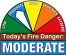
Officials say residents should use caution when responding to field fires. Some of the low lying ground is very soft and the weight of fire fighting vehicles may result in getting stuck in places difficult to get out of.
Fire Danger signs will be moved into the “Moderate” risk category, from now through Monday November 3rd.
345 AM CDT THU OCT 30 2014
EARLY THIS MORNING…MOSTLY CLOUDY. ISOLATED SPRINKLES. SOUTH WIND NEAR 5 MPH.
TODAY…MOSTLY SUNNY. ISOLATED SPRINKLES THROUGH MID MORNING. HIGH AROUND 60. SOUTHWEST WIND NEAR 5 MPH INCREASING TO NORTHWEST 10 TO 15 MPH WITH GUSTS TO AROUND 25 MPH IN THE AFTERNOON.
TONIGHT…MOSTLY CLOUDY UNTIL EARLY MORNING THEN CLEARING. BREEZY. LOW IN THE UPPER 20S. NORTH WIND 10 TO 20 MPH WITH GUSTS TO AROUND 30 MPH.
FRIDAY…SUNNY…COLDER. HIGH IN THE LOWER 40S. NORTH WIND 5 TO 15 MPH WITH GUSTS TO AROUND 25 MPH.
FRIDAY NIGHT…MOSTLY CLEAR. LOW IN THE MID 20S. NORTHEAST WIND NEAR 5 MPH SHIFTING TO THE EAST AFTER MIDNIGHT.
SATURDAY...MOSTLY SUNNY. HIGH IN THE MID 40S. SOUTHEAST WIND 5 TO 15 MPH WITH GUSTS TO AROUND 25 MPH.
SATURDAY NIGHT AND SUNDAY...PARTLY CLOUDY. BREEZY. LOW IN THE MID 30S. HIGH 46 TO 56.
The Freese-Notis forecast for the KJAN listening area and weather information for Atlantic.

Podcast: Play in new window | Download (978.4KB)
Subscribe: RSS
345 AM CDT WED OCT 29 2014
EARLY THIS MORNING…MOSTLY CLEAR. COLDER. WEST WIND NEAR 10 MPH.
TODAY…SUNNY. HIGH IN THE MID 50S. WEST WIND 5 TO 10 MPH.
TONIGHT…PARTLY CLOUDY UNTIL EARLY MORNING THEN BECOMING MOSTLY CLOUDY. LOW IN THE UPPER 30S. SOUTHEAST WIND NEAR 5 MPH.
THURSDAY…MOSTLY SUNNY. HIGH IN THE UPPER 50S. NORTHEAST WIND NEAR 5 MPH INCREASING TO NORTHWEST 10 TO 15 MPH WITH GUSTS TO AROUND 25 MPH IN THE AFTERNOON.
THURSDAY NIGHT…PARTLY CLOUDY. BREEZY. LOW IN THE LOWER 30S. NORTH WIND 15 TO 20 MPH WITH GUSTS TO AROUND 30 MPH.
FRIDAY…SUNNY…BREEZY…COLDER. HIGH IN THE LOWER 40S. NORTH WIND 10 TO 20 MPH.
FRIDAY NIGHT…MOSTLY CLEAR. LOW IN THE UPPER 20S.
SATURDAY AND SATURDAY NIGHT…PARTLY CLOUDY. HIGH IN THE UPPER 40S. LOW 27 TO 37.
The Freese-Notis forecast for the KJAN listening area and weather info. for Atlantic.
Podcast: Play in new window | Download (574.0KB)
Subscribe: RSS
400 AM CDT TUE OCT 28 2014
EARLY THIS MORNING…PARTLY CLOUDY. WEST WIND 5 TO 10 MPH.
TODAY…SUNNY…BREEZY…COOLER. HIGH IN THE MID 50S. WEST WIND 10 TO 25 MPH.
TONIGHT…MOSTLY CLEAR. COLDER. LOW IN THE LOWER 30S. NORTHWEST WIND 5 TO 10 MPH. GUSTS UP TO 20 MPH THROUGH MIDNIGHT.
WEDNESDAY…SUNNY. HIGH IN THE LOWER 50S. WEST WIND 5 TO 10 MPH.
WEDNESDAY NIGHT…MOSTLY CLEAR THROUGH MIDNIGHT THEN BECOMING MOSTLY CLOUDY. LOW AROUND 40. SOUTHEAST WIND NEAR 5 MPH.
THURSDAY…MOSTLY SUNNY. HIGH AROUND 60. SOUTH WIND NEAR 5 MPH SHIFTING TO THE NORTHWEST IN THE AFTERNOON.
THURSDAY NIGHT AND FRIDAY…MOSTLY CLEAR. LOW IN THE MID 30S. HIGH 48 TO 60.


