
AREA COUNTIES: SAC-CRAWFORD-CARROLL-AUDUBON-GUTHRIE-DALLAS-CASS-ADAIR-MADISON-ADAMS-UNION-TAYLOR-RINGGOLD
1000 AM CST FRI NOV 14 2014
…WINTER WEATHER ADVISORY REMAINS IN EFFECT FROM 9 AM TO 9 PM CST SATURDAY...
* TIMING OR SHORT TERM TRENDS…SNOW WILL SPREAD INTO WESTERN IOWA BY SUNRISE…AND OVER THE REST OF THE STATE BY MIDDAY.
* STORM TOTAL SNOW/ICE ACCUMULATIONS…2 TO 3 INCHES OF SNOW IS EXPECTED…WITH SOME LOCAL AMOUNTS TO 4 INCHES. THE GREATEST ACCUMULATIONS ARE EXPECTED ACROSS NORTHERN IOWA…MAINLY NORTH OF U.S. HIGHWAY 20.
* WINDS/VISIBILITY…VISIBILITY WILL BE REDUCED TO AROUND A MILE OR LESS AT TIMES. WINDS WILL BE SOUTHEAST AT 5 TO 10 MPH.
* IMPACTS…ROADWAYS WILL BECOME SLICK IN PLACES.
PRECAUTIONARY/PREPAREDNESS ACTIONS…
A WINTER WEATHER ADVISORY FOR SNOW MEANS THAT PERIODS OF SNOW WILL CAUSE PRIMARILY TRAVEL DIFFICULTIES. BE PREPARED FOR SNOW COVERED ROADS AND LIMITED VISIBILITIES…AND USE CAUTION WHILE DRIVING.
With more than a month of fall left on the calendar, a winter storm is approaching Iowa that threatens to dump several inches of snow on the state tomorrow (Saturday). It’s already prompting doom-and-gloom predictions about how we may be facing one of the worst winters since the 1800s. Meteorologist Jeff Zogg, at the National Weather Service, says to relax, for now, it’s not Snowmageddon.
“Amounts will be relatively light, however, with it being our first snowfall, we’ll definitely have to be careful,” Zogg says. “We’re looking for amounts anywhere in the one-to-three inch range.” Some areas of the state could see isolated pockets of four or more inches of snow, while temperatures will remain well below normal, with highs mostly in the 20s. Strong winds blowing around the light snow may impact visibility while roads across much of Iowa will likely be quite slick. Zogg says an advisory runs from 9 A-M to 9 P-M on Saturday.
“We do have a winter weather advisory covering basically the western two-thirds of Iowa,” Zogg says. “That is just to call attention to the wintery weather we’re expecting tomorrow. Again, accumulations should be fairly light but with it being the first system of the season, we just want people to be extra-careful when they’re out and about.” A report attributed to the state climatologist indicates the last time Iowa had a cold spell this early during October and November was in 1991 — which led to the coldest November since 1880. Zogg says we don’t need to trade in our cars for dogs and sleds, not yet.
“We have heard the speculation about that, however, our official outlook right now is still calling for equal chances for temperatures for the winter season,” Zogg says. “That means there’s no strong indication it would be above, near or below normal at this time.” The long-range winter forecast for Iowa will be updated next Thursday. Keep up with the forecast at weather-dot-gov.
(Radio Iowa)
WINTER WEATHER ADVISORY IN EFFECT FROM 9 AM TO 9 PM CST SATURDAY FOR: SAC-CRAWFORD-CARROLL-AUDUBON-GUTHRIE-DALLAS-CASS-ADAIR-MADISON-ADAMS-UNION-TAYLOR-RINGGOLD COUNTIES; AND UNTIL MIDNIGHT SATURDAY FOR: MONONA-HARRISON-SHELBY-POTTAWATTAMIE-MILLS-MONTGOMERY-FREMONT-PAGE COUNTIES.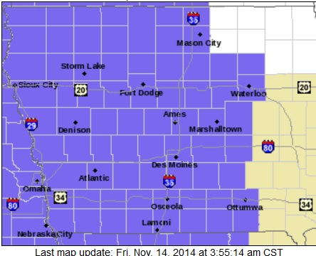
* TIMING OR SHORT TERM TRENDS…SNOW WILL SPREAD INTO WESTERN IOWA BY SUNRISE…AND OVER THE REST OF THE STATE BY NOON.
* STORM TOTAL SNOW/ICE ACCUMULATIONS…AN ACCUMULATION OF 2 TO 3 INCHES OF SNOW IS EXPECTED WITH SOME LOCAL AMOUNTS TO 4 INCHES.
* WINDS/VISIBILITY…VISIBILITY WILL BE REDUCED TO AROUND A MILE OR LESS AT TIMES. WINDS WILL BE SOUTHEAST AT 5 TO 15 MPH.
* IMPACTS…ROADWAYS WILL BECOME SLICK IN PLACES. WITH THE LIGHT CONSISTENCY OF THE SNOW…DRIFTING WILL OCCUR IN OPEN AREAS.
PRECAUTIONARY/PREPAREDNESS ACTIONS…
A WINTER WEATHER ADVISORY FOR SNOW MEANS THAT PERIODS OF SNOW WILL CAUSE PRIMARILY TRAVEL DIFFICULTIES. BE PREPARED FOR SNOW COVERED ROADS AND LIMITED VISIBILITIES…AND USE CAUTION WHILE DRIVING.
353 AM CST FRI NOV 14 2014
…WINTER WEATHER ADVISORY IN EFFECT FROM 9 AM TO 9 PM CST SATURDAY…
EARLY THIS MORNING…MOSTLY CLEAR. COLDER. NORTHWEST WIND NEAR 10 MPH.
TODAY...MOSTLY SUNNY. HIGH IN THE UPPER 20S. NORTHWEST WIND NEAR 5 MPH SHIFTING TO THE SOUTH IN THE AFTERNOON.
TONIGHT…MOSTLY CLOUDY THEN BECOMING PARTLY CLOUDY BEFORE MIDNIGHT AND EARLY MORNING THEN BECOMING MOSTLY CLOUDY. LOW 10 TO 15. SOUTHEAST WIND AROUND 5 MPH.
SATURDAY…A CHANCE OF SNOW BEFORE NOON. SNOW IN THE AFTERNOON. SNOW ACCUMULATION AROUND 2 INCHES. HIGH AROUND 30. SOUTHEAST WIND 5 TO 10 MPH. CHANCE OF SNOW NEAR 100 PERCENT.
SATURDAY NIGHT…MOSTLY CLOUDY. SNOW LIKELY THROUGH MIDNIGHT…THEN A SLIGHT CHANCE OF SNOW AFTER MIDNIGHT. LIGHT SNOW ACCUMULATIONS POSSIBLE. LOW AROUND 10. WEST WIND 5 TO 15 MPH. CHANCE OF SNOW 70 PERCENT.
SUNDAY…SUNNY. HIGH IN THE MID 20S. WEST WIND 10 TO 15 MPH WITH GUSTS TO AROUND 25 MPH.
SUNDAY NIGHT AND MONDAY...MOSTLY CLOUDY. BREEZY. LOW AROUND 10. HIGH IN THE LOWER 20S.
Scattered flurries are flying across much of the state, but no accumulation of snow is expected. A more significant snow event is coming over the weekend, according to National Weather Service Meteorologist Craig Cogill. “As we move into Saturday and Saturday night, we are going to see a system move through the Midwest producing snow across the entire state of Iowa, generally 1 to 3 inches,” Cogill said. “The good thing is there will be very little wind with the snowfall, so it shouldn’t have too big of an impact.” The weekend snowfall will likely stick around for a while, as temperatures are not expected to climb above freezing anytime too soon.
“We are going to see the cold weather stick around into next week, really little relief seen in any way of warming up,” Cogill said. Prior to Saturday’s snow, the forecast calls for mostly clear conditions tonight (Thursday), with lows across the state ranging from zero to the mid-teens. Friday will be sunny with highs in the 20s to low 30s.
(Radio Iowa)
356 AM CST THU NOV 13 2014
EARLY THIS MORNING…MOSTLY CLOUDY. SCATTERED FLURRIES. NORTHWEST WIND 10 TO 15 MPH WITH GUSTS TO AROUND 25 MPH.
TODAY…PARTLY SUNNY. HIGH IN THE MID 20S. NORTHWEST WIND 10 TO 15 MPH.
TONIGHT…MOSTLY CLEAR. LOW 5 TO 10 ABOVE. NORTHWEST WIND 5 TO 10 MPH.
FRIDAY…SUNNY UNTIL LATE AFTERNOON THEN BECOMING PARTLY SUNNY. HIGH IN THE MID 20S. NORTHWEST WIND NEAR 5 MPH SHIFTING TO THE SOUTHWEST IN THE AFTERNOON.
FRIDAY NIGHT…MOSTLY CLOUDY. LOW 15 TO 20. SOUTHEAST WIND NEAR 5 MPH.
SATURDAY…CLOUDY. A CHANCE OF SNOW IN THE MORNING…THEN SNOW IN THE AFTERNOON. LIGHT SNOW ACCUMULATIONS POSSIBLE. HIGH IN THE LOWER 30S. SOUTH WIND 5 TO 10 MPH. CHANCE OF SNOW 80 PERCENT.
SATURDAY NIGHT…CLOUDY WITH A 50 PERCENT CHANCE OF SNOW. LOW 10 TO 15.
SUNDAY AND SUNDAY NIGHT…PARTLY CLOUDY. HIGH IN THE MID 20S. LOW 10 TO 15.
The KJAN listening area forecast and weather info. for Atlantic.

Podcast: Play in new window | Download (1.1MB)
Subscribe: RSS
340 AM CST WED NOV 12 2014
EARLY THIS MORNING…MOSTLY CLOUDY. NORTHWEST WIND 10 TO 15 MPH WITH GUSTS TO AROUND 25 MPH.
TODAY…MOSTLY SUNNY. SCATTERED FLURRIES IN THE AFTERNOON. HIGH IN THE LOWER 20S. NORTHWEST WIND AROUND 15 MPH WITH GUSTS TO AROUND 25 MPH.
TONIGHT…MOSTLY CLOUDY UNTIL EARLY MORNING THEN BECOMING PARTLY CLOUDY. SCATTERED FLURRIES IN THE EVENING. LOW AROUND 15. NORTHWEST WIND 10 TO 15 MPH.
THURSDAY…MOSTLY SUNNY. HIGH IN THE UPPER 20S. NORTHWEST WIND 10 TO 15 MPH.
THURSDAY NIGHT…MOSTLY CLEAR. LOW 5 TO 10 ABOVE. NORTHWEST WIND 5 TO 10 MPH.
FRIDAY...SUNNY. HIGH AROUND 30. NORTHWEST WIND AROUND 5 MPH SHIFTING TO THE SOUTHWEST IN THE AFTERNOON.
FRIDAY NIGHT…MOSTLY CLOUDY. NOT AS COLD. LOW 15 TO 20.
SATURDAY…CLOUDY. A CHANCE OF SNOW IN THE MORNING…THEN SNOW LIKELY IN THE AFTERNOON. LIGHT SNOW ACCUMULATIONS POSSIBLE. HIGH IN THE LOWER 30S. CHANCE OF SNOW 60 PERCENT.
The area’s first snowfall of the season wasn’t too impressive, but the drop in temperature was. Atlantic topped out at 61-degrees during the mid-day hours on Monday, but by 3-p.m., the temperature had plunged almost 20 degrees, and by 5-p.m. we were at 33 here at the KJAN studios, your official National Weather Service reporting site for Atlantic. Our 24-hour low at 7-a.m. today, was 18.
Snowfall overnight included .3″ (three-tenths of an inch) at KJAN. The National Weather Service says Denison and Carroll both reported one-half inch of snow, while Jefferson recorded eight-tenths of an inch. Rockwell City had one-inch of snow.
Weather information for Atlantic and the KJAN listening area.
Podcast: Play in new window | Download (998.0KB)
Subscribe: RSS


