
Light snow is expected to persist in across northern into portions of western Iowa today light accumulations of 1 to 4 inches will be possible with the highest amounts near the Minnesota border. The light precipitation is expected to end across much of Iowa tonight with a slow moderation in temperatures into Christmas Day. Christmas is expected to have good weather with temperatures well above normal along with partly sunny skies. The system on Friday is only expected to affect far northwest Iowa.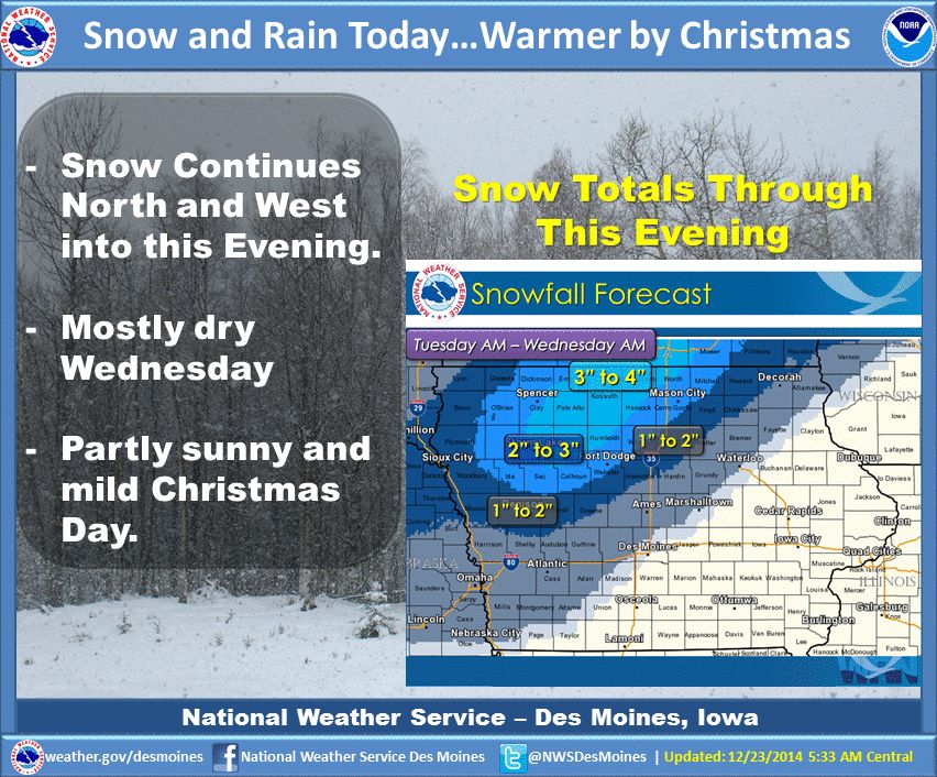
Today Rain and snow likely, becoming all snow after 11am. Cloudy, with a high near 37. North northwest wind 8 to 14 mph, with gusts as high as 18 mph. Chance of precipitation is 60%. Total daytime snow accumulation of less than one inch possible.
Tonight Snow likely, mainly before 2am. Cloudy, with a low around 30. Blustery, with a north northwest wind 14 to 16 mph, with gusts as high as 26 mph. Chance of precipitation is 70%. New snow accumulation of less than a half inch possible.
Wednesday Cloudy, with a high near 34. Breezy, with a north northwest wind 10 to 17 mph, with gusts as high as 25 mph.
Wednesday Night Mostly cloudy, with a low around 25. West northwest wind 7 to 9 mph becoming south southwest after midnight.
Christmas Day Mostly sunny, with a high near 42. South wind 10 to 13 mph, with gusts as high as 21 mph.
Thursday Night Mostly cloudy, with a low around 31.
Friday A slight chance of rain and snow. Mostly cloudy, with a high near 37. Chance of precipitation is 20%.
AREA COUNTIES: AUDUBON-GUTHRIE-DALLAS-CASS-ADAIR-MADISON-ADAMS-UNION-
TAYLOR-RINGGOLD….
TODAY AND TONIGHT: NO HAZARDOUS WEATHER IS EXPECTED AT THIS TIME.
TUESDAY THROUGH SUNDAY… RAIN WILL CHANGE TO SNOW EARLY TUESDAY…CONTINUING INTO WEDNESDAY. TOTAL SNOW ACCUMULATIONS OF 1 TO 2 INCHES WILL BE POSSIBLE. WINDS WILL INCREASE TUESDAY AND WEDNESDAY…WHICH MAY COMBINE WITH FALLING SNOW TO REDUCE VISIBILITIES.
ADDITIONAL ACCUMULATING SNOWFALL WILL BE POSSIBLE FRIDAY. HOWEVER…THERE ARE STILL SOME UNCERTAINTIES WITH LOCATION OF HIGHER SNOW AMOUNTS.
The Freese-Notis weather forecast for the KJAN listening area, and weather information for Atlantic.

Podcast: Play in new window | Download (1.2MB)
Subscribe: RSS
Today: Rain. Temperature falling to around 39 by 8am. South southeast wind 6 to 15 mph, with gusts as high as 21 mph. Chance of precipitation is 90%. New precipitation amounts between a tenth and quarter of an inch possible.
Tonight: Rain before 1am, then rain and snow likely. Low around 31. Southeast wind 5 to 9 mph becoming northwest after midnight. Chance of precipitation is 80%. Little or no snow accumulation expected.
Tuesday: Snow likely before noon, then a chance of rain and snow between noon and 3pm, then a chance of snow after 3pm. Cloudy, with a high near 35. Breezy, with a northwest wind 8 to 16 mph, with gusts as high as 22 mph. Chance of precipitation is 60%. New snow accumulation of less than one inch possible.
Tue. Night: A 20 percent chance of snow before midnight. Cloudy, with a low around 25. Blustery, with a north northwest wind 14 to 17 mph, with gusts as high as 25 mph.
Wednesday: Mostly cloudy, with a high near 33. Breezy.
Wed. Night: Mostly cloudy, with a low around 25.
Christmas Day: Mostly sunny, with a high near 40.
Tonight: Cloudy w/patchy fog & periods of rain. Low around 39. S @ 15-25. New precipitation amounts of less than a tenth of an inch possible.
Monday: Cloudy & breezy w/an 80% chance of rain thru 10- am. High near 45. S/SE @ 10-20 w/gusts to around 25. New precipitation amounts of less than a tenth of an inch possible.
Mon. Night: Cloudy w/a 20% chance of snow after 3-am. Low around 29.
Tuesday: Cloudy & breezy w/ a 20% chance of snow early & a rain-snow mix during the afternoon. High 36. NW @ 5-15mph w/gusts to near 25.
Wednesday: Mostly cloudy & breezy. High near 34.
Wednesday Night: Mostly cloudy, with a low around 24.
Christmas Day: Partly sunny, with a high near 40.
346 AM CST SUN DEC 21 2014
EARLY THIS MORNING…CLOUDY. PATCHY FOG. SOUTH WIND 10 TO 15 MPH.
TODAY…CLOUDY. PATCHY FOG IN THE MORNING. A 20 PERCENT CHANCE OF LIGHT RAIN AND DRIZZLE LATE IN THE AFTERNOON. BREEZY. HIGH IN THE LOWER 40S. SOUTH WIND 10 TO 20 MPH.
TONIGHT…CLOUDY…BREEZY. A CHANCE OF LIGHT RAIN THROUGH MIDNIGHT…THEN RAIN AFTER MIDNIGHT. LOW IN THE UPPER 30S. SOUTH WIND 15 TO 20 MPH. CHANCE OF RAIN 80 PERCENT.
MONDAY…CLOUDY. A CHANCE OF RAIN IN THE MORNING…THEN A SLIGHT CHANCE OF RAIN IN THE AFTERNOON. HIGH IN THE MID 40S. SOUTHWEST WIND 10 TO 15 MPH WITH GUSTS TO AROUND 25 MPH. CHANCE OF RAIN 50 PERCENT.
MONDAY NIGHT…CLOUDY. A 20 PERCENT CHANCE OF LIGHT SNOW AFTER MIDNIGHT. LOW AROUND 30. WEST WIND 5 TO 15 MPH.
TUESDAY…CLOUDY. A SLIGHT CHANCE OF LIGHT SNOW IN THE MORNING…THEN A SLIGHT CHANCE OF LIGHT RAIN AND LIGHT SNOW IN THE AFTERNOON. BREEZY…COLDER. HIGH IN THE MID 30S. NORTHWEST WIND 10 TO 20 MPH WITH GUSTS TO AROUND 30 MPH. CHANCE OF PRECIPITATION 20 PERCENT.
WEDNESDAY…MOSTLY CLOUDY. BREEZY. HIGH IN THE LOWER 30S.
…EXPECT ICY PATCHES ON ROADWAYS AND WALKWAYS THIS MORNING…
AREAS OF FREEZING DRIZZLE AND VERY LIGHT SNOW HAVE CREATED ICY
PATCHES ON ROADWAYS AND WALKWAYS THIS MORNING. TAKE EXTRA
PRECAUTIONS IF VENTURING OUTDOORS EARLY THIS MORNING. THE
PRECIPITATION IS EXPECTED TO DIMINISH AFTER 10 AM.
Today: Patchy fog before 9am. Otherwise, cloudy, with a high near 35. South wind around 10 mph.
Tonight: A chance of drizzle after midnight. Patchy fog after midnight. Otherwise, cloudy, with a low around 32. South wind 5 to 10 mph.
Sunday: A chance of drizzle. Cloudy, with a high near 43. South wind 5 to 15 mph, with gusts as high as 20 mph.
Sunday Night: Rain likely, mainly after midnight. Cloudy, with a low around 38. Breezy, with a south wind 15 to 20 mph, with gusts as high as 25 mph. New precipitation amounts of less than a tenth of an inch possible.
Monday: A moderate chance of rain. Cloudy, with a high near 43. South southwest wind 10 to 15 mph becoming west in the afternoon. Winds could gust as high as 20 mph. New precipitation amounts of less than a tenth of an inch possible.
Tuesday: A 30 percent chance of snow. Cloudy, with a high near 35. Breezy.
Wednesday: Mostly cloudy, with a high near 32. Windy.
Podcast: Play in new window | Download (304.5KB)
Subscribe: RSS
The Freese-Notis weather forecast for the KJAN listening area and weather information for Atlantic.
Podcast: Play in new window | Download (920.5KB)
Subscribe: RSS
EARLY THIS MORNING…CLOUDY. SCATTERED FLURRIES OR PATCHY FREEZING DRIZZLE. NO ICE ACCUMULATION. SOUTH WIND AROUND 5 MPH.
TODAY…CLOUDY. HIGH IN THE LOWER 30S. SOUTH WIND NEAR 10 MPH.
TONIGHT…CLOUDY. PATCHY FOG AFTER MIDNIGHT. PATCHY FREEZING DRIZZLE AFTER MIDNIGHT. NO ICE ACCUMULATION. LOW IN THE UPPER 20S. SOUTH WIND AROUND 5 MPH.
SATURDAY…CLOUDY. PATCHY FOG THROUGH MID MORNING. HIGH IN THE UPPER 30S. SOUTH WIND 5 TO 10 MPH.
SATURDAY NIGHT…CLOUDY. PATCHY DRIZZLE THROUGH THE NIGHT. LOW IN THE LOWER 30S. SOUTH WIND 5 TO 10 MPH.
SUNDAY…CLOUDY. PATCHY DRIZZLE. HIGH IN THE LOWER 40S. SOUTH WIND 10 TO 15 MPH.
SUNDAY NIGHT…CLOUDY. A CHANCE OF RAIN THROUGH MIDNIGHT…THEN RAIN LIKELY AFTER MIDNIGHT. LOW IN THE MID 30S. CHANCE OF RAIN 70 PERCENT.
MONDAY...RAIN LIKELY. HIGH IN THE LOWER 40S. CHANCE OF RAIN 70 PERCENT.


