
337 AM CDT THU MAY 7 2015
EARLY THIS MORNING…CLOUDY WITH SCATTERED THUNDERSTORMS. BREEZY. SOUTH WIND 15 TO 20 MPH WITH GUSTS TO AROUND 30 MPH. CHANCE OF THUNDERSTORMS 50 PERCENT.
TODAY…CLOUDY. NUMEROUS THUNDERSTORMS IN THE MORNING…THEN SCATTERED THUNDERSTORMS IN THE AFTERNOON. BREEZY. HIGH IN THE MID 70S. SOUTH WIND 15 TO 20 MPH WITH GUSTS TO AROUND 30 MPH. CHANCE OF THUNDERSTORMS 70 PERCENT.
TONIGHT...MOSTLY CLOUDY. THUNDERSTORMS LIKELY THROUGH MIDNIGHT. THEN A CHANCE OF THUNDERSTORMS AFTER MIDNIGHT. LOW IN THE UPPER 50S. SOUTHWEST WIND 5 TO 15 MPH SHIFTING TO THE NORTHWEST 5 TO 10 MPH AFTER MIDNIGHT. CHANCE OF THUNDERSTORMS 70 PERCENT.
FRIDAY…MOSTLY CLOUDY. A 20 PERCENT CHANCE OF THUNDERSTORMS UNTIL LATE AFTERNOON. HIGH AROUND 70. NORTH WIND 5 TO 10 MPH.
FRIDAY NIGHT…MOSTLY CLOUDY. A SLIGHT CHANCE OF THUNDERSTORMS THROUGH MIDNIGHT…THEN A CHANCE OF THUNDERSTORMS AFTER MIDNIGHT. LOW IN THE MID 50S. NORTHEAST WIND 5 TO 10 MPH. CHANCE OF THUNDERSTORMS 30 PERCENT.
SATURDAY…MOSTLY CLOUDY WITH A 20 PERCENT CHANCE OF THUNDERSTORMS. HIGH AROUND 70. NORTHEAST WIND 10 TO 15 MPH.
SATURDAY NIGHT…THUNDERSTORMS. LOW IN THE UPPER 50S. CHANCE OF THUNDERSTORMS 80 PERCENT.
SUNDAY…CLOUDY WITH A 50 PERCENT CHANCE OF THUNDERSTORMS. HIGH IN THE MID 70S.
The Freese-Notis weather forecast for Atlantic & the KJAN listening area, and weather info. for Atlantic.

Podcast: Play in new window | Download (1,005.0KB)
Subscribe: RSS
337 AM CDT WED MAY 6 2015
EARLY THIS MORNING…MOSTLY CLOUDY WITH ISOLATED THUNDERSTORMS. SOUTH WIND 5 TO 10 MPH. CHANCE OF THUNDERSTORMS 20 PERCENT.
TODAY…CLOUDY…BREEZY. SHOWERS LIKELY AND ISOLATED THUNDERSTORMS IN THE MORNING…THEN THUNDERSTORMS LIKELY IN THE AFTERNOON. HIGH IN THE LOWER 70S. SOUTH WIND 10 TO 20 MPH WITH GUSTS TO AROUND 35 MPH. CHANCE OF PRECIPITATION 60 PERCENT.
TONIGHT…CLOUDY. SCATTERED THUNDERSTORMS UNTIL EARLY MORNING. THEN THUNDERSTORMS LIKELY EARLY IN THE MORNING. BREEZY. LOW IN THE LOWER 60S. SOUTH WIND 15 TO 20 MPH WITH GUSTS TO AROUND 30 MPH. CHANCE OF THUNDERSTORMS 70 PERCENT.
THURSDAY…THUNDERSTORMS LIKELY. BREEZY. HIGH IN THE MID 70S. SOUTH WIND 15 TO 20 MPH WITH GUSTS TO AROUND 30 MPH. CHANCE OF THUNDERSTORMS 70 PERCENT.
THURSDAY NIGHT…MOSTLY CLOUDY WITH A 50 PERCENT CHANCE OF THUNDERSTORMS. LOW IN THE MID 50S. SOUTHWEST WIND 10 TO 15 MPH WITH GUSTS TO AROUND 25 MPH SHIFTING TO THE WEST 5 TO 10 MPH AFTER MIDNIGHT.
FRIDAY…MOSTLY CLOUDY WITH A 20 PERCENT CHANCE OF THUNDERSTORMS. HIGH IN THE UPPER 60S. NORTH WIND 5 TO 10 MPH.
SATURDAY…MOSTLY CLOUDY WITH A 30 PERCENT CHANCE OF THUNDERSTORMS. HIGH IN THE UPPER 60S.
The Freese-Notis forecast for Atlantic & the KJAN listening area, and weather information specifically for Atlantic.
Podcast: Play in new window | Download (1.2MB)
Subscribe: RSS
Early This Morning: Cloudy with isolated thunderstorms. South wind near 10 mph. Chance of thunderstorms 20 percent.
Today: Mostly cloudy. Scattered showers in the morning. Isolated thunderstorms in the late morning and early afternoon. High in the mid 70s. South wind near 10 mph. Chance of precipitation 50 percent.
Tonight: Partly cloudy through midnight then becoming mostly cloudy. A 20 percent chance of thunderstorms. Low in the lower 60s. Southeast wind around 10 mph.
Wednesday: A chance of thunderstorms in the morning…then thunderstorms likely in the afternoon. Breezy. High in the mid 70s. Southeast wind 10 to 20 mph shifting to the south 20 to 25 mph in the afternoon. Chance of thunderstorms 70 percent.
Wednesday Night: Thunderstorms…breezy. Low in the mid 60s. South wind 15 to 20 mph with gusts to around 30 mph. Chance of thunderstorms 80 percent.
Thursday: Thunderstorms likely. Breezy. High in the mid 70s. South wind 15 to 20 mph with gusts to around 30 mph. Chance of thunderstorms 70 percent.
The state climatologist says April ended up a warmer than usual month. Harry Hillaker says there were several warm periods throughout the month. “Especially the middle part of the month and then the last three or four days of the month,” Hillaker says. He says the warmer parts of the month and a warm stretch back in March kind of got spring going a little earlier than normal in the state.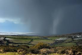
While the month was warmer than normal, the warmest day was on April 1st when Little Sioux hit 88 degrees. “Kind of ironic that we had a 90-degree reading at Sioux City way back on March 16th and haven’t reached that 90-degree mark since then. On the colder extreme, 19-degrees was the lowest temperature we saw during April. It came back on April 4th, Elkader and Bell Plaine had that 19-degree mark,” according to Hillaker.
April 1st was also the warmest day of the month in Atlantic, when we topped at 82 degrees. The average High in Atlantic during April, was 63.6-degrees, which was 1.4-degrees warmer than normal. The average Low for the month was 36.6-degrees, which was just shy of the 37.4-degree norm.
Hillaker says the rainfall amounts weren’t anything out of the ordinary. “Right about usual as least as far as the statewide average goes,” Hillaker says. “A few areas were unusually wet — mainly from the west-central across to the north-central part of the state. Some areas have been very dry, the far northwest corner as well as part of southeastern Iowa as well. But overall, averaging pretty close to normal for April precipitation.”
Rainfall in Atlantic for the month of April amounted to 3.97-inches. Which was slightly more than one-half inch above normal. Hillaker says there wasn’t much severe weather in April.
(Radio Iowa/KJAN weather records)
Large hail, high winds and heavy rain came with last (Sunday) night’s thunderstorms that rumbled across much of Iowa. Meteorologist Brad Small, at the National Weather Service office in Johnston, says parts of northwest Iowa report tennis ball-sized hail while wind gusts near 60 miles an hour were reported in north-central Iowa near Algona in Kossuth County.
“We had some reports of inch hail starting in northwest Iowa near the West Bend area,” Small says. “It progressed farther south and east into the evening. The biggest was near the town of Manson in Calhoun County which had anywhere from an inch up to two-and-a-half inch hail. We had some reports of broken windows there, too.” Small says more thunderstorms are likely later today and practically every day this week.
“Of and on through much of the week, we’ll have some storms, mainly tonight more than today, and there may be a break late Tuesday and Tuesday night,” Small says. “Other than that, the forecast for the week and into next weekend looks stormy with several periods of showers and thunderstorms.” At least one tornado was reported in eastern Nebraska last night, along with some areas getting three inches of rain.
(Radio Iowa)
The Freese-Notis forecast for the KJAN listening area and weather info. for Atlantic.
Podcast: Play in new window | Download (1.1MB)
Subscribe: RSS
Early This Morning: Cloudy with scattered light showers and isolated thunderstorms. North wind 5 to 15 mph. Chance of precipitation 50 percent.
Today: Cloudy…cooler. A slight chance of light showers and isolated thunderstorms through mid morning. A chance of thunderstorms early in the afternoon…then thunderstorms likely late in the afternoon. High in the upper 60s. Northeast wind 10 to 15 mph with gusts to around 25 mph. Chance of precipitation 70 percent.
Tonight: Thunderstorms in the evening…then thunderstorms likely before midnight and early morning. A chance of thunderstorms early in the morning. Low in the upper 50s. East wind 5 to 15 mph. Chance of thunderstorms 90 percent.
Tuesday: Partly sunny. A chance of thunderstorms through mid morning…then a slight chance of thunderstorms in the late morning and afternoon. High in the upper 70s. South wind 5 to 15 mph. Chance of thunderstorms 40 percent.
Tuesday Night: Partly cloudy through midnight then becoming mostly cloudy. A 20 percent chance of thunderstorms. Low in the lower 60s. Southeast wind 10 to 15 mph.
Wednesday: Thunderstorms likely. Breezy. High in the mid 70s. South wind 10 to 15 mph increasing to 20 to 25 mph in the afternoon. Chance of thunderstorms 70 percent.
MONONA-HARRISON-SHELBY-POTTAWATTAMIE-MILLS-MONTGOMERY-FREMONT-PAGE-COUNTIES.
405 AM CDT SUN MAY 3 2015
TODAY AND TONIGHT: THERE IS A CHANCE OF THUNDERSTORMS THIS AFTERNOON…MAINLY ACROSS NORTHEAST NEBRASKA AS A COLD FRONT PUSHES INTO THE AREA. STORMS WILL THEN LIKELY EXPAND OR DEVELOP TO THE SOUTH AND EAST OVER THE REST OF EASTERN NEBRASKA AND SOUTHWEST IOWA. SOME STORMS COULD BE SEVERE. LARGE HAIL AND DAMAGING WINDS WOULD BE THE MAIN HAZARDS.
THE COVERAGE AND INTENSITY OF STORMS SHOULD DECREASE AFTER
MIDNIGHT.
SPOTTERS: PLEASE PASS ANY REPORTS OF HAIL OR STRONG WIND ACTIVITY TO THE NATIONAL WEATHER SERVICE.


