
352 AM CDT MON JUN 29 2015
EARLY THIS MORNING…MOSTLY CLEAR. PATCHY FOG. NORTHWEST WIND NEAR 10 MPH.
TODAY…SUNNY. PATCHY FOG THROUGH MID MORNING. HIGH IN THE MID 80S. NORTHWEST WIND 5 TO 15 MPH.
TONIGHT…PARTLY CLOUDY. A 20 PERCENT CHANCE OF THUNDERSTORMS UNTIL EARLY MORNING. LOW IN THE LOWER 60S. WEST WIND 5 TO 10 MPH.
TUESDAY…MOSTLY SUNNY. HIGH IN THE MID 80S. NORTHWEST WIND 5 TO 10 MPH.
TUESDAY NIGHT…MOSTLY CLOUDY WITH A 50 PERCENT CHANCE OF THUNDERSTORMS. LOW IN THE MID 60S. EAST WIND 5 TO 10 MPH.
WEDNESDAY…PARTLY SUNNY WITH A 50 PERCENT CHANCE OF THUNDERSTORMS. HIGH IN THE LOWER 80S. EAST WIND 5 TO 10 MPH.
THURSDAY…PARTLY SUNNY WITH A 40 PERCENT CHANCE OF THUNDERSTORMS. HIGH IN THE UPPER 70S.
(Updated 5:22 AM CDT SUN JUN 28 2015/NWS Des Moines)
TODAY…MOSTLY SUNNY. A CHANCE OF THUNDERSTORMS IN THE MORNING, THEN A SLIGHT CHANCE OF THUNDERSTORMS EARLY IN THE AFTERNOON. HIGH IN THE MID 80S. SOUTHWEST WIND 5 TO 15 MPH SHIFTING TO THE NORTHWEST 10 TO 15 MPH IN THE AFTERNOON. CHANCE OF THUNDERSTORMS 40 PERCENT.
TONIGHT…MOSTLY CLEAR. LOW IN THE LOWER 60S. NORTHWEST WIND 5 TO 15 MPH.
MONDAY…SUNNY. HIGH IN THE MID 80S. NORTHWEST WIND 5 TO 15 MPH.
MONDAY NIGHT…PARTLY CLOUDY. A 20 PERCENT CHANCE OF THUNDERSTORMS THROUGH MIDNIGHT. LOW IN THE MID 60S. WEST WIND 5 TO 10 MPH.
TUESDAY…MOSTLY SUNNY. HIGH IN THE MID 80S. NORTHWEST WIND 5 TO 10 MPH.
TUESDAY NIGHT…MOSTLY CLOUDY WITH A 40 PERCENT CHANCE OF THUNDERSTORMS. LOW IN THE MID 60S.
WEDNESDAY…MOSTLY CLOUDY WITH A 40 PERCENT CHANCE OF THUNDERSTORMS. HIGH IN THE LOWER 80S.
The Freese-Notis (podcast) weather forecast for Atlantic & the KJAN listening area, and weather information for Atlantic.

Podcast: Play in new window | Download (1,011.1KB)
Subscribe: RSS
EARLY THIS MORNING…MOSTLY CLOUDY WITH A 40 PERCENT CHANCE OF THUNDERSTORMS. NORTHEAST WIND 5 TO 10 MPH.
TODAY…MOSTLY CLOUDY WITH A 40 PERCENT CHANCE OF THUNDERSTORMS. HIGH IN THE UPPER 70S. NORTH WIND 5 TO 10 MPH.
TONIGHT…MOSTLY CLEAR. A 20 PERCENT CHANCE OF THUNDERSTORMS IN THE EVENING. LOW IN THE UPPER 50S. NORTH WIND NEAR 10 MPH.
SATURDAY…MOSTLY SUNNY. HIGH IN THE UPPER 70S. NORTH WIND NEAR 5 MPH.
SATURDAY NIGHT…PARTLY CLOUDY. A 20 PERCENT CHANCE OF THUNDERSTORMS AFTER MIDNIGHT. LOW IN THE LOWER 60S. SOUTHWEST WIND NEAR 5 MPH.
SUNDAY…MOSTLY SUNNY. A CHANCE OF THUNDERSTORMS IN THE MORNING, THEN A SLIGHT CHANCE OF THUNDERSTORMS IN THE AFTERNOON. HIGH IN THE LOWER 80S. SOUTHWEST WIND 5 TO 10 MPH SHIFTING TO THE NORTHWEST 10 TO 15 MPH IN THE AFTERNOON. CHANCE OF THUNDERSTORMS 40 PERCENT.
MONDAY…SUNNY. HIGH IN THE LOWER 80S.
The Shelby County Emergency Management Agency, Thursday afternoon issued a statement in response to questions the public may have had with regard to Wednesday night’s storms. Operations Officer Jason Wickizer said “Staff were monitoring weather prior to Tornado Watch being issued. As soon as the Tornado Watch was issued at 6:20-p.m., the Emergency Management Coordinator and Operations Officer were out meeting the storm as it rapidly built just Northwest of Harlan.”
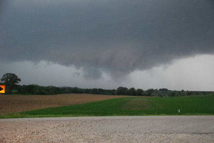
Storm photo from the Shelby County EMA Facebook page
He went on to say “Area Fire Departments were advised by pager of the Tornado Watch by 6:23-p.m. Sheriff’s Deputies were also assisting with monitoring the same Storm Cell. Due to the rapid growth Harlan Police Department assisted local residents by opening shelters, and monitoring the weather. At 6:28-p.m., a Severe Thunderstorm Warning was received.”
Wickizer said also “Spotters from all area Fire Departments were also placed in the field at pre-determined locations to observe the storm as it tracked through the county this was completed by 6:34-p.m. Once observations of the storm cell were made National Weather Service personnel were in touch with Shelby County EMA/911 Dispatchers relaying real time radar interpretations of what they were seeing on radar.”
He added that the “National Weather Service confirmed what field observers were seeing and that was ‘wide area rotation.’ As the Storm Cell continued South – South East it developed a prominent lowering or “Wall Cloud” that was rotating. This was reported to Shelby County EMA/911 Dispatchers at 6:50-p.m. by EMA Operations Officer, with the EMA Coordinator calling for the Sirens to be activated in Harlan.
As the storm continued to track SSE a Deputy reported a brief touchdown of a tornado on Redbud Road at 7:02-p.m. Due to funnel development and history of [the] storm, [the] EMA Coordinator had Shelby County EMA/911 Dispatchers activate the Sirens in Elk Horn. By 7:49-p.m., the storm exited the county [and] personnel returned to normal duties.”
Wickizer said “The Storm Cell in question had more than 4 trained Public Safety Spotters following it across the county keeping it in visual contact at all times. Public Safety Spotters, and Fire Departments were monitoring and relaying information through communications to keep the public warned as early as possible.”
In response to questions from some residents who said they could not hear the sirens in their homes, Wickizer said “Sirens are an outdoor warning signal, not designed to be heard in your home. Inside warnings should come in the form of a NOAA weather radio, Code Red Emergency Communications Network (cell/telephone warning), Radio, and Television Media.” Another question people have asked is “Why did this storm surprise us, it seems to have developed quickly?”
Wickizer said “The Tornado Watch actually means when weather conditions are favorable for the rapid development of severe thunderstorms that are capable of producing tornadoes. A tornado watch therefore implies that it is also a severe thunderstorm watch. A tornado watch must not be confused with a tornado warning. In most cases, the potential exists for large hail and/or damaging winds in addition to tornadoes. A watch does not mean that the severe weather is actually occurring, only that atmospheric conditions have created a significant risk for it.”
“As we are all aware the weather rapidly changed once the watch developed. We encourage all citizens of Shelby County to sign up for Code Red, and remember that coming soon we will be switching from Code Red to the “Alert Iowa” system which is a statewide notification system.”
Wicker mentioned that they will be advertising when signups for “Alert Iowa” are ready to begin, but until that time Code Red, will remain in the Shelby County Emergency Communications Network.
He also mentioned how severe weather has become a “large industry” for “Spotters”, “Chasers”, “Tour Guides” and “Researchers.” Wickizer said they “Are seeing an abundance of people on the roadways during storms that are parking in the roadway, and placing weather monitoring devices in the travel portions of the roadway. We ask the public to be aware of this during storms.”
As an example, he said Wednesday night, while spotting along county road F-58, an Emergency Management employee had to drive around a spotter that parked his car in the middle of the roadway with no lights on filming the storm cell as it crossed the road. An adjacent County Emergency Manager came upon another spotter that deployed an instrument in the travel portion of a roadway.
Wickizer said “Several of these individuals will drive fast, and are not watching the road so please remain cautious if you happen to be driving during a storm.” And, as a final note, he said “Storm spotters in Shelby County are Public Safety Officials – if you are approached by someone claiming to be a “Storm Spotter” they should be in an Official Vehicle, or have Department Identification. If you are approached by someone that does not meet these criteria they are more likely than not a non-affiliated recreational spotter.”
Several videos and additional bits of information about the storm that hit Shelby County are available on the EMA’s Facebook page. (www.facebook.com/pages/Shelby-County-Emergency-Management/118172524867212?fref=ts)
312 PM CDT THU JUN 25 2015
THE NATIONAL WEATHER SERVICE IN VALLEY, NE., HAS CANCELLED THE FLASH FLOOD WATCH FOR FREMONT AND PAGE COUNTIES, IN SOUTHWEST IOWA.
WARREN IA-MARION IA-WAYNE IA-DALLAS IA-MADISON IA-LUCAS IA-
GUTHRIE IA-MONROE IA-CLARKE IA-POLK IA-APPANOOSE IA-GREENE IA-
1154 AM CDT THU JUN 25 2015
…A FLOOD WARNING REMAINS IN EFFECT UNTIL 400 PM CDT THURSDAY FOR WARREN…MARION…NORTHEASTERN WAYNE…DALLAS…MADISON…LUCAS…NORTHEASTERN GUTHRIE…MONROE…NORTHEASTERN CLARKE…POLK…
APPANOOSE AND SOUTHEASTERN GREENE COUNTIES…
AT 1140 AM CDT…WIDESPREAD HEAVY RAINS…OFTEN IN EXCESS OF FIVE
INCHES FELL OVER THE PAST 24 HOURS FROM CARROLL COUNTY…THROUGH THE SOUTHERN AND WESTERN DES MOINES METRO AREA…INTO MONROE COUNTY. MANUAL OBSERVATIONS REPORTED AS MUCH AS 7.25 INCHES JUST SOUTH OF DAWSON…AND RADAR ESTIMATES SHOW THAT LOCAL AMOUNTS MAY HAVE EXCEED EIGHT INCHES. MANY SECONDARY…AND SOME PRIMARY ROADS CONTINUE TO BE
FLOODED AND CLOSED. SOME ROADS AND BRIDGES HAVE BEEN WASHED OUT.
IN THE DES MOINES METRO AREA…WALNUT CREEK IS CURRENTLY RECEDING AT ALL LOCATIONS WITH NO FURTHER RISES ANTICIPATED.
SOME LOCATIONS THAT WILL EXPERIENCE FLOODING INCLUDE…
DES MOINES…WEST DES MOINES…ANKENY…URBANDALE…JOHNSTON…
CLIVE…INDIANOLA…ALTOONA…WAUKEE…PELLA…NORWALK…PLEASANT
HILL…GRIMES…PERRY…KNOXVILLE…CENTERVILLE…WINTERSET…
OSCEOLA…CHARITON AND ALBIA.
PRECAUTIONARY/PREPAREDNESS ACTIONS…
A FLOOD WARNING MEANS THAT FLOODING IS IMMINENT OR HAS BEEN REPORTED. STREAM RISES WILL BE SLOW AND FLASH FLOODING IS NOT EXPECTED. MOST FLOOD DEATHS OCCUR IN AUTOMOBILES. NEVER DRIVE YOUR VEHICLE INTO AREAS WHERE THE WATER COVERS THE ROADWAY. FLOOD WATERS ARE USUALLY DEEPER THAN THEY APPEAR. JUST ONE FOOT OF FLOWING WATER IS POWERFUL ENOUGH TO SWEEP VEHICLES OFF THE ROAD. WHEN ENCOUNTERING FLOODED ROADS MAKE THE SMART CHOICE…TURN AROUND…DONT DROWN.
FLOOD STATEMENT NATIONAL WEATHER SERVICE DES MOINES IA 1042 AM CDT THU JUN 25 2015 …The Flood Warning has been extended for all or portions of the following rivers in Iowa…Des Moines River…Beaver Creek…Raccoon River…North Raccoon River…South Raccoon River…Middle River… South River…Cedar Creek… Affecting the following counties in Iowa…Dallas…Davis… Greene…Guthrie…Madison…Mahaska…Marion…Polk…Wapello… Warren.
PRECAUTIONARY/PREPAREDNESS ACTIONS… If you encounter a flooded area…turn around and find an alternate route. Turn around…do not drown.
CLIVE, Iowa (AP) – West Des Moines and other Polk County cities are preparing for flooding as rivers and creeks rise past flood stages following heavy rains. The National Weather Service says the Raccoon River is expected to top out at least a half foot above the record level later Thursday. Polk County authorities say floodwater at that West Des Moines spot could wash over Interstate 35, close Iowa Highway 28 and spill into Raccoon River Park.
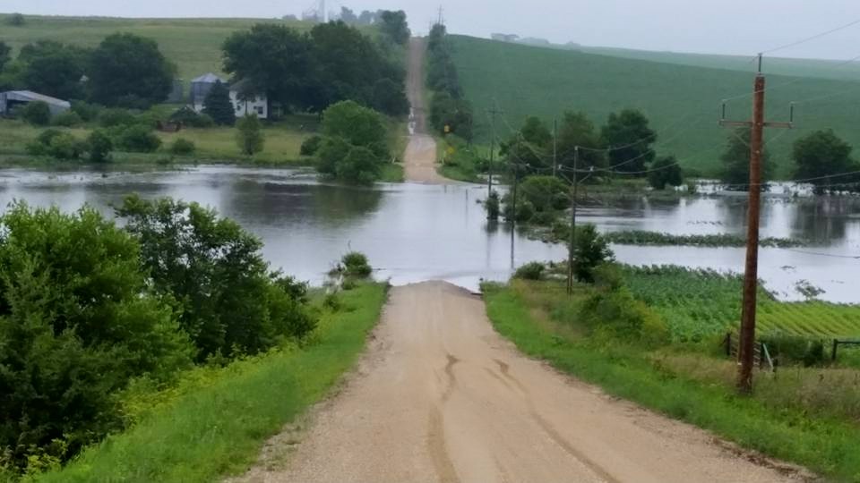
This is the Middle River, east of Casey this morning. (Photo from Adair-Guthrie County EMA)
The Des Moines River is expected to crest nearly 7 feet above flood stage but nearly 5 feet under its Des Moines location record. An apartment complex in Clive was evacuated early Thursday morning as water spilled from North Walnut Creek.
The National Weather Service has issued flood warnings for several Iowa counties.
The National Weather Service reports near-record level flooding was occurring this morning, in Des Moines. Due to widespread rainfall of 3 to 5 inches overnight, with some places receiving over 6 inches of rain, water levels along the Raccoon River, the Des Moines River, and Walnut Creek are reaching near-historic levels.
Water has already covered Grand Avenue and has impacted nearby residences and businesses. There have been numerous reports of road closures, water rescues, and evacuations across parts of the Des Moines metro.
The latest river forecasts across the rest of central Iowa can be found at:
http://water.weather.gov/ahps2/index.php?wfo=DMX
Please note that river forecasts will be changing over the next few hours. Please continue to monitor these forecasts if you live near these flooded areas!!!
Remember that if you come across water and can’t tell how deep it is, TURN AROUND, DON’T DROWN!!! weather.gov.desmoines


