
At least one tornado touched down in rural southern Iowa last (Sunday) night, near the towns of Creston, Cromwell and Williamson. National Weather Service meteorologist Roger Vachalek can’t yet confirm whether there were multiple twisters.
“There may have been just one tornado,” Vachalek says. “We sent out a survey team today to take a look at that. That occurred in Adams County so we’ll have folks out there surveying the damage this morning and we’ll have some results from that later on this afternoon, probably before about 5 o’clock.”
While some crops were torn up and a few farmsteads were hit by the likely tornado, there are no reports of anyone being hurt. “From what we understand, from some of the photos we’ve received that will help us with the survey, it did damage some farms and cut through some fields, so there’s some significant damage,” Vachalek says. “Fortunately, we did not see it go through any major towns or cities last night.”
Before last night’s storms, there had only been 25 tornadoes reported statewide this year, far below the annual average of 46. Last year, there were 55 twisters reported across Iowa. Damage reports were scattered across central and southern Iowa from last night’s bout of severe weather.
“These thunderstorms that developed around the Des Moines metro area and then filled in quickly over the southern counties, did produce a number of large hail reports, some in excess of 1.75 inches, or golf ball-sized or larger,” Vachalek says.
Large hail was reported in the following counties: Adair, Dallas, Marion, Jasper, Taylor and Union. A possible microburst knocked over a semi-truck near Des Moines while Chariton reports winds of almost 60 miles an hour. Vachalek says we’ll see somewhat cooler weather most of this week, with rain possible much of the next five to seven days.
(Radio Iowa)
The Freese-Notis (podcast) weather forecast for Atlantic & the KJAN listening area, and weather information for Atlantic.

Podcast: Play in new window | Download (1,013.0KB)
Subscribe: RSS
DES MOINES, Iowa (AP) – A tornado has ripped through farm fields in southern Iowa as thunderstorms elsewhere in the state dropped heavy rain and loosed hail that approaching the size of baseballs. Thirty-year-old Mike Gillespie told The Des Moines Register that he watched the tornado switch directions and miss his parents’ farm north of the township of Williamson in Adams County late Sunday evening.
The storm tore up fields of corn and other crops and also damaged farm buildings. No injuries have been reported.
The National Weather Service says a preliminary storm survey is set to take place today (Monday) in Adams County, with regard to the severe thunderstorms that passed through the area Sunday evening. At least four tornado events were reported in the county, near the Adair-Adams-Union County lines, with video and photographic evidence of some tornadoes on the ground. Damage was also reported just before 7-p.m., to some rural buildings and other structures near Cromwell, at 120th and Urban Avenue.
In addition to the confirmed tornado on the ground near Cromwell Sunday at about 6:30-p.m., there were numerous reports of hail ranging in size from marbles near Creston, in Union County, to golf ball-sized near New Market, in Taylor County. In east central Iowa’s Jasper County, tennis ball-size hail was reported at around 6:20-p.m., near Monroe. Winds in Lucas County gusted up to nearly 60 miles per Sunday evening, as well.
A survey team will begin their storm damage assessment in southern Adair County this morning and proceed from there, in an effort to determine the track of a tornado or tornadoes.
Today: Mostly sunny. Not as warm. High in the lower 80s. Northeast wind around 5 mph.
Tonight: Partly cloudy with a slight chance of thunderstorms through midnight…then mostly cloudy with a chance of thunderstorms after midnight. Low in the mid 60s. East wind near 5 mph. Chance of thunderstorms 40 percent.
Tuesday: Partly sunny with a 40 percent chance of thunderstorms. High in the lower 80s. Southeast wind near 10 mph.
Tuesday Night: Mostly cloudy with a 40 percent chance of thunderstorms. Low in the mid 60s. Southeast wind 5 to 10 mph.
Wednesday: Mostly cloudy with a 40 percent chance of thunderstorms. High around 80.
Wednesday Night: Mostly cloudy with a 50 percent chance of thunderstorms. Low in the mid 60s.
Thursday: Partly sunny with a 20 percent chance of thunderstorms. High in the upper 70s.
(Will be updated)
8:13-p.m. 1″ diameter hail 4 miles s.w. of Gravity in Taylor County
7:24-p.m. Dime size hail in Orient observed by trained weather spotter
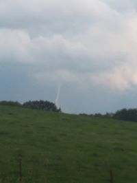
7:04-p.m. Funnel cloud seen 6 miles N/NE of Villisca in Montgomery County
6:52-p.m 1″ diameter hail in Creston (spotter obs.)

Off Hwy 92 between Greenfield & Fontanelle (pics courtesy of Michelle Reinhardt)
6:20-to 6:30-p.m. Numerous funnel cloud or tornado on the ground reports from the public, NE of Prescott, NW of Cromwell in Adams County, and NW of Creston, in Union County
6:34-p.m. 1 1/4″ hail in Glenwood, Mills County.
6:15-p.m. 1″ diameter hail W/NW of Grant in Montgomery County
6:10-p.m. 1 1/4″ hail reported 3 miles w/nw of Orient by trained spotter in Adair Co.
5:50-p.m. Nickel-sized hail in Greenfield reported by Adair County Emergency Mgmt.
Off Hwy 92 w. of Bridgewater
4:20-a.m. 1-inch diameter hail reported 2 miles south/southwest of Panama in Shelby County.
756 PM CDT SUN AUG 2 2015

THE NATIONAL WEATHER SERVICE IN DES MOINES  HAS ISSUED A

* SEVERE THUNDERSTORM WARNING FOR...
  RINGGOLD COUNTY IN SOUTH CENTRAL IOWA...
  NORTHEASTERN TAYLOR COUNTY IN SOUTHWESTERN IOWA...
  SOUTHWESTERN UNION COUNTY IN SOUTH CENTRAL IOWA...
  SOUTHEASTERN ADAMS COUNTY IN SOUTHWESTERN IOWA...

* UNTIL 845 PM CDT

* AT 755 PM CDT...SEVERE THUNDERSTORMS WERE LOCATED ALONG A LINE
  EXTENDING FROM 7 MILES SOUTH OF CRESTON TO NEAR LENOX...MOVING
  SOUTHEAST AT 30 MPH.

  HAZARD...60 MPH WIND GUSTS AND QUARTER SIZE HAIL.

  SOURCE...RADAR INDICATED.

  IMPACT...HAIL DAMAGE TO VEHICLES IS EXPECTED. EXPECT WIND DAMAGE
           TO ROOFS...SIDING AND TREES.

* LOCATIONS IMPACTED INCLUDE...
  MOUNT AYR...LENOX...CLEARFIELD...DIAGONAL...PRESCOTT...BLOCKTON...
  TINGLEY...ARISPE...REDDING...SHANNON CITY...KENT...ELLSTON...
  BENTON...MALOY...DELPHOS...MT AYR MUNICIPAL AIRPORT AND CRESTON
  MUNICIPAL AIRPORT.
742 PM CDT SUN AUG 2 2015
THE NATIONAL WEATHER SERVICE IN DES MOINES HAS ISSUED A
* SEVERE THUNDERSTORM WARNING FOR…
TAYLOR COUNTY IN SOUTHWESTERN IOWA…
SOUTHWESTERN ADAMS COUNTY IN SOUTHWESTERN IOWA…
* UNTIL 830 PM CDT
* AT 741 PM CDT…A SEVERE THUNDERSTORM WAS LOCATED 8 MILES SOUTHEAST OF VILLISCA…OR 11 MILES SOUTHWEST OF CORNING…MOVING SOUTH AT 25 MPH.
HAZARD…60 MPH WIND GUSTS AND QUARTER SIZE HAIL.
SOURCE…RADAR INDICATED.
IMPACT…HAIL DAMAGE TO VEHICLES IS EXPECTED. EXPECT WIND DAMAGE
TO ROOFS…SIDING AND TREES.
* LOCATIONS IMPACTED INCLUDE…
BEDFORD…NEW MARKET…BLOCKTON…GRAVITY…NODAWAY…SHARPSBURG…
CONWAY…ATHELSTAN…LAKE OF THREE FIRES STATE PARK AND BEDFORD
MUNICIPAL AIRPORT.
PRECAUTIONARY/PREPAREDNESS ACTIONS…
FOR YOUR PROTECTION MOVE TO AN INTERIOR ROOM ON THE LOWEST FLOOR OF A
BUILDING.
FREMONT IA-MILLS IA-MONTGOMERY IA-
730 PM CDT SUN AUG 2 2015
…SIGNIFICANT WEATHER ADVISORY FOR WESTERN MONTGOMERY…SOUTHEASTERN
MILLS AND NORTHEASTERN FREMONT COUNTIES UNTIL 830 PM CDT…
AT 730 PM CDT…DOPPLER RADAR WAS TRACKING A STRONG THUNDERSTORM OVER MALVERN…OR 29 MILES SOUTHEAST OF OMAHA…MOVING SOUTHEAST AT 10 MPH.
NICKEL SIZE HAIL AND WINDS IN EXCESS OF 40 MPH WILL BE POSSIBLE WITH THIS STORM.
LOCATIONS IMPACTED INCLUDE…
GLENWOOD…MALVERN…EMERSON…TABOR…RANDOLPH…HASTINGS AND
IMOGENE.
724 PM CDT SUN AUG 02 2015
SEVERE THUNDERSTORM WATCH 464 REMAINS IN EFFECT UNTIL 1100 PM CDT IOWA COUNTIES INCLUDED ARE…
ADAMS APPANOOSE CLARKE DAVIS DECATUR FREMONT HENRY JEFFERSON KEOKUK LEE LUCAS MAHASKA MARION MILLS MONROE MONTGOMERY PAGE POWESHIEK RINGGOLD TAYLOR UNION VAN BUREN WAPELLO WARREN WASHINGTON WAYNE


