
354 AM CDT THU AUG 6 2015
TODAY…PARTLY SUNNY. PATCHY FOG THROUGH MID MORNING. HIGH IN THE LOWER 80S. SOUTH WIND NEAR 10 MPH.
TONIGHT…MOSTLY CLOUDY. A 20 PERCENT CHANCE OF THUNDERSTORMS OVERNIGHT. LOW IN THE UPPER 60S. SOUTH WIND 5 TO 10 MPH.
FRIDAY…MOSTLY SUNNY. HIGH IN THE UPPER 80S. SOUTHWEST WIND 5 TO 10 MPH SHIFTING TO THE NORTHWEST IN THE AFTERNOON.
FRIDAY NIGHT…PARTLY CLOUDY THROUGH MIDNIGHT…THEN MOSTLY CLOUDY WITH A 20 PERCENT CHANCE OF THUNDERSTORMS AFTER MIDNIGHT. LOW IN THE UPPER 60S. NORTHEAST WIND NEAR 10 MPH SHIFTING TO THE SOUTHEAST AFTER MIDNIGHT.
SATURDAY…CLOUDY WITH A 50 PERCENT CHANCE OF THUNDERSTORMS. HIGH IN THE LOWER 80S. SOUTHEAST WIND NEAR 10 MPH.
SATURDAY NIGHT…CLOUDY WITH A 50 PERCENT CHANCE OF THUNDERSTORMS. LOW IN THE UPPER 60S.
SUNDAY…MOSTLY CLOUDY WITH A 50 PERCENT CHANCE OF THUNDERSTORMS. HIGH IN THE LOWER 80S.
The Freese-Notis (podcast) weather forecast for Atlantic & the KJAN listening area, and weather information for Atlantic.

Podcast: Play in new window | Download (1.2MB)
Subscribe: RSS
Today: Mostly cloudy with a 50 percent chance of thunderstorms. High in the upper 70s. East wind 5 to 10 mph.
Tonight: Mostly cloudy then becoming partly cloudy after midnight then becoming mostly cloudy. A 20 percent chance of thunderstorms in the evening. Low in the mid 60s. East wind near 10 mph.
Thursday: Partly sunny. High in the lower 80s. East wind near 5 mph shifting to the southeast in the afternoon.
Thursday Night: Mostly cloudy with a chance of thunderstorms through midnight…then partly cloudy with a slight chance of thunderstorms after midnight. Low in the mid 60s. South wind near 10 mph. Chance of thunderstorms 40 percent.
Friday: Mostly sunny. High in the mid 80s.
Friday Night: Mostly cloudy. Low in the mid 60s.
Saturday: Partly sunny with a 20 percent chance of thunderstorms. High in the mid 80s.
The Freese-Notis (podcast) weather forecast for Atlantic & the KJAN listening area, and weather information for Atlantic.
Podcast: Play in new window | Download (1.2MB)
Subscribe: RSS
CRAWFORD-AUDUBON-CASS-ADAIR-ADAMS-UNION-TAYLOR-RINGGOLD COUNTIES….TUE AUG 4 2015
TODAY AND TONIGHT: THUNDERSTORMS ARE POSSIBLE THROUGHOUT THE DAY INTO THE OVERNIGHT. ALTHOUGH SEVERE WEATHER IS NOT ANTICIPATED…SOME OF THE STRONGER STORMS MAY PRODUCE SMALL HAIL AND BRIEF GUSTY WINDS.
WEDNESDAY THROUGH MONDAY: INTERMITTENT THUNDERSTORM CHANCES CONTINUE THROUGHOUT THE FORECAST PERIOD. STRONG TO SEVERE STORMS MAY BE POSSIBLE THURSDAY EVENING INTO FRIDAY MORNING. AT THIS TIME…THE SEVERE WEATHER THREAT REMAINS LOW FOR THE REST OF THE PERIOD.
.SPOTTER INFORMATION STATEMENT…
SPOTTER ACTIVATION MAY BE NEEDED THURSDAY NIGHT.
CARROLL-GUTHRIE-DALLAS-MADISON COUNTIES:
TODAY AND TONIGHT: NO HAZARDOUS WEATHER IS EXPECTED AT THIS TIME.
WEDNESDAY THROUGH MONDAY: INTERMITTENT THUNDERSTORM CHANCES CONTINUE THROUGHOUT THE FORECAST PERIOD. STRONG TO SEVERE STORMS MAY BE POSSIBLE THURSDAY EVENING INTO FRIDAY MORNING. AT THIS TIME…THE SEVERE WEATHER THREAT REMAINS LOW FOR THE REST OF THE PERIOD.
MONONA-HARRISON-SHELBY-POTTAWATTAMIE-MILLS-MONTGOMERY-FREMONT-PAGE COUNTIES…
601 AM CDT TUE AUG 4 2015
TODAY AND TONIGHT: SCATTERED AND ISOLATED STORMS WILL BE POSSIBLE THROUGH THE DAY AND INTO TONIGHT. A FEW STORMS MAY APPROACH SEVERE LEVELS DURING THIS TIME WITH LARGE HAIL AND DAMAGING WINDS THE PRIMARY HAZARDS.
WEDNESDAY THROUGH MONDAY: THERE IS A CHANCE OF THUNDERSTORMS THROUGH MUCH OF THE WEEK AND INTO THE WEEKEND AS SEVERAL WEATHER IMPULSES MOVE ACROSS THE REGION.
.SPOTTER INFORMATION STATEMENT…
SPOTTER ACTIVATION IS NOT EXPECTED TONIGHT OR TUESDAY…BUT
PLEASE PASS ALONG ANY REPORTS OF LARGE HAIL OR WIND DAMAGE.
Today: Partly sunny with a 20 percent chance of thunderstorms. High in the lower 80s. Southeast wind 5 to 10 mph.
Tonight: Mostly cloudy with a 50 percent chance of thunderstorms. Low in the mid 60s. Southeast wind around 5 mph.
Wednesday: Partly sunny. A chance of thunderstorms in the morning…then a slight chance of thunderstorms in the afternoon. High in the lower 80s. East wind 5 to 10 mph. Chance of thunderstorms 50 percent.
Wednesday Night: Mostly cloudy with a 20 percent chance of thunderstorms. Low in the mid 60s. East wind 5 to 10 mph.
Thursday: Partly sunny. High in the lower 80s.
Thursday Night: Mostly cloudy with a 40 percent chance of thunderstorms. Low in the mid 60s.
Friday: Partly sunny with a 20 percent chance of thunderstorms. High in the lower 80s.
Taken 10 miles south of Fontanelle. One mile south of the Adair-Adams Co. line. 110th and Sycamore. Referred to as “Williamson.”

Photo courtesy Mike Kennon
A National Weather Service survey team has given a preliminary estimate of a tornado Sunday night in Adams county as an EF-1, or “weak.” The 350-yard wide twister packed peak winds of 100 mph, with a path length of 4.2 miles. It began 9.1 miles north/northeast of Prescott at around 6:25-p.m. and headed south before turning east and ending 8.2-miles north/northeast of Prescott at around 6:50-p.m.
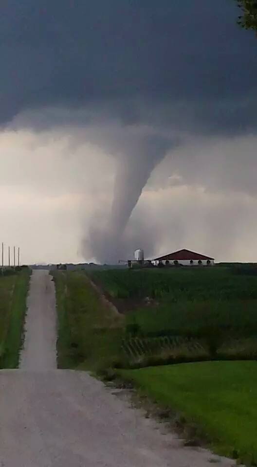
Photo via Iowa Storm Chaser Network’s Facebook page
At least one tornado touched down in rural southern Iowa last (Sunday) night, near the towns of Creston, Cromwell and Williamson. National Weather Service meteorologist Roger Vachalek can’t yet confirm whether there were multiple twisters.
“There may have been just one tornado,” Vachalek says. “We sent out a survey team today to take a look at that. That occurred in Adams County so we’ll have folks out there surveying the damage this morning and we’ll have some results from that later on this afternoon, probably before about 5 o’clock.”
While some crops were torn up and a few farmsteads were hit by the likely tornado, there are no reports of anyone being hurt. “From what we understand, from some of the photos we’ve received that will help us with the survey, it did damage some farms and cut through some fields, so there’s some significant damage,” Vachalek says. “Fortunately, we did not see it go through any major towns or cities last night.”
Before last night’s storms, there had only been 25 tornadoes reported statewide this year, far below the annual average of 46. Last year, there were 55 twisters reported across Iowa. Damage reports were scattered across central and southern Iowa from last night’s bout of severe weather.
“These thunderstorms that developed around the Des Moines metro area and then filled in quickly over the southern counties, did produce a number of large hail reports, some in excess of 1.75 inches, or golf ball-sized or larger,” Vachalek says.
Large hail was reported in the following counties: Adair, Dallas, Marion, Jasper, Taylor and Union. A possible microburst knocked over a semi-truck near Des Moines while Chariton reports winds of almost 60 miles an hour. Vachalek says we’ll see somewhat cooler weather most of this week, with rain possible much of the next five to seven days.
(Radio Iowa)


