
HARRISON-SHELBY-POTTAWATTAMIE COUNTIES: A HIGH WIND WARNING IN EFFECT FROM 5 PM TODAY UNTIL 3 AM THURSDAY. THE HIGH WIND WATCH IS NO LONGER IN EFFECT FOR THOSE COUNTIES.
AUDUBON-GUTHRIE-DALLAS-POLK-CASS-ADAIR-MADISON COUNTIES: HIGH WIND WARNING FROM 9-PM (WED.) THROUGH 6-AM THURSDAY. WIND ADVISORY FROM 6-AM-TO 6-PM THURSDAY.
SAC-CRAWFORD-CARROLL COUNTIES: HIGH WIND WARNING IN EFFECT UNTIL 6-AM THURSDAY, FOLLOWED BY A WIND ADVISORY FROM 6-AM THURSDAY UNTIL 6-P.M.
MILLS-MONTGOMERY-FREMONT AND PAGE COUNTIES: WIND ADVISORY 5-PM TODAY THROUGH 3-AM THURSDAY.
ADAMS-UNION-TAYLOR AND RINGGOLD COUNTIES: WIND ADVISORY IN EFFECT FROM 9-PM WED. (TODAY) UNTIL 6-AM THURSDAY.
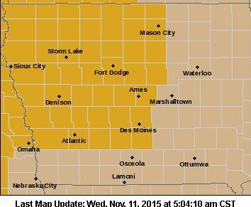
High Wind Warning for counties in gold, Wind Advisory for counties in brown
WINDS OF 35 TO 45 MPH WITH GUSTS OF 55 TO 60 MPH ARE LIKELY. WIND SPEEDS OF THIS MAGNITUDE WILL BE HAZARDOUS TO MOTORISTS, ESPECIALLY THOSE WITH HIGH PROFILE VEHICLES. CERTAIN OUTDOOR ITEMS WHICH CAN BE BLOWN AWAY SHOULD BE SECURED OR BROUGHT INDOORS.
A HIGH WIND WARNING MEANS A HAZARDOUS HIGH WIND EVENT IS EXPECTED OR OCCURRING. SUSTAINED WIND SPEEDS OF AT LEAST 40 MPH OR GUSTS OF 58 MPH OR MORE CAN LEAD TO PROPERTY DAMAGE.
NATIONAL WEATHER SERVICE DES MOINES IA
339 PM CST TUE NOV 10 2015

...VERY STRONG WINDS POSSIBLE WEDNESDAY NIGHT...

.A LARGE AND STRONG STORM SYSTEM WILL STRENGTHEN OVER THE REGION
WEDNESDAY...THEN MOVE QUICKLY AWAY FROM IOWA WEDNESDAY NIGHT. AS
THE STORM DEPARTS THE WINDS BEHIND IT WILL INCREASE SIGNIFICANTLY
WEDNESDAY NIGHT WITH HIGH WINDS EXPECTED OVERNIGHT. BRISK WINDS
ARE LIKELY AGAIN ON THURSDAY.

AUDUBON-GUTHRIE-CASS-ADAIR-
MADISON-ADAMS-UNION-CLARKE-TAYLOR-

...HIGH WIND WATCH REMAINS IN EFFECT FROM WEDNESDAY EVENING
THROUGH LATE WEDNESDAY NIGHT...
...WIND ADVISORY IN EFFECT FROM 6 AM TO 6 PM CST THURSDAY...

THE NATIONAL WEATHER SERVICE IN DES MOINES HAS ISSUED A WIND
ADVISORY...WHICH IS IN EFFECT FROM 6 AM TO 6 PM CST THURSDAY.

* TIMING...STRONGEST WINDS WILL REACH CENTRAL IOWA BY MIDNIGHT
  WEDNESDAY AND CONTINUE OVERNIGHT.

* WINDS...SUSTAINED SPEEDS NEARING 35 TO 40 MPH WITH GUSTS IN
  EXCESS OF 50 MPH LATE EVENING AND OVERNIGHT.

* IMPACTS...THE STRONG WINDS WILL AFFECT TRAVELERS...ESPECIALLY
  HIGH PROFILE VEHICLES ON NORTH SOUTH ROADS. LOOSE OBJECTS WILL
  ALSO BE BLOWN AROUND.

PRECAUTIONARY/PREPAREDNESS ACTIONS...

A HIGH WIND WATCH MEANS THERE IS THE POTENTIAL FOR A HAZARDOUS
HIGH WIND EVENT. SUSTAINED WINDS OF AT LEAST 40 MPH...OR GUSTS OF
58 MPH OR STRONGER MAY OCCUR. CONTINUE TO MONITOR THE LATEST
FORECASTS FOR A POSSIBLE UPDATE TO A HIGH WIND WARNING OR WIND
ADVISORY.

A WIND ADVISORY MEANS THAT WINDS OF 35 MPH ARE EXPECTED. WINDS
THIS STRONG CAN MAKE DRIVING DIFFICULT...ESPECIALLY FOR HIGH
PROFILE VEHICLES. USE EXTRA CAUTION.

CRAWFORD-CARROLL-GREENE

...HIGH WIND WARNING IN EFFECT FROM 9 PM WEDNESDAY TO 6 AM CST
THURSDAY...
...WIND ADVISORY IN EFFECT FROM 6 AM TO 6 PM CST THURSDAY...

THE NATIONAL WEATHER SERVICE IN DES MOINES HAS ISSUED A HIGH WIND
WARNING...WHICH IS IN EFFECT FROM 9 PM WEDNESDAY TO 6 AM CST
THURSDAY. A WIND ADVISORY HAS ALSO BEEN ISSUED. THIS WIND ADVISORY
IS IN EFFECT FROM 6 AM TO 6 PM CST THURSDAY. THE HIGH WIND WATCH
IS NO LONGER IN EFFECT.

* TIMING...STRONGEST WINDS WILL REACH WESTERN IOWA WEDNESDAY EVENING
  AND CONTINUE OVERNIGHT.

* WINDS...SUSTAINED SPEEDS OF 35 TO 40 MPH WITH GUSTS IN EXCESS OF
  55 MPH LATE EVENING AND OVERNIGHT.

* IMPACTS...THE STRONG WINDS WILL AFFECT TRAVELERS...ESPECIALLY
  HIGH PROFILE VEHICLES ON NORTH SOUTH ROADS. LOOSE OBJECTS WILL
  ALSO BE BLOWN AROUND.
HARRISON-SHELBY-POTTAWATTAMIE-MILLS-MONTGOMERY-FREMONT-PAGE-

...HIGH WIND WATCH NOW IN EFFECT FROM WEDNESDAY AFTERNOON THROUGH
LATE WEDNESDAY NIGHT...

* TIMING...6 PM WEDNESDAY THROUGH 6 AM THURSDAY

* WINDS...35 TO 45 MPH WITH GUSTS OF 55 TO 60 MPH.

* IMPACTS...WIND SPEEDS OF THIS MAGNITUDE WILL BE HAZARDOUS TO
  MOTORISTS...ESPECIALLY THOSE WITH HIGH PROFILE VEHICLES.
  CERTAIN OUTDOOR ITEMS WHICH CAN BE BLOWN AWAY SHOULD BE
  SECURED OR BROUGHT INDOORS. ALSO...THE POTENTIAL FOR REDUCED
  VISIBILITIES EXISTS DURING TIMES WHERE SNOWFALL MIXES WITH
  RAIN.
NORMAN, Okla. (AP) — Forecasters say a mixture of bad weather including heavy snow and tornadoes is expected as a strong storm system plows toward the central U.S. from the Rocky Mountains. A blizzard warning has been issued for Tuesday night and Wednesday in the Great Plains east of Denver, while tornadoes and high winds could rake parts of the Midwest on Wednesday.
Wet, heavy snow fell in Nevada on Tuesday morning, shuttering schools in Reno and knocking out power to thousands before moving eastward. Northeastern Colorado and western Kansas and Nebraska expect 6 inches of snow and wind gusts up to 60 mph overnight — a combination that can cause white-out conditions.
The Storm Prediction Center says an area from Nebraska to Illinois might face high winds, large hail and tornadoes Wednesday.
Today: Partly sunny. High near 62. S/SE @ 10-20.
Tonight: Mostly Cloudy w/areas of drizzle before midnight, then a slight chance of showers. Low around 50. New rainfall amounts of less than a tenth of an inch, except higher amounts possible in thunderstorms.
Veterans Day: Showers and thunderstorms. High near 61. S @ 15-25. New rainfall amounts between a half and three quarters of an inch possible.
Wednesday Night: (HIGH WIND WATCH) Cloudy, w/a 60% chance of showers through midnight. Gradually becoming partly cloudy, with a low around 36. W/NW @ 20-40mph w/gusts to near 50.
Thursday: P/Cldy. High near 50. W/NW @ 20-40mph.
Friday: P/Cldy & breezy. High near 47.
Monday’s High in Atlantic was 61. Our 24-hour ending today at 7-a.m., was 32.
Last Year on this date, the High in Atlantic was 61, and the Low was 18. The All-Time Record High in Atlantic on Nov. 10th was 76 in 1927. The Record Low was 3 in 1986.
Early This Morning: Mostly clear. Southeast wind near 5 mph.
Today: Partly sunny. High in the upper 50s. South wind 10 to 15 mph.
Tonight: Mostly cloudy. A slight chance of showers after midnight. A chance of thunderstorms early in the morning. Warmer. Low around 50. Southeast wind 5 to 10 mph. Chance of precipitation 50 percent.
Veterans Day: Breezy. Thunderstorms likely through mid morning… Then thunderstorms in the late morning and early afternoon. Thunderstorms likely late in the afternoon. High in the lower 60s. South wind 10 to 20 mph with gusts to around 30 mph. Chance of thunderstorms near 100 percent.
Wednesday Night: HIGH WIND WATCH in effect. Mostly cloudy. Light rain showers likely through midnight. Very windy. Colder. Low in the mid 30s. Northwest wind 25 to 35 mph with gusts to around 45 mph. Chance of showers 70 percent.
Thursday: Sunny…windy. High in the lower 50s. Northwest wind 20 to 30 mph.
Friday: Sunny. High in the upper 40s.
A HIGH WIND WATCH WILL BE IN EFFECT FROM WEDNESDAY EVENING THROUGH EARLY THURSDAY MORNING.
THE STRONGEST WINDS WILL REACH WESTERN IOWA AFTER SUNSET WEDNESDAY EVENING AND CENTRAL IOWA BY MIDNIGHT. SUSTAINED WIND SPEEDS OF 35 TO 40 MPH WITH GUSTS IN EXCESS OF 50, AND AS MUCH AS 60 MPH, CAN BE EXPECTED.
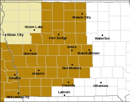
Counties shaded in brown are included in the High Wind Watch
THE STRONG WINDS WILL AFFECT TRAVELERS…ESPECIALLY HIGH PROFILE VEHICLES ON NORTH SOUTH ROADS. LOOSE OBJECTS WILL ALSO BE BLOWN AROUND.
PRECAUTIONARY/PREPAREDNESS ACTIONS…
A HIGH WIND WATCH MEANS THERE IS THE POTENTIAL FOR A HAZARDOUS HIGH WIND EVENT. SUSTAINED WINDS OF AT LEAST 40 MPH…OR GUSTS OF 58 MPH OR STRONGER MAY OCCUR. CONTINUE TO MONITOR THE LATEST FORECASTS.
There likely will -not- be snow, but forecasters say a large portion of Iowa could see severe weather roll into the state late Tuesday and into Wednesday. Roger Vachalek, a meteorologist at the National Weather Service, says it’s relatively rare but not unheard-of for a storm of this magnitude to strike during November. Vachalek says folks living across Iowa’s southern half should be on guard.
“There is a risk for severe weather in Iowa and especially for states to our south,” Vachalek says. “We have a slight risk all the way up to around Highway 30 and we may see storms that include hail or the possiblity of high winds and maybe some tornadoes.” Most of Iowa had very unseasonably warm weather last week, with highs in the 70s that were some 20 degrees warmer than normal. Vachalek says milder weather will be sticking around and should prevent any snowflakes from flying in this storm.
“There isn’t quite enough cold air coming in behind it to change the rain on the back side over to snow but we’ll be watching that,” Vachalek says. “There may be a brief change-over somewhere in far northwestern Iowa or maybe even in southern Minnesota, but for the most part, this will not be the snow event that some folks are looking for. We may have to wait a few weeks for that.” It’s a good idea, he says, for Iowans to be prepared for a storm like this.
“Folks should keep up with the forecast over the next few days and monitor the outlook that we mentioned for Wednesday and monitor the latest forecast and, of course, any watches and warnings that are issued,” Vachalek says. “We’re still a couple of days away from it so things could change, but it does look like a fairly significant event coming.” Learn more at the National Weather Service website: weather-dot-gov.
(Radio Iowa)
Today: Clear to partly cloudy. High around 62. S @ 10-15 mph.
Tonight: Clear to P/Cldy. Low around 35. South wind 5 to 10 mph.
Tuesday: P/Cldy. High near 62. S @ 10-20.
Tue. Night: Mostly cloudy w/a 40% chance of showers & thunderstorms after midnight. Low around 49. New rainfall amounts of less than a tenth of an inch, except higher amounts possible in thunderstorms.
Veterans Day: Showers and thunderstorms. High near 59. S/SE @ 10-20mph w/gusts to 25. New rainfall amounts between three quarters and one inch possible.
Wed. Night: Cloudy w/a 70% chance of shwrs. Low 35. New precipitation amounts between a tenth and quarter of an inch possible.
Thursday: P/Cldy, windy & cooler. High near 48.
Sunday’s High in Atlantic was 59. Our 24-hour Low ending today at 7-a.m., was 32. Last year on this date, the High in Atlantic was 56, and the Low 29. The All-Time Record High in Atlantic on Nov. 9th, was 73 in 1999. The Record Low was 8 in 1973.
Early This Morning: Clear. South wind 5 to 10 mph.
Today: Sunny. High around 60. South wind 5 to 15 mph.
Tonight: Mostly clear. Low in the upper 30s. South wind 5 to 10 mph.
Tuesday: Partly sunny. High in the upper 50s. South wind 10 to 15 mph.
Tuesday Night: Mostly cloudy. A 40 percent chance of thunderstorms after midnight. Not as cool. Low in the upper 40s. Southeast wind 5 to 10 mph.
Veterans Day: Thunderstorms. High in the upper 50s. Southeast wind 10 to 15 mph shifting to the southwest with gusts to around 30 mph in the afternoon. Chance of thunderstorms 90 percent.
Wednesday Night: Cloudy. Rain showers likely and isolated thunderstorms through midnight…then a chance of rain after midnight. Windy…colder. Low in the mid 30s. Chance of precipitation 70 percent.
Thursday: Mostly sunny. Breezy. High in the lower 50s.
331 AM CST SUN NOV 8 2015
EARLY THIS MORNING…CLEAR. SOUTH WIND NEAR 10 MPH.
TODAY…SUNNY…BREEZY. HIGH IN THE UPPER 50S. SOUTH WIND 10 TO 20 MPH.
TONIGHT…CLEAR. LOW IN THE MID 30S. SOUTH WIND 5 TO 10 MPH.
MONDAY…SUNNY. HIGH IN THE UPPER 50S. SOUTH WIND 10 TO 15 MPH WITH GUSTS TO AROUND 25 MPH.
TUESDAY…PARTLY SUNNY. HIGH AROUND 60. SOUTH WIND 10 TO 15 MPH.
TUESDAY NIGHT…CLOUDY. A SLIGHT CHANCE OF THUNDERSTORMS THROUGH MIDNIGHT…THEN A CHANCE OF THUNDERSTORMS AFTER MIDNIGHT. WARMER. LOW IN THE LOWER 50S. CHANCE OF THUNDERSTORMS 50 PERCENT.
VETERANS DAY…SHOWERS AND SCATTERED THUNDERSTORMS. HIGH IN THE UPPER 50S. CHANCE OF PRECIPITATION 80 PERCENT.


