Today: Partly cloudy. High 77. S @ 15-30.
Tonight: P/Cldy. Low 53. S @ 5-10.
Tomorrow: P/Cldy. High near 75. S @ 15-25.
Sunday-Monday: P/Cldy to Cldy w/scattered showers. High’s both days in the low 70’s.
Thursday’s High in Atlantic was 73. The 24-hour Low thru 7-a.m. today was 47. Last year on this date, our High in Atlantic was 61 and the low was 45. The All-time Record High in Atlantic on this date was 84 in 1920. The Record Low was 17 in 1926 & 1962.
346 AM CDT FRI APR 15 2016
EARLY THIS MORNING…CLEAR. SOUTHEAST WIND AROUND 10 MPH.
TODAY…SUNNY…BREEZY. HIGH IN THE MID 70S. SOUTH WIND 10 TO 15 MPH INCREASING TO AROUND 20 MPH IN THE AFTERNOON. GUSTS UP TO 30 MPH.
TONIGHT…PARTLY CLOUDY THROUGH MIDNIGHT THEN BECOMING MOSTLY CLOUDY. BREEZY. LOW IN THE MID 50S. SOUTHEAST WIND 10 TO 20 MPH.
SATURDAY…PARTLY SUNNY. BREEZY. HIGH IN THE LOWER 70S. SOUTHEAST WIND 10 TO 20 MPH.
SATURDAY NIGHT…MOSTLY CLOUDY. LOW IN THE MID 50S. SOUTHEAST WIND 5 TO 15 MPH. GUSTS UP TO 25 MPH THROUGH MIDNIGHT.
SUNDAY…PARTLY SUNNY. HIGH IN THE MID 70S. SOUTHEAST WIND 5 TO 15 MPH.
SUNDAY NIGHT…MOSTLY CLOUDY WITH A 20 PERCENT CHANCE OF SHOWERS. LOW IN THE MID 50S.
MONDAY…CLOUDY WITH A CHANCE OF SHOWERS AND ISOLATED THUNDERSTORMS. HIGH IN THE UPPER 60S. CHANCE OF PRECIPITATION 50 PERCENT.
Today: Mostly Sunny. High 77. S @ 15-25.
Tonight: Fair to P/Cldy. Low 50. S @ 5-10.
Tomorrow: Mo. Sunny. High near 77. S @ 10-20.
Saturday: P/Cldy. High 75.
Sunday: P/Cldy w/a chance of scattered showers. High 72.
Wednesday’s High in Atlantic was 73. The 24-hour Low thru 7-a.m. today was 42. Last year on this date, our High in Atlantic was 68 and the low was 33. The All-time Record High in Atlantic on this date was 89 in 2003. The Record Low was 11 in 1907.
346 AM CDT THU APR 14 2016
EARLY THIS MORNING…PARTLY CLOUDY. SOUTH WIND 5 TO 10 MPH.
TODAY…SUNNY…BREEZY. HIGH IN THE LOWER 70S. SOUTH WIND 10 TO 20 MPH.
TONIGHT…CLEAR. LOW IN THE LOWER 50S. SOUTHEAST WIND 10 TO 15 MPH.
FRIDAY…SUNNY…BREEZY. HIGH IN THE MID 70S. SOUTHEAST WIND 10 TO 15 MPH INCREASING TO SOUTH 20 TO 25 MPH IN THE AFTERNOON.
SATURDAY…PARTLY SUNNY. HIGH IN THE LOWER 70S. SOUTH WIND 10 TO 15 MPH WITH GUSTS TO AROUND 25 MPH.
SUNDAY…MOSTLY CLOUDY WITH A 20 PERCENT CHANCE OF SHOWERS. HIGH IN THE LOWER 70S.
Today: Partly Cloudy. High 72. S @ 15-25.
Tonight: Fair to P/Cldy. Low 47. S @ 5-10.
Tomorrow: Mo. Sunny. High near 74. S @ 10-20.
Friday: P/Cldy. High 74.
Saturday: P/Cldy. High 76.
Tuesday’s High in Atlantic was 62. The 24-hour Low thru 7-a.m. today was 19. Last year on this date, our High in Atlantic was 66 and the low was 31. The All-time Record High in Atlantic on this date was 86 in 2006. The Record Low was 11 in 1950.
EARLY THIS MORNING…MOSTLY CLEAR. NOT AS COOL. SOUTH WIND 10 TO 15 MPH.
TODAY…SUNNY…BREEZY. HIGH IN THE LOWER 70S. SOUTH WIND 10 TO 20 MPH.
TONIGHT…MOSTLY CLEAR. LOW IN THE MID 40S. SOUTH WIND 10 TO 15 MPH.
THURSDAY…SUNNY…BREEZY. HIGH IN THE LOWER 70S. SOUTH WIND 5 TO 15 MPH INCREASING TO 15 TO 20 MPH IN THE AFTERNOON. GUSTS UP TO 30 MPH.
FRIDAY…SUNNY…BREEZY. HIGH IN THE LOWER 70S. SOUTHEAST WIND 10 TO 15 MPH INCREASING TO AROUND 20 MPH IN THE AFTERNOON. GUSTS UP TO 30 MPH.
SATURDAY…PARTLY SUNNY. HIGH IN THE LOWER 70S.
**Freeze Warning until 9-a.m.**
Today: Partly Cloudy. High 58. S @ 5-10.
Tonight: P/Cldy. Low 36. S @ 5-10.
Tomorrow: P/Cldy. High near 70. S @ 10-20.
Thursday: P/Cldy. High 72.
Friay: P/Cldy. High 72.
Monday’s High in Atlantic was 52. The Low thru 7-a.m. today was 18. Last year on this date, our High in Atlantic was 73 and the low was 36. The All-time Record High in Atlantic on this date was 86 in 1916. The Record Low was 13 in 1957.
346 AM CDT TUE APR 12 2016
…FREEZE WARNING IN EFFECT UNTIL 9 AM CDT THIS MORNING…
EARLY THIS MORNING…CLEAR. NORTHEAST WIND NEAR 5 MPH.
TODAY…SUNNY. HIGH IN THE UPPER 50S. SOUTH WIND 5 TO 15 MPH.
TONIGHT…MOSTLY CLEAR. NOT AS COOL. LOW IN THE UPPER 30S. SOUTH WIND 10 TO 15 MPH.
WEDNESDAY…SUNNY. HIGH IN THE UPPER 60S. SOUTH WIND 5 TO 15 MPH WITH GUSTS TO AROUND 25 MPH.
THURSDAY…SUNNY…BREEZY. HIGH AROUND 70. SOUTHEAST WIND 5 TO 15 MPH INCREASING TO 15 TO 20 MPH IN THE AFTERNOON. GUSTS UP TO 30 MPH.
FRIDAY…MOSTLY SUNNY. BREEZY. HIGH IN THE LOWER 70S.
CRAWFORD-CARROLL-AUDUBON-GUTHRIE-DALLAS-
CASS-ADAIR-MADISON-ADAMS-UNION-TAYLOR-RINGGOLD MONONA-HARRISON-SHELBY-POTTAWATTAMIE-MILLS-MONTGOMERY-FREMONT-PAGE-COUNTIES….942 AM CDT MON APR 11 2016 (updated 10-a.m.)
…FREEZE WARNING IN EFFECT FROM 1 AM TO 9 AM CDT TUESDAY…
THE NATIONAL WEATHER SERVICE IN DES MOINES HAS ISSUED A FREEZE
WARNING…WHICH IS IN EFFECT FROM 1 AM TO 9 AM CDT TUESDAY.
* TEMPERATURE…TEMPERATURES WILL FALL BELOW 32 DEGREES AFTER
MIDNIGHT REACHING OVERNIGHT LOWS IN THE MIDDLE TO UPPER 20S.
* IMPACTS…TENDER UNPROTECTED VEGETATION MAY BE KILLED OR DAMAGED BY THE COLD TEMPERATURES AND RESULTANT FREEZE.
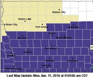
Freeze Warning for counties in purple
PRECAUTIONARY/PREPAREDNESS ACTIONS…
A FREEZE WARNING MEANS SUB-FREEZING TEMPERATURES ARE IMMINENT OR HIGHLY LIKELY. THESE CONDITIONS WILL KILL CROPS AND OTHER SENSITIVE VEGETATION.
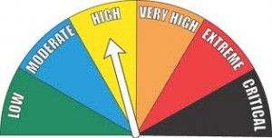
Emergency Management officials in Shelby County say the field/grassland Fire Danger rating will remain “High,” this week. EMA Operations Officer Jason Wickizer says drying conditions, wind and abundant sunshine along with low humidity will make for dangerous fire conditions.
Anyone who plans to conduct controlled burns should contact their local fire chief, first. Be sure and call 755-2124 also, with the location of your burn, so dispatchers can gather logistical data. Burns should be conducted with fire chief approval during the late evening or early morning hours only, when winds are usually reduced.