
507 AM CDT SUN JUN 12 2016
EARLY THIS MORNING…MOSTLY CLEAR. SOUTH WIND NEAR 5 MPH.
TODAY…SUNNY. HIGH IN THE LOWER 90S. SOUTH WIND 5 TO 15 MPH.
TONIGHT…PARTLY CLOUDY. A 20 PERCENT CHANCE OF THUNDERSTORMS EARLY IN THE MORNING. LOW IN THE LOWER 70S. SOUTH WIND 5 TO 10 MPH.
MONDAY…MOSTLY SUNNY IN THE MORNING THEN BECOMING MOSTLY CLOUDY. A 50 PERCENT CHANCE OF THUNDERSTORMS. HIGH IN THE UPPER 80S. SOUTHWEST WIND 5 TO 10 MPH.
MONDAY NIGHT…MOSTLY CLOUDY WITH A 50 PERCENT CHANCE OF THUNDERSTORMS. LOW IN THE UPPER 60S. EAST WIND AROUND 5 MPH.
TUESDAY…THUNDERSTORMS LIKELY. HIGH IN THE MID 80S. SOUTHEAST WIND 5 TO 15 MPH. GUSTS UP TO 25 MPH IN THE AFTERNOON. CHANCE OF THUNDERSTORMS 70 PERCENT.
TUESDAY NIGHT…THUNDERSTORMS LIKELY. LOW IN THE UPPER 60S. CHANCE OF THUNDERSTORMS 70 PERCENT.
WEDNESDAY…MOSTLY SUNNY. HIGH IN THE UPPER 80S.
DES MOINES, Iowa (AP) — It looks to be a miserably hot weekend in parts of Iowa and Nebraska this weekend. The National Weather Service has issued a heat advisory for Des Moines and central and northern parts of Nebraska and Iowa.
The service says temperature in the mid to upper 90s, combined with high humidity, will send heat index values into the triple digits in Nebraska on Saturday. The heat advisory will remain in effect for Des Moines and other parts of Iowa through Sunday evening.
The service cautions people in the advisory areas to drink plenty of fluids, stay out of the sun and stay in an air-conditioned room, if possible.
SPENCER, Iowa (AP) — Residents in northwest Iowa are cleaning up this weekend after a series of strong thunderstorms knocked down tree limbs and caused power outages Friday night. The Sioux City Journal reports Sioux, Osceola, Dickinson, O’Brien, Cherokee and Clay counties are among the areas hit by high wind gusts and large hail.
The sheriff’s offices in Dickinson and Osceola counties reported down tree limbs and power outages. Alex Ferguson with the National Weather Service in Sioux Falls says wind gusts sometimes exceeding 60 mph were recorded in several counties. The highest, at 67 mph, was recorded at 9:14 p.m. at the Spencer Airport.
Ferguson says golf-ball-sized hail was reported around 8 p.m. in Dickinson County.
Today: Sunny, with a high near 96. Heat index values as high as 101. South southwest wind 8 to 11 mph.
Tonight: Mostly clear, with a low around 71. South wind 7 to 10 mph.
Sunday: Sunny, with a high near 94. South wind 7 to 14 mph, with gusts as high as 18 mph.
Sunday Night: A 20 percent chance of showers and thunderstorms after 1am. Mostly clear, with a low around 71. South wind 5 to 10 mph.
Monday: A 50 percent chance of showers and thunderstorms. Partly sunny, with a high near 88. Southwest wind around 6 mph. New rainfall amounts between a tenth and quarter of an inch, except higher amounts possible in thunderstorms.
Monday Night: A 40 percent chance of showers and thunderstorms. Mostly cloudy, with a low around 69. New rainfall amounts of less than a tenth of an inch, except higher amounts possible in thunderstorms.
Tuesday: Showers and thunderstorms likely. Mostly cloudy, with a high near 85. Chance of precipitation is 60%.
Friday’s High in Atlantic was 94. Our Low this morning was 73. Last year on this date, our High in Atlantic was 68 and the low was 60. The All-time Record High in Atlantic on this date was 99 in 1892. The Record Low was 36 in 1903.
The National Weather Service has placed more than a dozen counties in northwest and central Iowa under a heat advisory through Sunday. Temperatures are expected to reach the upper 90s, while heat indices could climb into the triple digits in Sioux City, Spencer, Des Moines, Ames, and surrounding cities. Staci Schweder, a nurse with Mercy Medical in Sioux City, says anyone spending time outdoors should drink plenty of water.
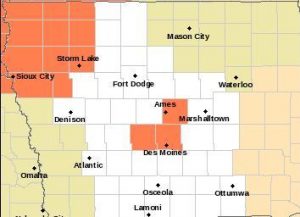
Heat Advisory (counties in Orange) until 9-p.m. Saturday for n.w. IA, & until 7-p.m. Sunday for parts of central IA
“Be proactive with that. Start drinking (water) right away in the morning and continue to drink throughout the day,” Schweder says. While staying hydrated is key to avoiding heat exhaustion, Schweder suggests wearing light, loose-fitting clothing and taking plenty of breaks from the sun as well. She also recommends using wet washcloths or towels on the neck or forearms to keep cool. The warning signs of heat stroke include feeling faint or nauseated.
“Heart racing…cool, clammy skin…if those start to happen, you definitely want to find shade and get to a cooler environment,” Schweder says. Some relief from the heat may arrive over northeast Iowa Sunday. The forecast calls for the possibility of some thunderstorms over northern Iowa tonight (Friday) and over northern and central Iowa Saturday. The National Weather Service reports wetter and cooler conditions are expected early next week.
(Radio Iowa)
Today: Partly-to-Mostly Sunny, breezy & humid. High 95. Heat Index near 100. SW @ 15-25.
Tonight: P/Cldy. Low 73. S @ 10-15.
Tomorrow: P/Cldy. High 95. Heat Index near 102. SW @ 10-20.
Tom. Night: Mo. Clear. Low 72.
Sunday: P/Cldy. High 93. S @ 5-10.
Sunday Night: A slight chance of shwrs & tstrms. Low 73.
Monday: P/Cldy to Cldy w/a 50% chance of shwrs & tstrms. High 88.
Thursday’s High in Atlantic was 93. Our 24-hour Low thru 7-a.m. today was 72. Last year on this date, our High in Atlantic was 88 and the low was 62. The All-time Record High in Atlantic on this date was 104 in 1933. The Record Low was 40 in 1966.
A forum next week will focus on the intersection between faith, climate change and agriculture. Reverend Susan Guy, executive director of Iowa Interfaith Power & Light, says the panelists will talk about how climate change is altering the face of farming, why the issue is important to them and how their faith calls them to respond. “We know that there are a lot of people in rural communities who are very dependent on agriculture to make a living,” Reverend Guy says. “We know that extreme weather events are really having an impact on them. We feel this is part of our mission to reach out to those who are most vulnerable to the impacts of climate change.”
Members of the panel include Fred Kirschenmann, a farmer and former director of the Leopold Center at Iowa State University and Chris Anderson, assistant director of the I-S-U’s Climate Science Program. “Farmers are doing a lot of great things and they’re aware of the impacts of climate change in terms of their planting seasons and extreme weather events,” Guy says. “We want to normalize the conversation about climate change and agriculture and talk about how farmers and rural communities are adapting and mitigating and helping to find solutions.”
Those solutions include using more renewable fuels and working to make farming operations more energy efficient, in addition to locating wind turbines on their properties to help offset costs. Still, Guy says, climate change continues to present significant challenges to growers. “We’re having extreme weather events and a lot of flooding, so it’s keeping farmers out of their fields or it’s destroying crops that are already in the ground,” Guy says. “We’ve had seasons where we’ve had both flooding and drought in the same year, so we’re going from lots and lots of water to no water which is also having a negative impact on crops.”
The forum is open to anyone and will start at 6:30 PM Wednesday (June 15) at the Christy 4-H Hall in Nevada. Guy says Iowa Interfaith Power & Light is a non-profit group dedicated to inspiring and equipping people of faith to become leaders finding solutions to climate change.
(Radio Iowa)
Early This Morning: Mostly clear. South wind 5 to 15 mph.
Today: Sunny…hot. High in the mid 90s. South wind 10 to 15 mph with gusts to around 25 mph. Highest heat index readings around 100 in the afternoon.
Tonight: Mostly clear. Low in the lower 70s. South wind 5 to 15 mph. Gusts up to 25 mph through midnight.
Saturday: Sunny…hot. High in the mid 90s. Southwest wind 5 to 10 mph. Highest heat index readings 100 to 102 in the afternoon.
Saturday Night: Mostly clear. Low in the lower 70s. South wind 5 to 10 mph. Highest heat index readings 100 to 102 through midnight.
Sunday: Sunny. High in the mid 90s. South wind 5 to 15 mph. Highest heat index readings around 100 in the afternoon.
Sunday Night: Partly cloudy with a 30 percent chance of thunderstorms. Low in the lower 70s.
Monday: Mostly cloudy with a 50 percent chance of thunderstorms. High in the upper 80s.
Despite the wet spring across much of the Midwest, there’s still the potential for drought. Doug Kluck, a climatologist with NOAA in Kansas City, says most of the Missouri River Basin is far from drought, though some potential dry spots are starting to emerge in the upper basin. Kluck says western Iowa shouldn’t have anything to worry about, at least not yet.
“It’s not surprising this time of year, droughts can happen really fast,” Kluck says. “Sometimes, they call them flash droughts, if it gets really hot and winds pick up. Those are usually agriculturally-based impacts.” Kluck says the El Nino effect on the weather has passed now with a La Nina pattern likely, meaning, it will be hotter and wetter than normal over much of the region in the months to come.
“As far as predictions, right now we’re slipping into what we call a Neutral Tropical Pacific with La Nina likely developing a little later this summer,” Kluck says. “Really, the impacts from that La Nina tend not to be felt until late fall.” Barges should be running all summer on the Missouri, according to U-S Army Corps of Engineers hydraulic engineer Joel Knofcynski. He says the upper Missouri River reservoirs -do- have enough capacity to handle the heavy rainfall this spring and the current heavy snow melt.
“The service level for the remainder of the navigation season and the navigation season length are based on the July 1st system storage check,” Knofcynski says. “Under all three simulations, flow support for navigaton would be full service and a full eight-month navigation season would be provided.” Water levels are high on the upper Missouri River reservoirs, but enough capacity remains to reduce flooding while maintaining barge traffic. He notes, there could be some minor-to-moderate flooding along the Missouri River, but nothing that poses a serious threat to property.
(Radio Iowa)
Forecasters say a heat wave will wash over Iowa today (Thursday) that will likely last through the weekend, with steamy high temperatures in the 90s — and the heat may doom many pets. Josh Colvin, with the Animal Rescue League of Iowa, expects they’ll average five calls a day alerting them to animals that are locked inside hot cars.
“If we get a call like that, first, we’re going to try to identify how critical it is,” Colvin says. “If it’s very critical, we’re going to call the police department over and make entry into the vehicle. We’re going to try to identify where the owner is, who the owner is, if we’ve got a little bit of time but it’s a hurry up and make a decision on whether we’re going to gain entry in that vehicle.” Sad but true, he says, hundreds of cats and dogs die needlessly every summer by being left inside cars.
“People are on the fence, ‘Well, I don’t want to call on my neighbor,’ because they just don’t want to do that,” Colvin says, “but if they’re really concerned that the animal is in danger, we really encourage people to call us.” Colvin says the situation can rapidly become lethal. “If we’re talking about animals in vehicles, with weather like today, tomorrow and this weekend, it can become critical very quickly, in a matter of minutes to be frank,” Colvin says. “We’ve really got to respond to those calls quickly.”
Pets should never be left unattended in a car when the temperature is more than 70 degrees, even for a few minutes. When it’s 80 degrees, the temperature inside a car can reach 99 degrees or hotter within ten minutes, and leaving windows cracked does very little to lower the temp. Colvin reminds people to act immediately if they see a distressed animal in an unattended car. Call your local law enforcement agency.
(Radio Iowa)


