
Today: Thunderstorms. High in the lower 80s. Southwest wind 5 to 10 mph. Chance of thunderstorms 80 percent.
Tonight: Mostly cloudy with thunderstorms likely in the evening…then mostly cloudy with a chance of thunderstorms before midnight and early morning. Partly cloudy early in the morning. Low in the lower 60s. South wind 5 to 10 mph shifting to the west after midnight. Chance of thunderstorms 60 percent.
Thursday: Mostly sunny. High in the lower 80s. North wind around 5 mph shifting to the northeast in the afternoon.
Thursday Night: Mostly cloudy with a 50 percent chance of thunderstorms. Low in the mid 60s. Southeast wind near 5 mph.
Friday: Thunderstorms likely. High in the upper 70s. Chance of thunderstorms 70 percent.
Friday Night: Mostly cloudy with a 40 percent chance of thunderstorms. Cooler. Low in the mid 50s.
Saturday: Sunny. High in the lower 70s.
Today: Partly Cloudy, warm & humid. Isolate shwrs & tstrms late. High 90. SW @ 15-25.
Tonight: Cldy w/scattered shwrs & tstrms. Low 74. S @10.
Tomorrow: Cldy w/scatt shwrs & tstrms. High 80. S-NW @ 10-15.
Thursday: P/Cldy. High 82.
Friday: Scattered shwrs & tstrms. High near 80.
Monday’s High in Atlantic was 89.Our 24-hour Low was 69. Last year on this date, our High in Atlantic was 92 and the low was 71. The Record High in Atlantic on this date was 103 in 1939. The Record Low was 36 in 1962.
Early This Morning: Mostly clear. South wind 5 to 15 mph.
Today: Mostly sunny. Hot and humid. Breezy. High in the upper 80s. South wind 10 to 20 mph with gusts to around 30 mph. Highest heat index readings around 100 in the afternoon.
Tonight: Mostly cloudy. A chance of thunderstorms until early morning…then thunderstorms likely early in the morning. Low in the lower 70s. South wind 5 to 15 mph. Gusts up to 25 mph through midnight. Chance of thunderstorms 70 percent.
Wednesday: Thunderstorms. High in the lower 80s. South wind 5 to 15 mph. Chance of thunderstorms 80 percent.
Wednesday Night: Mostly cloudy with a 40 percent chance of thunderstorms through midnight…then partly cloudy after midnight. Low in the mid 60s. Southwest wind 5 to 10 mph.
Thursday: Mostly sunny. High in the lower 80s. North wind around 5 mph shifting to the east in the afternoon.
Friday: Mostly cloudy with a 50 percent chance of thunderstorms. High in the upper 70s.
Today: Partly Cloudy, warm & humid. High 90. SW @ 10-20. Tonight: P/Cldy w/isolated shwrs & tstrms. Low 73. S @10.
Tomorrow: P/Cldy, warm & humid w/scatt shwrs & tstrms. High 87. S @ 10-20.
Wednesday: Cldy wscattered showers & tstrms. High 83.
Thursday: Cldy w/scattered shwrs & tstrms. High 80.
Sunday’s High in Atlantic was 79. We received .05” of an inch of rain yesterday. Our 24-hour Low was 64. Last year on this date, our High in Atlantic was 90 and the low was 72. The Record High in Atlantic on this date was 104 in 1913. The Record Low was 34 in 1962.
Early This Morning: Mostly cloudy. South wind 10 to 15 mph.
Today: Mostly sunny. Breezy. High in the upper 80s. South wind 10 to 20 mph with gusts to around 30 mph.
Tonight: Partly cloudy. Breezy. Low in the lower 70s. South wind 10 to 20 mph. Gusts up to 30 mph through midnight.
Tuesday: Mostly sunny with a 40 percent chance of thunderstorms. Breezy. High around 90. South wind 10 to 20 mph with gusts to around 30 mph.
Tuesday Night: Mostly cloudy with thunderstorms likely. Low in the upper 60s. South wind 10 to 15 mph. Gusts up to 25 mph through midnight. Chance of thunderstorms 60 percent.
Wednesday: Mostly cloudy. A chance of thunderstorms in the morning…then thunderstorms likely in the afternoon. High in the lower 80s. South wind 10 to 15 mph. Chance of thunderstorms 70 percent.
Thursday: Mostly sunny. High in the lower 80s.
Today: Partly Sunny w/a 20% chance of showers and thunderstorms between noon and 3pm. High near 81. S/SE winds at 5-15mph gusting to around 25.
Tonight: Partly Cloudy to Cloudy w/a 30% chance of showers and thunderstorms, mainly between 3am and 5am. Low around 67. S/SE @ 15-25.
Labor Day: Mostly sunny & breezy, with a high near 88. S @ 15-30mph.
Monday Night: P/Cldy w/a 20% chance of showers and thunderstorms after 1am. Low around 71. S @ 15-25.
Tuesday: P/Sunny & breezy, w/a 40% chance of showers and thunderstorms. High near 89. S @ 10-25mph.
Tuesday Night: Showers and thunderstorms likely. Low around 69. New rainfall amounts between a quarter and half of an inch possible.
Wednesday: Showers and thunderstorms likely. High near 86.
(Update 8:32-a.m. Aftershock felt just before 8-a.m. 9.3 miles NW of Pawnee, OK, 3.6 magnitude, about 1.1 miles deep)
CHICAGO (AP) – An earthquake has rattled a swath of the Great Plains, from Iowa and Nebraska to as far south as northern Texas. The temblor shockwave was felt in Atlantic, Brayton, Des Moines and Omaha at around 7:05-a.m.. KJAN received several phone calls from residents saying their lights were swaying and they felt a rumble. The United States Geological Survey (USGS) said the quake happened at 7:02-a.m., and measured 5.6 on the Richter Scale and was centered about 8.5-miles northwest of Pawnee, Oklahoma. It occurred at a depth of about 4-miles, or very shallow by most standards. It also tweeted that aftershocks may occur. (One aftershock felt just before 8-a.m. 9.3 miles NW of Pawnee, OK, 3.6 magnitude, about 1.1 miles deep)
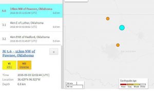
The light blue dot on the map is the epicenter of the initial quake that happened at 7:02-a.m. CDT 9/3/16
Sean Weide in Omaha, Nebraska, said he’d never been in an earthquake before and thought he was getting dizzy. Weide said he and one of his daughters “heard the building start creaking” and said it “was surreal.” People in Kansas City, Missouri; Fayetteville, Arkansas; and Norman, Oklahoma, all reported feeling the earthquake. Dallas TV station WFAA tweeted that it felt the quake, too.
Today: Mostly sunny, with a high near 77. South wind 6 to 13 mph, with gusts as high as 18 mph.
Tonight: Partly cloudy, with a low around 61. South southeast wind 7 to 10 mph.
Sunday: Partly sunny, with a high near 82. Breezy, with a south southeast wind 9 to 18 mph, with gusts as high as 26 mph.
Sunday Night: A 20 percent chance of showers and thunderstorms. Mostly cloudy, with a low around 68. Breezy, with a south southeast wind 14 to 16 mph, with gusts as high as 23 mph.
Labor Day: Mostly sunny, with a high near 87. Windy, with a south wind 14 to 21 mph, with gusts as high as 29 mph.
Monday Night: A 20 percent chance of showers and thunderstorms. Partly cloudy, with a low around 72. Breezy.
Tuesday: A 40 percent chance of showers and thunderstorms. Partly sunny, with a high near 88.
More than 80 percent of the state’s corn and soybean fields were rated in “good” or “excellent” condition at the start of this week and one weather experts says the 2016 growing season “has turned out pretty well” for Iowa farmers. State Climatologist Harry Hillaker says crop development is about a week to a week-and-a-half ahead of normal. “Things for the most part got planted on a timely basis, with exceptions in far western Iowa that had a pretty mid-April and early May, but otherwise in much of the state things got planted on time. It’s been a relatively warm growing season, so things that did get planted on time have been progressing along very well.”
Yield prospects are “looking quite good” for most of the state, according to Hillaker. “A few places still a bit on the dry side, but nothing really super dry at this point,” Hillaker says. “Certainly northwest Iowa could use some rain, although it’s getting late enough in the growing season that it may still, perhaps, help out the soybean, but probably too late to have any benefit for the corn crop in that part of the state.”
A small area stretching from Onawa to just northwest of Sac City got NO rainfall at all last week, while nearly nine inches fell near Decorah. About nine-tenths of an inch is the normal amount of rainfall in Iowa for the final week of August.
(Radio Iowa)
Today: Areas of fog this morning; Mo. Sunny. High 78. NE @ 10-15.
Tonight: Mo. Clear. Low around 55.
Tomorrow: Partly Cloudy. High near 80 SE @ 10-15.
Sunday: P/Cldy w/isolated showers possible. High 83.
Monday: P/Cldy w/isolated shwrs & tstrms. High 87.
Thursday’s High in Atlantic was 80. Our 24-hour Low was 52. Last year on this date, our High in Atlantic was 86 and the low was 70. The Record High in Atlantic on this date was 101 in 2000. The Record Low was 30 in 1983.


