
(Updated 7-a.m. to expand time frame for western/s.w. IA)
A DENSE FOG ADVISORY REMAINS IN EFFECT UNTIL 11 AM TODAY (SUNDAY) FOR HARRISON-SHELBY-POTTAWATTAMIE-MILLS-MONTGOMERY-FREMONT AND PAGE COUNTIES, AND UNTIL 9-A.M. FOR CASS AND OTHER AREA COUNTIES.
* VISIBILITY…AVERAGING ONE QUARTER MILE OR LESS THROUGH MID MORNING.
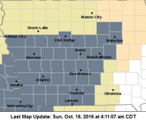
Dense Fog Advisory for counties in gray.
* IMPACTS…THE REDUCED VISIBILITIES WILL MAKE FOR HAZARDOUS DRIVING CONDITIONS IF CAUTION IS NOT TAKEN. TRAVEL IS LIKELY TO BE CHALLENGING AT TIMES THROUGHOUT THE KJAN LISTENING AREA.
PRECAUTIONARY/PREPAREDNESS ACTIONS…
A DENSE FOG ADVISORY MEANS VISIBILITIES WILL FREQUENTLY BE REDUCED TO LESS THAN ONE QUARTER MILE. IF DRIVING… SLOW DOWN… USE YOUR HEADLIGHTS… AND LEAVE PLENTY OF DISTANCE AHEAD OF YOU.
AREA COUNTIES: CRAWFORD-CARROLL-AUDUBON-GUTHRIE-DALLAS-CASS-ADAIR-MADISON-ADAMS-UNION-TAYLOR-RINGGOLD:
THE NATIONAL WEATHER SERVICE IN DES MOINES HAS ISSUED A DENSE FOG ADVISORY EFFECTIVE FROM 2-A.M. UNTIL TIL 8-A.M. SUNDAY.
HARRISON-SHELBY-POTTAWATTAMIE-MILLS-MONTGOMERY-FREMONT-PAGE COUNTIES:
DENSE FOG ADVISORY IN EFFECT FROM 2 AM TO 9 AM CDT SUNDAY.
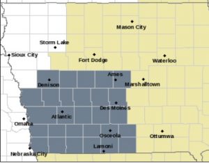
Dense Fog Advisory Sunday morning for counties in gray.
* VISIBILITY…VISIBILITY OF ONE QUARTER MILE OR LESS CAN BE EXPECTED…ESPECIALLY BETWEEN 4 AND 7 AM EARLY SUNDAY MORNING.
* IMPACTS…TRAVEL MAY BE DIFFICULT AND MUCH SLOWER DUE TO VERY LOW VISIBILITIES. ALLOW EXTRA TIME TO REACH YOUR DESTINATION SAFELY. FOLLOW FOG SAFETY RULES AND USE LOW BEAM HEADLIGHTS.
CHECK THE LATEST VISIBILITY PRIOR TO HEADING OUT OVERNIGHT AND EARLY SUNDAY MORNING.
PRECAUTIONARY/PREPAREDNESS ACTIONS...
A DENSE FOG ADVISORY MEANS VISIBILITIES WILL FREQUENTLY BE REDUCED TO LESS THAN ONE QUARTER MILE. IF DRIVING…SLOW DOWN… USE YOUR HEADLIGHTS…AND LEAVE PLENTY OF DISTANCE AHEAD OF YOU.
Today: Areas of fog this morning; P/Sunny. High 72. S/SW @ 10-20.
Tonight: Mo. Cldy w/a chance of showers. Low 64. S @ 5-10.
Tomorrow: A chance of morning showers; P/Sunny. High 78. E/SE @ 10-15.
Tom. Night: Mo. Cldy. Low 68.
Monday: P/Sunny. High 82.
Tuesday: Mo. Sunny. High 71.
Wednesday: P/Sunny. High 60.
Friday’s High in Atlantic was 62. The temps rose overnight into early Saturday morning, giving us a recorded 24-hour High of 66. We also received a Trace of precipitation, Friday. Our 24-hour Low (ending at 7-a.m. today) was 48. Last year on this date, our High in Atlantic was 70 and the low was 30. The Record High in Atlantic on this date was 89 in 1892. The Record Low was 17 in 1952.
Early This Morning: Cloudy…breezy…warmer. Patchy fog. Patchy drizzle. South wind 15 to 20 mph.
Today: Cloudy. Patchy fog through mid morning. Patchy drizzle until late afternoon…then a slight chance of light rain and isolated thunderstorms late in the afternoon. Breezy. High in the lower 70s. South wind 15 to 20 mph. Chance of precipitation 20 percent.
Tonight: Mostly cloudy. A slight chance of light rain and isolated thunderstorms in the evening. Areas of fog after midnight. Low in the upper 50s. South wind near 10 mph. Chance of precipitation 20 percent.
Sunday: Partly sunny. Areas of fog through mid morning. High in the lower 80s. Southeast wind near 10 mph shifting to the south with gusts to around 25 mph in the afternoon.
Monday: Partly sunny in the morning then clearing. Breezy. High in the lower 80s. Southwest wind 10 to 20 mph with gusts to around 30 mph.
Tuesday: Sunny…cooler. High in the lower 70s.
Today: Mostly cloudy, with a high near 67. Breezy, with a south wind 7 to 12 mph increasing to 13 to 18 mph in the afternoon. Winds could gust as high as 25 mph.
Tonight: Patchy drizzle after 1am. Mostly cloudy, with a low around 60. Breezy, with a south wind 13 to 16 mph, with gusts as high as 29 mph.
Saturday: Patchy drizzle before 1pm. Cloudy, with a high near 73. Breezy, with a south southwest wind around 16 mph, with gusts as high as 28 mph.
Saturday Night: Mostly cloudy, with a low around 58. South southwest wind 5 to 7 mph becoming calm in the evening.
Sunday: Partly sunny, with a high near 80. South southeast wind 5 to 14 mph, with gusts as high as 24 mph.
Sunday Night: Partly cloudy, with a low around 60.
Monday: Mostly sunny, with a high near 82. Breezy.
Thursday’s High in Atlantic was 60. Our 24-hour Low today (ending at 7-a.m.) will be 27. Last year on this date, our High in Atlantic was 72 and the low was 37. The Record High in Atlantic on this date was 88 in 1897. The Record Low was 16 in 1937.
Shelby County Emergency Management officials today (Thursday), upgraded the County Fire Danger Index to “High.” Precipitation at the start of the week had caused the field and grassland fire danger to be reduced to “Moderate,” but now, with the killing frost and drying conditions increasing rapidly, the potential is increasing for any controlled burns to spread rapidly out of control.
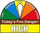 When the Fire Danger rating is “High,” burning of any kind is restricted in Shelby County unless approval is received from local Fire Chief. Controlled burns that are not reported will result in Fire Department being dispatched, and Fires extinguished if determined to be un-safe. Please call 712-755-2124 with questions
Expect to pay more to heat your home this winter than you spent last year. That’s the message from government analysts who sifted through forecasts for a colder winter and slightly higher energy prices. The Energy Department said today (Thursday) that household bills from October through March are likely to be higher for all four main heating fuels – natural gas, electricity, heating oil, and propane.
Consumers got a break last winter, when temperatures were mild. Government meteorologists are expecting a colder winter this time in the Northeast, Midwest and South.
Today: Area of fog this morning; Mostly Sunny. High 59. S @ 10.
Tonight: P/Cldy. Low 38. S @ 5-10.
Tomorrow: P/Cldy. High 68. S @ 10-15.
Saturday: P/Cldy to Cldy w/scattered afternoon showers. High 75.
Sunday: P/Cldy to Cldy w/isolated morning showers. High 70.
Wednesday’s High in Atlantic was 54. We received .06” of an inch of rain. Our 24-hour Low (ending at 7-a.m. today) was 28. Last year on this date, our High in Atlantic was 75 and the low was 37. The Record High in Atlantic on this date was 88 in 1975. The Record Low was 15 in 1907.
Early This Morning: Clear…colder. Widespread frost. Light wind.
Today: Sunny. Widespread frost through mid morning. High in the upper 50s. South wind near 10 mph.
Tonight: Partly cloudy. Not as cool. Low in the lower 40s. South wind 5 to 10 mph.
Friday: Mostly sunny. Warmer. High in the upper 60s. South wind 5 to 15 mph with gusts to around 25 mph.
Friday Night: Mostly cloudy. Warmer. Low around 60. South wind 10 to 15 mph with gusts to around 30 mph.
Saturday: Cloudy. A slight chance of showers and isolated thunderstorms in the morning…then a slight chance of thunderstorms in the afternoon. High in the lower 70s. South wind around 15 mph with gusts to around 30 mph. Chance of precipitation 20 percent.
Sunday: Partly sunny. A slight chance of showers and isolated thunderstorms in the afternoon. High in the upper 70s. Chance of precipitation 20 percent.


