
Today: Variably cloudy w/scattered showers & thunderstorms this morning and again later this afternoon. High 93. S winds becoming W @ 10-15.
Tonight: P/Cldy to Cldy w/scatt. Shwrs & tstrms. Low 70.
Tomorrow: P/Cldy to cldy w/scatt morning showers/thunderstorms. High 86. N @10-15.
Friday/Saturday: P/Cldy. Highs in the upper 80’s.
Tuesday’s High in Atlantic was 93. Our 24-hour Low ending today at 7-a.m., will be 70. (At 5-a.m. we had 82 degrees at KJAN). Last year on this date, the High in Atlantic was 85 and the low was 65. The Record High in Atlantic on this date was 106 in 1939. The Record Low was 47 in 1895 & 1975.
PRAIRIEBURG, Iowa (AP) – Residents in a city in eastern Iowa are raising money to repair a city park destroyed by a tornado that ripped through the community last month. Prairieburg Mayor Arlene Holub tells KWWL-TV that the Baker Community Park is used for many events, including graduation parties and outdoor weddings.
Nonprofit Good Ole’ Boys maintains and runs the park. They’ve started a GoFundMe fundraising campaign to help the rebuilding process. The group has raised about $1,200 of its $20,000 goal as of Tuesday (Today). Residents want the park rebuilt by Labor Day for the city’s annual tractor pull event.
The EF-2 tornado that destroyed the park also damaged nearby homes and businesses. The Enhanced Fujita scale rates the tornado intensity in the country from zero to five, five being the most intense.
Today: Shwrs & tstrms ending this morning; P/Cldy. High 91. S @ 10-20. Heat Index 102. (Heat Advisory from Noon until 8-p.m. for Cass, Adams, Taylor, Ringgold, Pottawattamie, Mills, Montgomery, Fremont and Page Counties)
Tonight: P/Cldy. Low 75. S @ 10-15.
Tomorrow: P/Cldy w/isolated showers/thunderstorms. High 93. S-N @ 10-15.
Thursday: P/Cldy w/scattered shwrs & tstrms. High 88.
Friday: P/Cldy. High near 80.
Monday’s High in Atlantic was 90. Our Low this morning was 69. We received .08″ rain through 5:45-a.m. today. Last year on this date, the High in Atlantic was 90 and the low was 64. The Record High in Atlantic on this date was 104 in 1936. The Record Low was 43 in 1895.
Today: Partly cloudy. High 90. SW-N @ 10-15.
Tonight: P/Cldy. Low 67. N @ 5.
Tomorrow: P/Cldy w/isolated showers/thunderstorms. High around 90. Heat Index around 101. SE @ 10-15.
Wednesday: P/Cldy. High near 95.
Thursday: P/Cldy to Cldy w/scattered shwrs & tstrms. High near 90.
Sunday’s High in Atlantic was 91. Our 24-hour Low ending today at 7-a.m. will be 63 (at 5:20-a.m. it was 76 degrees). Last year on this date, the High in Atlantic was 87 and the low was 72. The Record High in Atlantic on this date was 104 in 1930 & 1936. The Record Low was 46 in 1895 & 1996.
The National Weather Service is warning Iowa residents to be prepared for hot and humid conditions this week. Temperatures in the KJAN listening area are expected to be in the low 90’s this week. The dewpoint, which is a more accurate measure of moisture in the air than the Relative Humidity, will remain consistent at around 70-to 72-degree. The Heat Index (how it feels when the actual temperature and the Dew Point are factored-in) is expected to be anywhere from 100- to 105-degrees across southern Iowa (from the I-80 corridor on south), Monday.
North of I-80, except in the Des Moines (where the Heat Index will be 100-105), it’ll feel more like 90- to 100-degrees through about the Highway 30 corridor, and 85-to 95-degrees from the Iowa/Minnesota border southward to Highway 20 corridor. 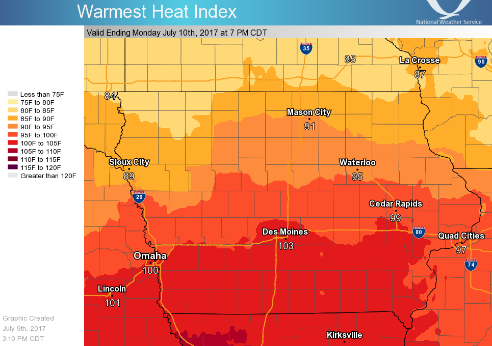
As of mid-afternoon Sunday, no Heat-related advisories or warning had been posted for the area, although south of the Iowa-Missouri line, a Heat Advisory will be in effect from Noon Monday through 7-p.m. Wednesday.
Remember:
A Heat Advisory means that temperatures of at least 100°F* or Heat Index values of at least 105°F* are expected generally within the next 24 hours. Consider postponing or rescheduling any strenuous outdoor activities. If you must be outside, be sure to drink plenty of water and take frequent breaks in the shade. The young and elderly and those with medical conditions should use extra caution outdoors.
An Excessive Heat Watch means that Heat Index values are expected to reach or exceed 110°F* and not fall below 75°F* for at least a 48 hour period, beginning in the next 12 to 48 hours. Plan to suspend all major daytime outdoor activities if a warning is issued. If you do not have air conditioning, locate the nearest cooling shelter or discuss staying with nearby family or friends who have A/C.
An Excessive Heat Warning means that Heat Index values are expected to reach or exceed 110°F* and not fall below 75°F* for at least a 48 hour period, beginning in the next 24 hours. Refrain from outdoor activities of any nature during the warmest time of the day. Drink plenty of water and take frequent breaks if you must be outside. Stay indoors in an air conditioned building as much as possible. Check on elderly family members if they are living alone.
Today: Partly cloudy. High 86. NW @ 5-10.
Tonight: Mostly clear. Low 65. SE @ 5-10.
Tomorrow: P/Sunny w/a 30% chance of afternoon showers/thunderstorms. Hot & humid. High 91. SW @ 5-10.
Sunday night: Mo. Cldy w/a 40% chance of showers & thunderstorms. Low 69.
Monday: P/Cldy w/a 30% chance of morning shwrs & tstrms. Continued hot & humid. High 93.
Tuesday: Mo. Cldy. High 91.
Wednesday: P/Sunny w/a chance of showers & tstorms. High around 90.
Friday’s High in Atlantic was 84. Our Low this morning was 57. Last year on this date, the High in Atlantic was 85 and the low was 59. The Record High in Atlantic on this date was 102 in 1937. The Record Low was 42 in 1908.
Today: Partly cloudy, cooler & less humid. High 85. N @ 10-20.
Tonight: Mostly clear. Low 58.
Tomorrow: P/Cldy. High 85. W @ 10.
Sunday: P/Cldy w/scattered showers & thunderstorms. High 88.
Monday: P/Cldy w/scattered shwrs & tstrms. High 90.
Thursday’s High in Atlantic was 90. Our Low this morning (as of 5-a.m.), was 69. Last year on this date, the High in Atlantic was 83 and the low was 59. The Record High in Atlantic on this date was 107 in 1937. The Record Low was 41 in 1934.
Today: Mostly sunny. High 94. SW @ 10-20.
Tonight: Partly cloudy w/isolated showers & thunderstorms. Low 66. SW-N @ 5-10.
Tomorrow: P/Cldy. High 85. N @ 10-15.
Saturday: P/Cldy. High 85.
Sunday: P/Cldy w/isolated shwrs & tstrms. High 88.
Wednesday’s High in Atlantic was 89. Our Low this morning, 64. Last year on this date, the High in Atlantic was 89 and the low was 64. The Record High in Atlantic on this date was 106 in 1937. The Record Low was 47 in 1967 and 2006.


