
Spring is still several weeks away, but the National Weather Service has released its first look at potential flooding. Senior hydrologist Jeff Zogg says there appear to be few worries right now. “Most of the state — including the Mississippi and Missouri Rivers — we’re seeing a near-normal risk of flood across Iowa. Nothing really abnormal stands out,” Zogg says. There was very little snow on the ground until just recently, and he says that is one of the things they take into account. “The snowpack is definitely a factor that we consider when we look at the risk of flooding in the spring. And the snowpack that we have, that definitely tended to increase the risk, because across much of the state the snowpack has been above normal,” Zogg explains.
The flood risk is based on areas the normally might flood and does not include the possibility of flash flooding brought on by heavy rains. Zogg says water levels in streams and lakes make a difference in the outlook.”Stream levels going into the winter are definitely one thing that we take into account when we look at the risk of flooding,” according to Zogg. “Those were near normal, in some location a little bit below normal, so those tended to have a negligible impact, maybe even decrease the risk a little bit.” He says there are several other factors that could impact any flooding between now and spring. “Future precipitation trends — if we get a lot of snow or a lot of rain for example — that would tend to increase the risk of flooding. So, we’ll just have to keep an eye on that,” Zogg says.
The speed of the warm-up and snowmelt is also a factor, as a gradual melting gives the streams and lakes more time to absorb the runoff from the melting.
(Radio Iowa)
**Winter Weather Advisories in effect – see update on the weather page**
Today: Cloudy w/areas of light rain and drizzle changing to light freezing rain & drizzle. Temps falling to around 32 this morning and in the low 30’s during the day. N @ 10-20.
Tonight: Cloudy w/freezing rain overnight. Low 24. N @ 10-20.
Tomorrow: Light freezing rain/drizzle thru mid-day (total of .1” expected). High 28. N@ 10-20.
Wednesday: P/Cldy. High around 28.
Thursday: Mostly cloudy w/light snow. High near 32.
Sunday’s High in Atlantic was 56. Our Low this morning was 31. We received .08″ of rain/drizzle through 7-a.m. today (24-hour total). Last year on this date our High was 71 and the Low was 32. The record High in Atlantic on this date was 71 in 2017, the Low was -33 in 1936.
Today: Sunny & windy, with a high near 55. S winds @ 20-30 mph w/gusts up to 45, decreasing to 15 to 20 mph later this afternoon. WIND ADVISORY in effect from 9-a.m. until 2-p.m.
Tonight: Increasing clouds, w/a 70% chance of rain, mainly after midnight. Low around 34. South winds @ 5-10mph becoming east northeast after midnight. New precipitation amounts of less than a tenth of an inch possible.
Monday (Washington’s Birthday): Cloudy w/morning rain becoming mixed with and changing over to freezing rain. Little or no ice accumulation is expected. The temperature will be falling into the upper 20’s during the day. North wind 10 to 15 mph, with gusts as high as 20 mph. Chance of precipitation is 60%.
Monday Night: Freezing rain likely, mainly after midnight, otherwise Cloudy, with a low around 22. North wind 10 to 15 mph. Chance of precipitation is 60%. New ice accumulation of 0.1 to 0.2 of an inch possible.
Tuesday: A chance of freezing rain before noon. Mostly cloudy & blustery, with a high near 25. N @ 10-25mph. Chance of precipitation is 30%.
Tuesday Night: Partly cloudy & bluster, with a low around 7.
Wednesday: Sunny, with a high near 25.
The National Weather Service reports warm and very windy conditions are forecast throughout the day Sunday across Iowa. A boundary will set up across southwest to northeast Iowa late Sunday night into Monday, and locations along and northwest will likely experience freezing rain/drizzle during this time frame.
A glaze to near two-tenths of an inch of ice is possible over western to northern Iowa by Monday afternoon. Southeast of this front, rain with an isolated thunderstorm is forecast Monday.(More info. here: http://www.weather.gov/media/dmx/sitreport/SitReport1.pdf) 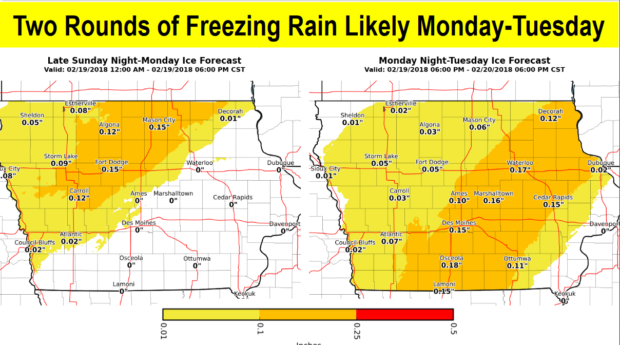
Another round of freezing rain is forecast to develop Monday evening and looks to persist into Tuesday over central to southeast portions of Iowa as the front drifts southeast. Up to one to two-tenths of ice is possible.
In addition to the icing potential, gusty winds of 15 to 25 mph Monday into Tuesday may cause ice coated tree limbs and powerlines to break or fall. Stay tuned to the latest forecast on KJAN or go to http://www.weather.gov/dmx/
Skyscan Forecast Saturday, February 17, 2018 Richard Garuckas
Today: Partly sunny. High 43. Breezy. S @ 10-15 becoming WNW.
Tonight: Mostly clear. Low 24. S @ 5-10.
Sunday: Mostly cloudy, mild. High 55. SSW 15-25 with gusts up to 40mph.
Sunday Night: Cloudy. Rain likely. Low 36.
Monday: Cloudy. Rain and freezing rain likely. High 37.
Tuesday: Mostly cloudy. Slight chance of snow in the morning. High 25.
Wednesday: Mostly sunny. High 27.

Podcast: Play in new window | Download (751.0KB)
Subscribe: RSS
Today: P/Cldy. High 28. NW winds @ 15-25 becoming W @ 10.
Tonight: P/Cldy. Low 18. SW @ 5-10.
Tomorrow: P/Cldy to cldy w/spinkles or flurries. High 40. SW-NW@ 10-20.
Sunday: P/Cldy. High around 50.
Monday: Mostly cloudy w/light rain or drizzle. High near 40.
Thursday’s High in Atlantic was 44. Our Low this morning (as of 5:30-a.m.), was 12. Last year on this date our High was 64 and the Low was 29. The record High in Atlantic on this date was 64 in 2017, the Low was -33 in 1958.
Today: Areas of fog possible this morning; P/Cldy to Cldy. High 42. N @ 10-15.
Tonight: P/Cldy. Low 10. N @ 15-25.
Tomorrow: P/Cloudy. High 28. NW @ 10-15.
Saturday: Mo. Cldy. High 38.
Sunday: P/Cloudy. High near 48.
Wednesday’s High in Atlantic was 44. Our Low was 32. Last year on this date our High was 47 and the Low was 25. The record High in Atlantic on this date was 72 in 1921, the Low was -31 in 1905.
Today: Areas of fog possible this moring; Partly cloudy. High 45. SW @ 10-20.
Tonight: P/Cldy. Low 30. S @ 5-10.
Tomorrow: Mostly Cloudy. High 42. N @ 10-15.
Friday: P/Cldy. High 28.
Saturday: Cloudy. High near 40.
Tuesday’s High in Atlantic was 38. Our Low was 15. Last year on this date our High was 49 and the Low was 25. The record High in Atlantic on this date was 68 in 1934, the Low was -20 in 1936.
Today: Partly cloudy to cloudy. High around 33. S @ 10-15.
Tonight: P/Cldy. Low 25. S @ 5-10.
Tomorrow: P/Cldy. High 45. SW @ 10-20.
Thursday: Mostly cloudy w/a chance of light rain. High 40.
Friday: Cloudy. High 29.
Monday’s High in Atlantic was 19. (Temps rose overnight and by 5-a.m. today it was 20 degrees). Our Low was 1. Last year on this date our High was 49 and the Low was 23. The record High in Atlantic on this date was 63 in 1934, the Low was -30 in 1905.
Today: Partly cloudy. High around 21. NE @ 5-10.
Tonight: P/Cldy. Low 10. SE @ 5-10.
Tomorrow: P/Cldy. High 33. S @ 10-15.
Wednesday: P/Cldy. High 45.
Thursday: Cloudy w/a chance of light rain or snow. High 38.
Sunday’s High in Atlantic was 22. Our Low this morning (as of 5-a.m.) was -2. Last year on this date our High was 47 and the Low was 21. The record High in Atlantic on this date was 72 in 1990, the Low was -24 in 1986 & 1988.


