
Today: Partly cloudy. High around 54. NE @ 10.
Tonight: Cloudy w/light rain late. Low 34. E @ 10.
Tomorrow: Cldy w/rain. High 42. E/SE @ 15-25.
Saturday: Mostly cloudy w/light snow early. High 42.
Sunday: P/Cldy. High near 50.
Wednesday’s High in Atlantic was 66. Our Low this morning was 24. Last year on this date our High was 38 and the Low was 12. The record High in Atlantic on this date was 79 in 2003. The Record Low was 0, in 1948 and 1944.
The National Weather Service has issued a “Red Flag Warning,” for the southwest corner of Iowa. The warning currently affects Fremont and Page Counties, where potentially dangerous fire weather conditions will exist this afternoon. The warning is in effect from 1-p.m. today until 7-p.m.
Gusty southwest winds (at 15-to 25-mph) combined with low relative humidity values and dry fuels, will result in dangerous fire weather conditions across parts of southeastern Nebraska and southwestern Iowa this afternoon. As temperatures climb well into the 60s today, humidity levels will drop below 20 percent. These low relative humidity values, along with southwest winds gusting to 25 mph, will make any fires that develop difficult to control.
A Red Flag Warning means that critical fire weather conditions are either occurring now, or will shortly. A combination of strong winds, low relative humidity and warm temperatures can contribute to extreme fire behavior.
Skyscan Forecast – Dan Hicks – Wednesday, 3/14/2018
Today: Mostly sunny. High around 60. SW @ 10-20.
Tonight: Partly cloudy. Low 30. N @ 5-10.
Tomorrow: P/Cldy to Cldy. High 52. SE @ 10.
Friday: Mostly cloudy w/light rain. High 42.
Saturday: Mo. Cldy w/light snow or flurries early. High 42.
Tuesday’s High in Atlantic was 46. Our Low this morning, 16. Last year on this date, the High was 32 and the Low was 11. The Record High for today’s date in Atlantic was 78 in 2012, and the Record Low was -12 in 1975.
Today: Mostly sunny. High 44. N @ 10.
Tonight: Mostly clear. Low 20.
Tomorrow: P/Cldy. High near 60. SW @ 10-20.
Thurssday: Mostly cloudy. High 52.
Friday: Mo. Cldy w/light rain. High 44.
Monday’s High in Atlantic was 49. Our Low this morning (as of 5-a.m.) was 222. Last year on this date our High was 25 and the Low was 11. The record High in Atlantic on this date was 79 in 2012. The Record Low was -11, in 1948 and 1975.
Today: Partly cloudy. High 44. NW @ 10-15.
Tonight: Mostly clear. Low 18. NW @ 5.
Tomorrow: P/Cldy. High 42. NW @ 10.
Wednesday: P/Cldy. High near 60.
Thursday: Mo. Cldy. High 52.
Sunday’s High in Atlantic was 39. Our Low this morning, 29 (as of 5:25-a.m.). We received a trace of snowfall Sunday morning, in Atlantic. Last year on this date our High was 38 and the Low was 24. The record High in Atlantic on this date was 74 in 1938. The Record Low was -21, in 1998.
Today: Cloudy w/a 60% chance of snow, mainly before 10am. High near 41. N/NE wind 5 to 10 mph. New snow accumulation of less than a half inch possible.
Tonight: Cloudy to partly cloudy, with a low around 24. North northwest wind around 10 mph.
Monday: Sunny, with a high near 45. Northwest wind 10-20 mph.
Monday Night: Partly cloudy, with a low around 20. North wind around 10 mph.
Tuesday: Sunny, with a high near 39.
Tuesday Night: Mostly clear, with a low around 19.
Wednesday: Sunny, with a high near 54.
Wednesday Night: Mostly clear, with a low around 33.
Saturday’s High in Atlantic was 49. Snow began at around 6-a.m. Our Low this morning was 30. Last Year on this date, the High in Atlantic was 30 and the Low was 20. The Record High in Atlantic on this date was 69 in 1900, and the Record Low was -22 in 1948.
Today: P/Cldy to Cldy w/a 30% chance of afternoon showers. High 47. SE @ 5-10.
Tonight: Cloudy w/rain changing to snow. Low 31. NE @ 5-10.
Tomorrow: Cldy w/snow-rain mix. High 37. N @ 5-10. (1-2” snow possible, total)
Sunday night: P/Cldy. Low 23.
Monday: Mostly Sunny. High 41.
Tuesday: Mo. Sunny. High 42.
Wednesday: Mo. Sunny. High 51.
Friday’s High in Atlantic was 45. Our Low was 24. Last year on this date our High was 28 and the Low was 15. The record High in Atlantic on this date was 75 in 2015. The Record Low was -8, in 1948.
The National Weather Service says a winter system is likely to bring snow to portions of Iowa Saturday evening through Sunday morning. Confidence in the timing of this event is high. However, confidence is low to medium regarding the location of potential higher amounts of snow. At this time, it appears 1 to 2 inches of snow will in an area roughly along and south of Interstate 80, with around 1 inch falling across the rest of our area.
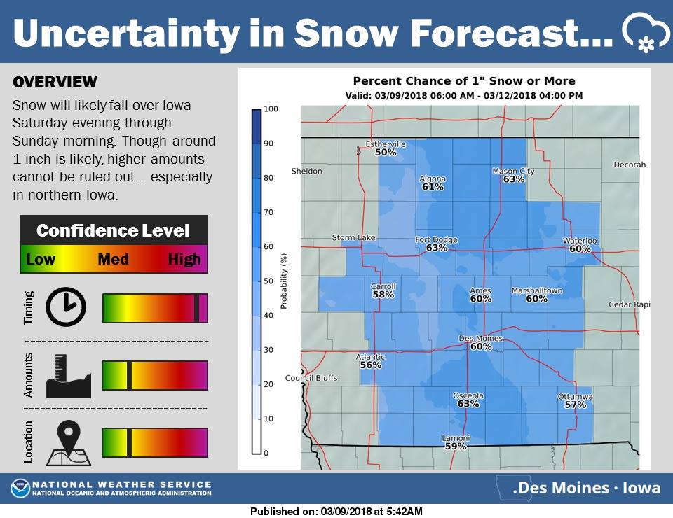 There is a chance, however, that higher totals of snow may fall across northern Iowa. In this scenario, most of the snow will fall overnight Saturday, leading to potentially slippery roads and hazardous travel Saturday night into Sunday morning. Keep it tuned here today as we will have a more accurate and higher confidence forecast by this afternoon. For next week, quiet weather conditions and above normal temperatures are expected. By next Thursday and Friday, highs in the 50s and even 60s is possible! Again, check back throughout today and this weekend, for forecast updates.
Today: P/Cldy to Cldy. High 42. SE @ 10-15.
Tonight: Mo. cloudy. Low 30. SE @ 5-10.
Tomorrow: Cldy w/light rain mainly during the afternoon. High 45. SE @ 10-20,
Sunday: Mostly cloudy w/light snow or flurries in the morning. High 36
Monday: P/Cldy. High 42.
Thursday’s High in Atlantic was 37. Our Low (thru 5-a.m. today) was 14 (at 5-a.m., it was 27). Last year on this date our High was 49 and the Low was 15. The record High in Atlantic on this date was 76 in 1986. The Record Low was -10, in 1912.
Today: Partly sunny. High 38. NW @ 10-15.
Tonight: Partly cloudy. Low 20. SE @ 5.
Tomorrow: P/Cldy. High 42. SE @ 10-15.
Saturday: Mostly cloudy w/light rain late. High 45
Sunday: Mostly cloudy w/light snow or flurries. High 36.
Wednesday’s High in Atlantic was 30. Our Low this morning was 14. We received a Trace of snow yesterday, in Atlantic, with some occasional flurries. Last year on this date our High was 55 and the Low was 29. The record High in Atlantic on this date was 76 in 1986. The Record Low was -12, in 1982.


