
Severe Thunderstorm Warning
IAC015-049-073-077-153-070000-
/O.NEW.KDMX.SV.W.0105.180606T2257Z-180607T0000Z/
BULLETIN - IMMEDIATE BROADCAST REQUESTED
Severe Thunderstorm Warning
National Weather Service Des Moines IA
557 PM CDT WED JUN 6 2018
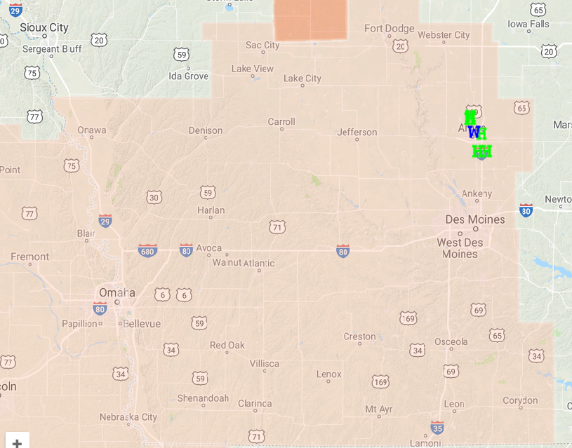
The National Weather Service in Des Moines has issued a
* Severe Thunderstorm Warning for...
Northwestern Polk County in central Iowa...
Southeastern Greene County in west central Iowa...
Guthrie County in west central Iowa...
Southern Boone County in central Iowa...
Dallas County in central Iowa...
* Until 700 PM CDT.
* At 556 PM CDT, severe thunderstorms were located along a line
extending from near Big Creek Lake to 7 miles west of Perry, moving
south at 35 mph.
HAZARD...70 mph wind gusts and quarter size hail.
SOURCE...Radar indicated.
IMPACT...Hail damage to vehicles is expected. Expect considerable
tree damage. Wind damage is also likely to mobile homes,
roofs, and outbuildings.
* Locations impacted include...
West Des Moines, Urbandale, Clive, Waukee, Grimes, Perry,
Jefferson, Adel, Guthrie Center, Madrid, Stuart, Dallas Center,
Earlham, Granger, Panora, De Soto, Woodward, Van Meter, Jordan
Creek Town Center and Lake Panorama.
This includes Interstate 80 between mile markers 100 and 121.
PRECAUTIONARY/PREPAREDNESS ACTIONS...
For your protection move to an interior room on the lowest floor of a
building.
Prepare immediately for large hail and damaging winds. People outside
should move immediately to shelter inside a strong building. Stay
away from windows.
Large hail and damaging winds and continuous cloud to ground
lightning is occurring with these storms. Move indoors immediately.
Lightning is one of nature`s leading killers. Remember, if you can
hear thunder, you are close enough to be struck by lightning.
&&
A Severe Thunderstorm Watch has been issued until 10-p.m. for the following counties in the KJAN listening area: ADAIR ADAMS AUDUBON CARROLL CASS CRAWFORD DALLAS FREMONT GUTHRIE HARRISON MADISON MILLS MONONA
MONTGOMERY PAGE POTTAWATTAMIE RINGGOLD SAC SHELBY TAYLOR and UNION.
Severe Thunderstorm Watch until 10-p.m. for areas shaded in light mauve/pink
A Severe thunderstorm watch means conditions are favorable for the development of severe storms in and close to the watch area. The primary threat from any storms that develop this evening and tonight appear to be damaging winds, dangerous hail and heavy rain.
Stay tuned for further weather updates and prepare to seek shelter should severe weather threaten.
A severe thunderstorm by definition is a thunderstorm that produces one inch hail or larger in diameter and/or winds equal or exceed 58 miles an hour.
Strong to severe thunderstorms remain forecast today into tonight for the KJAN listening area. Large hail and damaging thunderstorm wind gusts look to be the main threat later this afternoon into tonight. Heavy rain is also anticipated and may lead to localized flash flooding by tonight. The weather pattern will stay active Thursday into the weekend with periodic chances for thunderstorms. Severe weather potential is forecast Thursday and Friday. 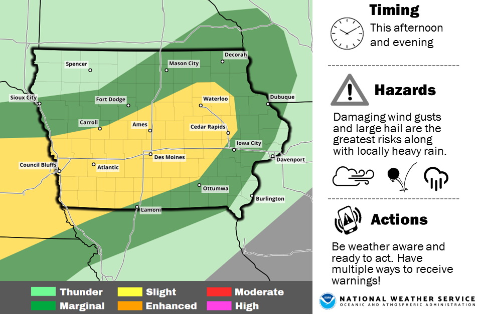
Today: Party cloudy, warm & humid w/isolated showers & thunderstorms. High 92. S @ 10-20mph.
Tonight: Variably cloudy w/scattered shwrs & tstrms. Low 70.
Tomorrow: V/Cldy w/scatt. shwrs & tstrms. High 88. E @ 5-10.
Friday: P/Cldy w/scatt. shwrs & tstrms in the morning. High 90.
Saturday: P/Cldy w/scatt. shwrs & tstrms. High 90.
A native of the “Show-Me State” is Iowa’s new state climatologist. Justin Glisan grew up in Saint Charles, Missouri and says his interest in climate science started at an early age – with a little lecture from his father. “I was scared to death of severe weather and we had a bout of really bad storms when I was four or five,” Glisan said. “My father took me aside and said, ‘you either learn all you can about weather and climate or you’re just going to be scared the rest of your life.'”

Justin Glisan
The 35-year-old Glisan HAS learned a lot about weather. He earned bachelor’s and master’s degrees in atmospheric science at the University of Missouri and a PhD at Iowa State University in 2012. Since then, he’s worked as a researcher at ISU. Glisan is now Iowa’s third state climatologist. He replaces Harry Hillaker, who recently retired after three decades in the position. Glisan is hoping to hold the job for a similar amount of time. “Climatology is the study of, you know, a long time period. A climatological decade is 30 years, so I hope to be here a climatological decade or maybe a little more than that,” Glisan said.
The state climatologist monitors weather activity to compile weekly, monthly, and annual reports about precipitation totals, shifts in temperatures, and other climate-related data. According to Glisan, Iowa is one of the more exciting places in the country to monitor changes in the climate. “We’re right in the middle of the country. The moisture gate is the Gulf of Mexico. We get cold air from the high latitudes…flowing off the west coast monsoons in Arizona – all that kind of stuff. So, yeah, we’re in a very interesting part of the country,” Glisan said.
The state climatologist’s office is part of the Iowa Department of Agriculture. Glisan lives in Des Moines with his wife, Maggie, who is Senior Food Editor for Better Homes and Gardens magazine.
(Radio Iowa)
Today: Partly cloudy. High 90. S @ 10-20.
Tonight: P/Cldy. Low 67. Winds S @ 5-10.
Tomorrow: P/Cldy w/isolated thunderstorms possible. High 92. S @ 10-20.
Thursday & Friday: Variably cloudy w/scattered showers & thunderstorms. Highs both days around 90.
Monday’s High in Atlantic was 78. Our Low was 55. Last year, the High and Low was 91 and 58. The All-Time Record High in Atlantic on June 5th, was 104 in 1933. The Record Low was 40 in 1897 & 1935.
Today: Partly cloudy. High 82. S @ 10.
Tonight: P/Cldy. Low 60. Winds S @ 5.
Tomorrow: P/Cldy. High 90. SW @ 10-15.
Wednesday: P/Cldy. High 92.
Thursday: P/Cldy w/isolated thundershowers. High 92.
Yesterday’s High in Atlantic was 81. Our Low this morning (as of 5-a.m.) was 49. Last year on this date our High was 94 and the Low was 53. The record High in Atlantic on this date was 96 in 1914. The Record Low was 31, in 1945.
Today: Sunny & windy. High near 79. Northwest wind 5-15mph w/gusts to near 30 this afternoon.
Tonight: Clear. Low around 54. NW winds becoming light and variable.
Monday: Mostly sunny. High near 81. SE/S @ 5-10.
Monday Night: Mostly clear, with a low around 59. South wind 5 to 10 mph.
Tuesday: Sunny, with a high near 89. South southwest wind 5 to 10 mph.
Tuesday Night: Mostly clear, with a low around 64.
Wednesday: Mostly sunny, with a high near 91.
Saturday’s High in Atlantic was 78. Our Low this morning, 54. Last Year on this date, the High in Atlantic was 89 and the Low was 62. The Record High for June 3rd in Atlantic was 93 in 1911, and the Record Low was 32, in 1969.
Much of the state came under an air quality alert Friday. The Iowa Department of natural Resources issued the warning over high ozone levels. Iowa D-N-R environmental specialist Sean Fitzsimmons says ozone levels rise with warm temperatures and clear skies. “When we have an eight hour average when the ozone level exceeds 70 parts per billion that’s a level that falls in the sensitive groups category.”
Fitzsimmons says most people can go about their business without noticing any problem. “A typical person wouldn’t have difficulties at those levels but if you had an asthmatic child or elderly individual or people with respiratory problems, some of those large sensitive groups will start to have issues with breathing difficulties at those levels.”
He says ozone levels fall at night and when clouds move into the forecast.
(Radio Iowa)
Severe storms pummeled western and southwest Iowa with strong winds, heavy rain and dangerous cloud to ground lightning, early this morning. Here in Atlantic, winds at the airport gusted up to 66 miles per hour at around 1:55-a.m. There were also scattered power outages and numerous tree debris on the streets. A power line was on the ground at around 2:41-a.m. in the 600 block of Palm Street. Atlantic Fire responded to the scene. And, social media posts report a tree limb fell very close to the side of a house, landing on a set of steps.
Tree limbs were blocking some streets in Council Bluffs at around 12:50-a.m. today. In Monona County, a semi tractor-trailer was blown over on Interstate 29 at around 12:15.am., three-miles south/southwest of Blencoe. A 60-mph gust of wind was recorded near Little Sioux, in Harrison County, at about the same time. Thunderstorm wind damage was reported in Sarpy and Douglas Counties in Nebraska, between midnight at 1-a.m., as well. There were numerous other reports of high winds and damage scattered across Nebraska. Mid-American Energy reported there were scattered power outages across southwest Iowa. The latest report indicated 313 residences were affected (as of 6:15-a.m.). Nishnabotna Valley REC reports 113 people were without power in Pottawattamie County, 14 in Cass County, 8 in Shelby County, 1 in Audubon County, and seven others total in Montgomery, Adams and Taylor Counties.
No injuries were immediately reported.


