
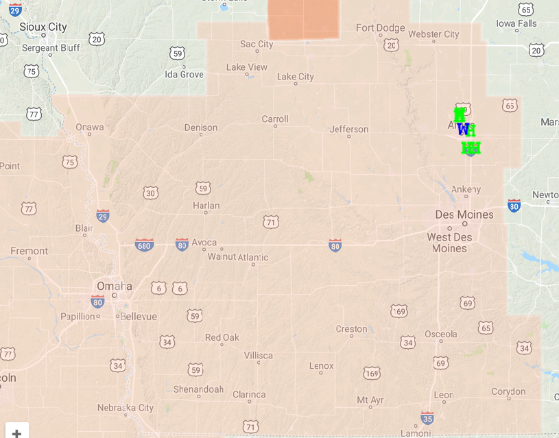
Cass IA-Guthrie IA-Audubon IA-Adair IA-
805 PM CDT WED JUN 6 2018

...A SEVERE THUNDERSTORM WARNING REMAINS IN EFFECT UNTIL 845 PM CDT
FOR CASS...SOUTHERN GUTHRIE...SOUTHERN AUDUBON AND ADAIR COUNTIES...

At 805 PM CDT, severe thunderstorms were located along a line
extending from 8 miles east of Walnut to 10 miles south of Stuart,
moving south at 20 mph.

HAZARD...60 mph wind gusts and quarter size hail.

SOURCE...Trained weather spotters.

IMPACT...Hail damage to vehicles is expected. Expect wind damage to
         roofs, siding, and trees.

Locations impacted include...
Atlantic, Greenfield, Stuart, Griswold, Anita, Exira, Adair,
Fontanelle, Elk Horn, Dexter, Lewis, Casey, Orient, Diamondhead Lake,
Massena, Menlo, Kimballton, Cumberland, Bridgewater and Brayton.

This includes Interstate 80 between mile markers 50 and 97.

PRECAUTIONARY/PREPAREDNESS ACTIONS...

For your protection move to an interior room on the lowest floor of a
building.

Continuous cloud to ground lightning is occurring with these storms.
Move indoors immediately. Lightning is one of nature`s leading
killers. Remember, if you can hear thunder, you are close enough to
be struck by lightning.
Severe Thunderstorm Warning
National Weather Service Des Moines IA
745 PM CDT WED JUN 6 2018

The National Weather Service in Des Moines  has issued a

* Severe Thunderstorm Warning for...
  Cass County in southwestern Iowa...
  Southern Guthrie County in west central Iowa...
  Southern Audubon County in west central Iowa...
  Adair County in southwestern Iowa...

* Until 845 PM CDT.

* At 745 PM CDT, severe thunderstorms were located along a line
  extending from 11 miles northeast of Walnut to near Stuart, moving
  south at 20 mph.

  HAZARD...60 mph wind gusts and quarter size hail.

  SOURCE...Radar indicated.

  IMPACT...Hail damage to vehicles is expected. Expect wind damage
           to roofs, siding, and trees.

* Locations impacted include...
  Atlantic, Greenfield, Stuart, Griswold, Anita, Exira, Adair,
  Fontanelle, Elk Horn, Dexter, Lewis, Casey, Orient, Diamondhead
  Lake, Massena, Menlo, Kimballton, Cumberland, Bridgewater and
  Brayton.

This includes Interstate 80 between mile markers 50 and 97.
Guthrie IA-Audubon IA-Adair IA-Cass IA-
725 PM CDT WED JUN 6 2018

...GUSTY WINDS TO 40 MPH AND DIME HAIL POSSIBLE...

At 724 PM CDT, Doppler radar was tracking strong thunderstorms along
a line extending from 6 miles east of Irwin to near Stuart. Movement
was south at 15 mph.

Dime size hail and winds in excess of 40 mph will be possible with
these storms.

Locations impacted include...
Audubon, Guthrie Center, Stuart, Anita, Exira, Adair, Elk Horn,
Dexter, Casey, Diamondhead Lake, Menlo, Kimballton, Brayton, Audubon
County Airport, Anita Municipal Airport and Lake Anita State Park.

PRECAUTIONARY/PREPAREDNESS ACTIONS...

Frequent cloud to ground lightning is occurring with these storms.
Lightning can strike 10 miles away from a thunderstorm. Seek a safe
shelter inside a building or vehicle.

These storms may intensify, so be certain to monitor local radio
stations and available television stations for additional information
and possible warnings from the National Weather Service.

&&

A Severe Thunderstorm Watch remains in effect until 1000 PM CDT for
central, south central, southwestern and west central Iowa.
Severe Thunderstorm Warning
National Weather Service Des Moines IA
629 PM CDT WED JUN 6 2018

The National Weather Service in Des Moines  has issued a

* Severe Thunderstorm Warning for...
  Northwestern Audubon County in west central Iowa...
  Southeastern Crawford County in west central Iowa...
  Southwestern Carroll County in west central Iowa...

* Until 730 PM CDT.

* At 628 PM CDT, a severe thunderstorm was located over Manning, or
  14 miles east of Denison, moving south at 10 mph.

  HAZARD...Ping pong ball size hail and 60 mph wind gusts.

  SOURCE...Radar indicated.

  IMPACT...People and animals outdoors will be injured. Expect hail
           damage to roofs, siding, windows, and vehicles. Expect
           wind damage to roofs, siding, and trees.

* Locations impacted include...
  Manning, Templeton, Halbur, Gray, Aspinwall and Manning Municipal
  Airport.

PRECAUTIONARY/PREPAREDNESS ACTIONS...

Prepare immediately for large hail and deadly cloud to ground
lightning. Seek shelter inside a well-built structure. Stay away from
windows.
Severe Thunderstorm Warning
IAC015-049-073-077-153-070000-
/O.NEW.KDMX.SV.W.0105.180606T2257Z-180607T0000Z/

BULLETIN - IMMEDIATE BROADCAST REQUESTED
Severe Thunderstorm Warning
National Weather Service Des Moines IA
557 PM CDT WED JUN 6 2018

The National Weather Service in Des Moines  has issued a

* Severe Thunderstorm Warning for...
  Northwestern Polk County in central Iowa...
  Southeastern Greene County in west central Iowa...
  Guthrie County in west central Iowa...
  Southern Boone County in central Iowa...
  Dallas County in central Iowa...

* Until 700 PM CDT.

* At 556 PM CDT, severe thunderstorms were located along a line
  extending from near Big Creek Lake to 7 miles west of Perry, moving
  south at 35 mph.

  HAZARD...70 mph wind gusts and quarter size hail.

  SOURCE...Radar indicated.

  IMPACT...Hail damage to vehicles is expected. Expect considerable
           tree damage. Wind damage is also likely to mobile homes,
           roofs, and outbuildings.

* Locations impacted include...
  West Des Moines, Urbandale, Clive, Waukee, Grimes, Perry,
  Jefferson, Adel, Guthrie Center, Madrid, Stuart, Dallas Center,
  Earlham, Granger, Panora, De Soto, Woodward, Van Meter, Jordan
  Creek Town Center and Lake Panorama.

This includes Interstate 80 between mile markers 100 and 121.

PRECAUTIONARY/PREPAREDNESS ACTIONS...

For your protection move to an interior room on the lowest floor of a
building.

Prepare immediately for large hail and damaging winds. People outside
should move immediately to shelter inside a strong building. Stay
away from windows.

Large hail and damaging winds and continuous cloud to ground
lightning is occurring with these storms. Move indoors immediately.
Lightning is one of nature`s leading killers. Remember, if you can
hear thunder, you are close enough to be struck by lightning.

&&
A Severe Thunderstorm Watch has been issued until 10-p.m. for the following counties in the KJAN listening area: ADAIR ADAMS AUDUBON CARROLL CASS CRAWFORD DALLAS FREMONT GUTHRIE HARRISON MADISON MILLS MONONA
MONTGOMERY PAGE POTTAWATTAMIE RINGGOLD SAC SHELBY TAYLOR and UNION.
Severe Thunderstorm Watch until 10-p.m. for areas shaded in light mauve/pink
A Severe thunderstorm watch means conditions are favorable for the development of severe storms in and close to the watch area. The primary threat from any storms that develop this evening and tonight appear to be damaging winds, dangerous hail and heavy rain.
Stay tuned for further weather updates and prepare to seek shelter should severe weather threaten.
A severe thunderstorm by definition is a thunderstorm that produces one inch hail or larger in diameter and/or winds equal or exceed 58 miles an hour.
Strong to severe thunderstorms remain forecast today into tonight for the KJAN listening area. Large hail and damaging thunderstorm wind gusts look to be the main threat later this afternoon into tonight. Heavy rain is also anticipated and may lead to localized flash flooding by tonight. The weather pattern will stay active Thursday into the weekend with periodic chances for thunderstorms. Severe weather potential is forecast Thursday and Friday. 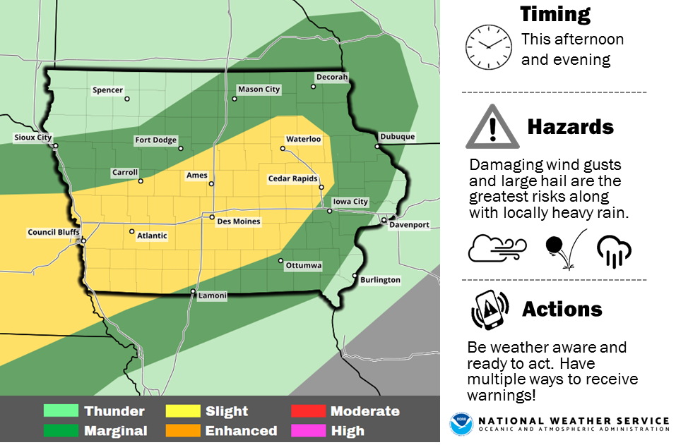
Today: Party cloudy, warm & humid w/isolated showers & thunderstorms. High 92. S @ 10-20mph.
Tonight: Variably cloudy w/scattered shwrs & tstrms. Low 70.
Tomorrow: V/Cldy w/scatt. shwrs & tstrms. High 88. E @ 5-10.
Friday: P/Cldy w/scatt. shwrs & tstrms in the morning. High 90.
Saturday: P/Cldy w/scatt. shwrs & tstrms. High 90.
A native of the “Show-Me State” is Iowa’s new state climatologist. Justin Glisan grew up in Saint Charles, Missouri and says his interest in climate science started at an early age – with a little lecture from his father. “I was scared to death of severe weather and we had a bout of really bad storms when I was four or five,” Glisan said. “My father took me aside and said, ‘you either learn all you can about weather and climate or you’re just going to be scared the rest of your life.'”

Justin Glisan
The 35-year-old Glisan HAS learned a lot about weather. He earned bachelor’s and master’s degrees in atmospheric science at the University of Missouri and a PhD at Iowa State University in 2012. Since then, he’s worked as a researcher at ISU. Glisan is now Iowa’s third state climatologist. He replaces Harry Hillaker, who recently retired after three decades in the position. Glisan is hoping to hold the job for a similar amount of time. “Climatology is the study of, you know, a long time period. A climatological decade is 30 years, so I hope to be here a climatological decade or maybe a little more than that,” Glisan said.
The state climatologist monitors weather activity to compile weekly, monthly, and annual reports about precipitation totals, shifts in temperatures, and other climate-related data. According to Glisan, Iowa is one of the more exciting places in the country to monitor changes in the climate. “We’re right in the middle of the country. The moisture gate is the Gulf of Mexico. We get cold air from the high latitudes…flowing off the west coast monsoons in Arizona – all that kind of stuff. So, yeah, we’re in a very interesting part of the country,” Glisan said.
The state climatologist’s office is part of the Iowa Department of Agriculture. Glisan lives in Des Moines with his wife, Maggie, who is Senior Food Editor for Better Homes and Gardens magazine.
(Radio Iowa)
Today: Partly cloudy. High 90. S @ 10-20.
Tonight: P/Cldy. Low 67. Winds S @ 5-10.
Tomorrow: P/Cldy w/isolated thunderstorms possible. High 92. S @ 10-20.
Thursday & Friday: Variably cloudy w/scattered showers & thunderstorms. Highs both days around 90.
Monday’s High in Atlantic was 78. Our Low was 55. Last year, the High and Low was 91 and 58. The All-Time Record High in Atlantic on June 5th, was 104 in 1933. The Record Low was 40 in 1897 & 1935.


