
AMES, Iowa (AP) — Heavy rain has washed over much of Story and eastern Boone County, prompting flash flood warnings. The National Weather Service issued a warning Thursday morning after more than 4 inches (10 centimeters) of rain had fallen and 2 more inches had been forecast. The deluge caused street flooding across the Iowa State University campus and elsewhere in Ames, stranding some vehicles and their drivers. Street flooding also was reported in Kelley, Nevada and Story City. U.S. Highway 69 was forced to close for a short time on a stretch south of Ames. A flash flood warning also has been issued for several counties to the northwest, including Calhoun, Humboldt, Pocahontas and Webster.
Another big change in the weather is coming, one that’ll feel like it’s mid-summer, though we still have a week of spring left. Meteorologist Kurt Kotenberg, at the National Weather Service in metro Des Moines, says yes, it was already really hot a few weeks ago, but the next several days promise to be the hottest of the year so far. “There’s very high confidence that temperatures will be in the middle 90s Friday, Saturday, Sunday and Monday,” Kotenberg says. “Heat index values will be pushing anywhere between 100 and 105 degrees in the metro area and across most of the state we’ll be pushing triple digits.”
He reminds, it’s not even summer yet. That season officially arrives next Thursday but Mother Nature doesn’t always follow the calendar. “Basically, starting tomorrow — Friday, lasting into Saturday, lasting into Sunday and probably lasting into Monday, we’re going to have some of the hottest temperatures of the year here in Iowa,” Kotenberg says. “The past couple of weeks, it’s been well above average, but this is probably going to be the hottest air that we’ve had.”
It’s been a strange few months for weather, after a prolonged winter with late snows, a shortened spring and an early summer. If you think this seems like way too hot of a forecast for this early in the year, you’re right. “In Des Moines, the normal high is 81 degrees. Up in Waterloo, the normal high is right around 78 and our forecast is in the middle 90s, maybe even the upper 90s,” Kotenberg says. “We’re going to be a solid 15 degrees above normal for temperatures.” Due to the forecast, he says it’s likely statewide heat advisories will be issued soon for the steamy days ahead. “Heat index values are going to be over 100, pushing 105 degrees, and it’s really the consecutive days of this that cause the problems,” Kotenberg says. “Temperatures overnight won’t cool much below the low to mid-70s. When you compound things like this is where we really start to run into the heat issues, health-wise.”
A few tips to handle the heat: Wear light-weight and light-colored clothes. Drink plenty of water. If you’ll be working outside, take frequent breaks. Never leave children or pets inside vehicles. Make sure pets and livestock have access to water. Also, check on your friends and neighbors, especially the elderly, to make sure they’re doing okay.
(Radio Iowa)
Today: Variably cloudy w/scattered showers & thunderstorms. High 87. S/SE @ 10-20.
Tonight: Partly cloudy. Low 70. SE @ 5-10.
Tomorrow: P/cldy, warm & humid. High 94. S @ 15-25.
Saturday: P/Cldy. High 96.
Sunday: P/Cldy. High 94.
Yesterday’s High in Atlantic was 82. Our Low was 61. Last year on this date our High was 85 and the Low was 58. The record High in Atlantic on this date was 97 in 1987. The Record Low was 41, in 1933.
OMAHA, Neb. (AP) — The National Weather Service has confirmed that five tornadoes touched down in eastern Nebraska and one in western Iowa, Monday evening, but they caused little damage. There were also no injuries, only minor damage, and were rated EF-0, with winds from 65 through 85 mph. There were tornadoes in Nebraska, around Louisville and Murray. One touched down near Elk Creek and one near Table Rock. The sixth was spotted in southwest Iowa, west of Thurman.
It’ll be a dark and likely stormy night across western Iowa. The National Weather Service in Des Moines reports scattered thunderstorms are forecast to spread from western into central Iowa late tonight (Wednesday), and Thursday morning. The severe weather threat is low, but a few stronger storms could produce hail and gusty winds. Slight chances for more thunderstorms are forecast across parts of northern Iowa late Thursday night into Friday morning and again late Friday night into Saturday morning, once again with a low probability of severe weather.
Today: Partly cloudy. High 83. N winds becoming SE @ 10-15.
Tonight: P/Cldy to Cldy w/scattered shwrs & tstrms. Low 65. SE @ 5-10.
Tomorrow: Shwrs & tstrms ending early; Becoming P/Cldy. High 85. SE @ 10-15.
Friday: Mostly sunny. High 94,
Saturday: Mo. Sunny. High 96.
Yesterday’s High in Atlantic was 85. Our Low this morning was 60. Last year on this date the High in Atlantic was 92 and the Low was 64. The record High in Atlantic on this date was 96 in 1987. The Record Low was 37, in 1906.
Better enjoy the current temperature and slightly lower humidity we’re experiencing, because the National Weather says HOT and HUMID weather begins Friday, and will last into the weekend. Heat index values over 100°F each can afternoon can be expected! 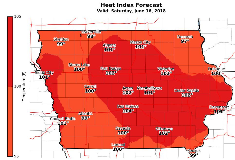 (Click on the image to enlarge)
OMAHA, Neb. (AP) — Thunderstorms that blasted through eastern Nebraska into Iowa toppled trees, overturned semitrailers, knocked out power to hundreds of homes and businesses and spawned short-lived tornadoes. The National Weather Service says two drivers were taken to a hospital and other drivers suffered minor injuries Monday when straight-line winds topping 80 mph knocked over nine semis on Interstate 29 in western Iowa. The post office in Sidney, Iowa, lost its roof. Three farm storage buildings were destroyed three-miles south of Thurman, in Fremont County, and shingles were blown off of homes in the Montgomery County town of Coburg. In Red Oak, winds gusted to near 60-miles per hour, while in Bedford, Clarinda and New Market, winds of 60-to 70mph were reported.
Authorities say several homes were damaged in the Lake Waconda community in Cass County, Nebraska. Brief tornado touchdowns were reported near Cedar Creek, Louisville, Murray and Table Rock.
Hail the size of golf balls was reported in the Gretna area.
Today: Some areas of fog possible this morning; P/Cldy. High 86. NW @ 10-15.
Tonight: Fair to P/Cldy. Low 57. Winds light & variable.
Tomorrow: P/Cldy. High 84. SE @ 10.
Thursday: Variably Cldy w/scatt. Shwrs & tstrms. High 84.
Friday: Shwrs & tstrms early; Becoming P/Cldy, warm & humid. High 92.
Yesterday’s High in Atlantic was 80. Our Low this morning 66. We received .36” rain Monday & Monday night. Last year on this date our High was 87 and the Low was 73. The record High in Atlantic on this date was 95 in 1892. The Record Low was 38, in 1903.
8:21-p.m. Tstrm wind gust est. 65-70 mph estimated by radar, 4 miles N. of New Market in Taylor County; Law enforcement report
8:30-p.m. Estimated 70 mph wind 9 miles sw of Bedford in Taylor Co.; Trained spotter report.
8:01-to 8:15-p.m. 62-68 mph gusts of wind reported in Clarinda.
7:38-p.m. Thunderstorm winds est. at 58 mph 1 mile w/nw of Red Oak.
7:28-p.m. Shingles blown off homes in Coburg (Montgomery County). 1′ diameter tree limbs reported down.
7:15-p.m. Three farm storage buildings destroyed 3 miles s. of Thurman, in Fremont County
7:00-p.m. A total of 9 semi tractor-trailers were overturned along I-29 about 3 miles west of Thurman, in Fremont County (Storm Chaser report). Two drivers were injured and transported by ambulance. I-29 was closed in both directions; Numerous power lines were down west of Thurman and many large trees were uprooted in Thurman, where there was damage to roofs as well.


