
Officials with the National Weather Service today (Wednesday), confirmed a weak tornado with wind speeds estimated at 70-miles per hour, caused damage to standing corn, but no structural damage. In their preliminary assessment, officials said the twister was rated an EF-0, which typically have winds of 65-to 85-mph. The Guthrie County twister started at around 6:20-p.m. Tuesday about four-miles southwest of Jamaica, and ended one-half mile south of Jamaica about 12 minutes later. It was four miles long and 80-feet wide. It tracked northeastward through primarily cropland, causing tracks where it flattened the corn in a distinct path.
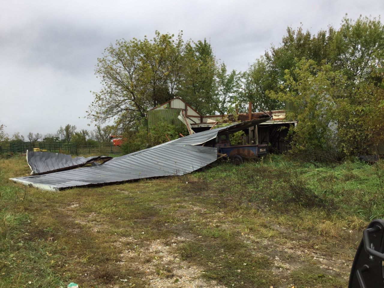
NWS photos of tornado damage in Clarke County, IA
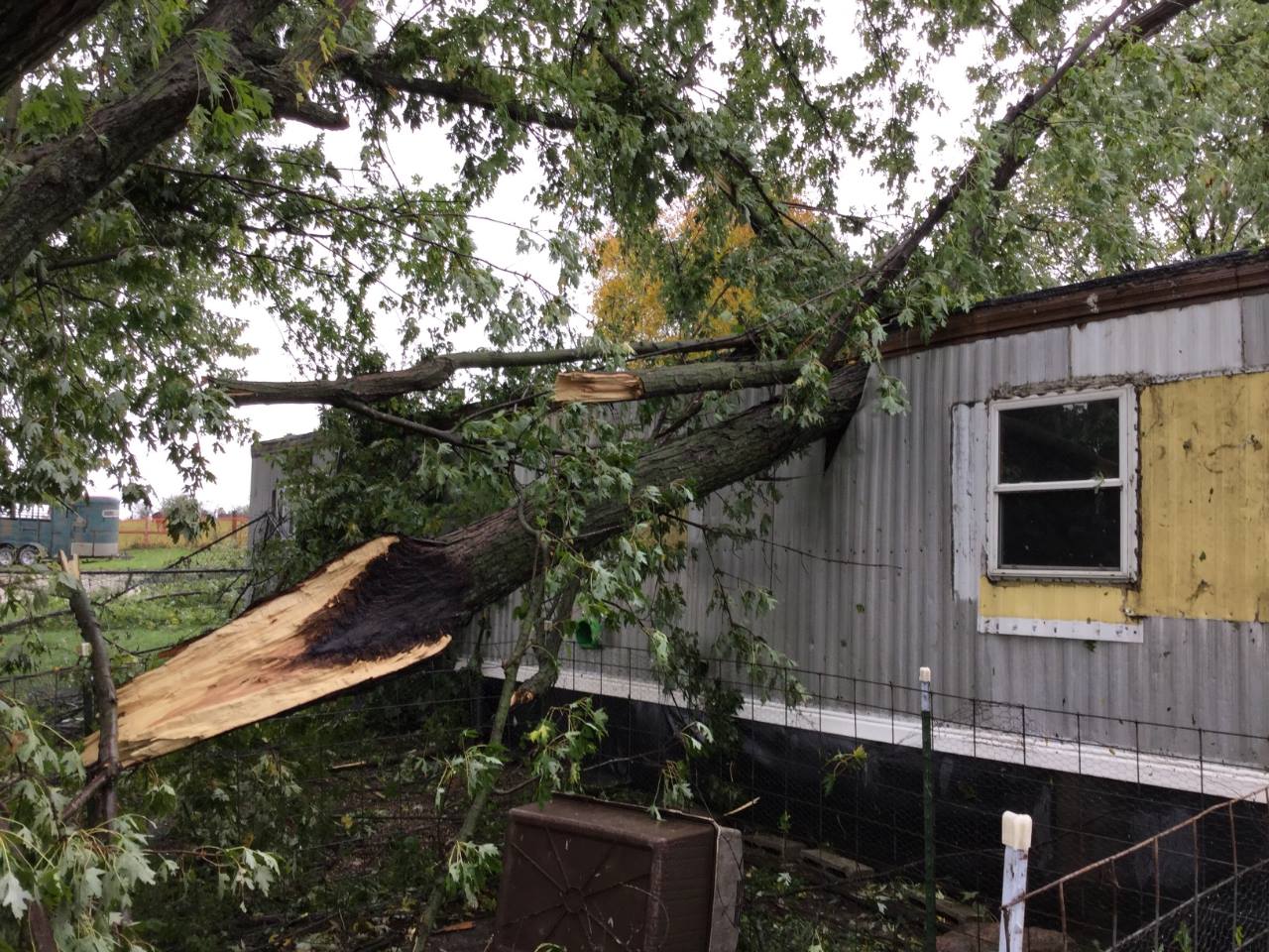 An EF-1 tornado in Clarke County packed winds estimated at 100-to 110-mph. It was generated at around 7:48-p.m. and ended at around 8:02-p.m. The twister was 250-feet wide at the height of the storm, and was on the ground for about seven-miles. The twister formed about four-miles north of Woodburn in an area of standing corn and ended seven-miles north/northeast of there. It crossed a road and caused damage to trees and later, two farmsteads. The winds were so powerful, they picked up several large feeding troughs and sent at least one hurtling one-quarter of a mile away. An abandoned outbuilding was damaged during the event, and a large tree was uprooted before it fell onto a mobile home, resulting in one injury.
Today: Cloudy to partly cloudy w/area of light rain or drizzle this morning; Temp falling into the 40’s before rebounding to around 50. NW winds 15-30mph.
Tonight: P/Cloudy. Diminishing winds. Low 34. Areas of frost possible.
Tomorrow: P/Cldy. High 50. NW @ 10-15.
Friday: Mostly cloudy w/a chance of light rain. High 45,
Saturday: P/Cldy to Cldy. High around 60.
Yesterday’s High in Atlantic was 69. Rainfall in Atlantic from 7-a.m. Monday thru 7-a.m. today was .53”. Our Low was 45. Last year on this date our High was 46 and the Low was 40. The record High in Atlantic on this date was 96 in 1893. The Record Low was 17 in 1906.
The National Weather Service cancelled the Flood Watch that was in effect until 7-a.m. today (Wednesday). Just before 4-a.m., when the Watch was cancelled, radar showed the precipitation that prompted the Watch had all but moved out of Iowa. Currently, there are no Watches or Warnings in effect for Cass and surrounding counties.
A tornado that spun-up in Union County, Tuesday evening, hop-scotched its way northward, apparently forming, dissipating and then reforming along the way. The National Weather Service in Des Moines say a tornado was spotter-confirmed on the ground five-miles west of Macksburg, near Zion, in Adair County, at around 5:42-p.m. A roof was reportedly blown off of a structure near Creston.
A twister was also observed 6-miles south of Stuart Tuesday evening, and law enforcement confirmed one touched down in a rural area near Stuart at around 6:10-p.m. A tornado was also observed on the ground in Guthrie County near Panora/Lake Panorama, according to some dispatch reports.
Other tornadoes were confirmed to have struck in Appanoose, Poweshiek, Tama and Black Hawk Counties, Tuesday. Damage was reported to have occurred at a farmstead near Cedar Falls at around 5:30-p.m., and at the Centerville Municipal Airport at around 3:21-p.m.
The Weather Service will be updating its reports as the day progresses, today (Wednesday).
The National Weather Service in Des Moines has issued a
* Tornado Warning for…
Eastern Guthrie County in west central Iowa…
Northeastern Adair County in southwestern Iowa…
Northwestern Dallas County in central Iowa…
* Until 700 PM CDT.
* At 610 PM CDT, a confirmed tornado was located over Stuart, or 14
miles northeast of Greenfield, moving north at 40 mph.
HAZARD…Damaging tornado.
SOURCE…Law enforcement confirmed tornado.
IMPACT…Flying debris will be dangerous to those caught without
shelter. Mobile homes will be damaged or destroyed.
Damage to roofs, windows, and vehicles will occur. Tree
damage is likely.
* The tornado will be near…
Guthrie Center and Panora around 630 PM CDT.
Lake Panorama around 635 PM CDT.
Other locations impacted by this tornadic thunderstorm include
Diamondhead Lake, Menlo, Linden, Yale, Jamaica, Springbrook State
Park, Lakin Slough Game Management Area and Bagley.
This includes Interstate 80 between mile markers 85 and 96.
PRECAUTIONARY/PREPAREDNESS ACTIONS…
To repeat, a tornado is on the ground. TAKE COVER NOW! Move to a
basement or an interior room on the lowest floor of a sturdy
building. Avoid windows. If you are outdoors, in a mobile home, or in
a vehicle, move to the closest substantial shelter and protect
yourself from flying debris.
Adair IA-
550 PM CDT TUE OCT 9 2018

...A TORNADO WARNING REMAINS IN EFFECT UNTIL 630 PM CDT FOR EASTERN
ADAIR COUNTY...

At 549 PM CDT, a confirmed tornado was located 7 miles east of
Greenfield, moving north at 30 mph.

HAZARD...Damaging tornado.

SOURCE...Weather spotters confirmed tornado just north of Zion or
         east northeast of Orient.

IMPACT...Flying debris will be dangerous to those caught without
         shelter. Mobile homes will be damaged or destroyed. Damage
         to roofs, windows, and vehicles will occur.  Tree damage is
         likely.

This tornado will be near...
  Stuart around 620 PM CDT.

Other locations impacted by this tornadic thunderstorm include
Greenfield Municipal Airport and Orient.

This includes Interstate 80 between mile markers 81 and 97.

PRECAUTIONARY/PREPAREDNESS ACTIONS...

To repeat, a tornado is on the ground. TAKE COVER NOW! Move to a
basement or an interior room on the lowest floor of a sturdy
building. Avoid windows. If you are outdoors, in a mobile home, or in
a vehicle, move to the closest substantial shelter and protect
yourself from flying debris.
520 PM CDT TUE OCT 9 2018

...A TORNADO WARNING REMAINS IN EFFECT UNTIL 545 PM CDT FOR
NORTHWESTERN UNION...NORTHEASTERN ADAMS AND SOUTHEASTERN ADAIR
COUNTIES...

At 520 PM CDT, a confirmed tornado was located over Green Valley
Lake, or near Creston, moving north at 35 mph.

HAZARD...Damaging tornado.

SOURCE...Emergency management confirmed tornado west of Creston.

IMPACT...Flying debris will be dangerous to those caught without
         shelter. Mobile homes will be damaged or destroyed. Damage
         to roofs, windows, and vehicles will occur.  Tree damage is
         likely.

This tornadic thunderstorm will remain over mainly rural areas of
northwestern Union...northeastern Adams and southeastern Adair
Counties, including the following locations... Nodaway Park, Orient,
Cromwell, Green Valley Lake State Park and Creston Municipal Airport.

PRECAUTIONARY/PREPAREDNESS ACTIONS...

To repeat, a tornado is on the ground. TAKE COVER NOW! Move to a
basement or an interior room on the lowest floor of a sturdy
building. Avoid windows. If you are outdoors, in a mobile home, or in
a vehicle, move to the closest substantial shelter and protect
yourself from flying debris.
Union IA-Adams IA-Adair IA-
520 PM CDT TUE OCT 9 2018

...A TORNADO WARNING REMAINS IN EFFECT UNTIL 545 PM CDT FOR
NORTHWESTERN UNION...NORTHEASTERN ADAMS AND SOUTHEASTERN ADAIR
COUNTIES...

At 520 PM CDT, a confirmed tornado was located over Green Valley
Lake, or near Creston, moving north at 35 mph.

HAZARD...Damaging tornado.

SOURCE...Emergency management confirmed tornado west of Creston.

IMPACT...Flying debris will be dangerous to those caught without
         shelter. Mobile homes will be damaged or destroyed. Damage
         to roofs, windows, and vehicles will occur.  Tree damage is
         likely.

This tornadic thunderstorm will remain over mainly rural areas of
northwestern Union...northeastern Adams and southeastern Adair
Counties, including the following locations... Nodaway Park, Orient,
Cromwell, Green Valley Lake State Park and Creston Municipal Airport.

PRECAUTIONARY/PREPAREDNESS ACTIONS...

To repeat, a tornado is on the ground. TAKE COVER NOW! Move to a
basement or an interior room on the lowest floor of a sturdy
building. Avoid windows. If you are outdoors, in a mobile home, or in
a vehicle, move to the closest substantial shelter and protect
yourself from flying debris.
TORNADO WATCH 404 IS IN EFFECT UNTIL 900 PM CDT FOR THE FOLLOWING AREA COUNTIES…
A TORNADO WATCH means that the potential exists for the development of severe thunderstorms or tornadoes, in and close to the watch area. Be prepared to seek shelter should a severe thunderstorm or tornado warning be issued.


