
…Wet Snow Expected This Afternoon and Early Evening… .An early season winter storm is bringing snow to portions of western Iowa this afternoon with the potential of 2 to 3 inches of wet snow falling into the afternoon and evening hours. This may cause a period of slick roads and potentially hazardous travel. Also, localized tree damage and power outages may occur in areas of heavier snowfall. Crawford-Carroll-Audubon-Cass-Harrison-Shelby-Pottawattamie
1245 PM CDT Sun Oct 14 2018 …WINTER WEATHER ADVISORY IN EFFECT UNTIL 7 PM CDT THIS EVENING… * WHAT…Snow accumulations of up to 2 to 3 inches with locally higher amounts are expected. * WHERE…Portions of West Central Iowa. * WHEN…Until 7 PM CDT this evening. * ADDITIONAL DETAILS…Plan on slippery road conditions. Expect reduced visibilities at times. Localized tree damage and power outages may occur in areas of heavier snowfall accumulation. PRECAUTIONARY/PREPAREDNESS ACTIONS… A Winter Weather Advisory means that periods of snow, sleet or freezing rain will cause travel difficulties. Expect slippery roads and limited visibilities, and use caution while driving. The latest road conditions for the state you are calling from can be obtained by calling 5 1 1.
Today: Cloudy and breezy with rain likely before noon, then a rain/snow mix. Temperature falling to around 35 by 1pm. North wind 15 to 20 mph, with gusts to near 30. New snow accumulation of less than one inch possible.
Tonight: A 30% chance of snow, mainly before 9pm. Skies clearing overnight. FREEZE WARNING 1-a.m. Monday thru 10-a.m. Widespead frost after 4am. Low around 26. NW @ 5-10. New snow accumulation of less than a half inch possible.
Monday: Widespread frost before 9am. Otherwise, sunny, with a high near 42. NW wind 5-10mph.
Monday Night: Clear, with a low around 29. Southwest wind 5 to 10 mph.
Tuesday: Sunny, with a high near 55.
Tuesday Night: Clear, with a low around 35.
Wednesday: Sunny, with a high near 55.
Yesterday’s High in Atlantic was 60. Our Low this morning, 41. We received .01″ rain overnight. Last year on this date, the High in Atlantic was 64 and the Low was 44. The All-time Record High in Atlantic on Oct. 14th was 88 in 1897. The Record Low was 16 in 1937.
Area Counties affected: Sac-Crawford-Carroll-Audubon-Guthrie-Dallas-Cass-Adair-Madison-Adams- Union-Taylor-Ringgold-Monona-Harrison-Shelby-Pottawattamie-Mills-Montgomery-Fremont and Page….
FREEZE WARNING IN EFFECT FROM 1 AM TO 10 AM CDT MONDAY… The National Weather Service in Des Moines has issued a Freeze Warning, which is in effect from 1 AM to 10 AM CDT Monday.
TEMPERATURE…Mid 20s to around 30.
* IMPACTS…The below freezing temperatures will result in a killing freeze and end the growing season for central Iowa.
PRECAUTIONARY/PREPAREDNESS ACTIONS… A Freeze Warning means sub-freezing temperatures are imminent or highly likely. These conditions will kill crops and other sensitive vegetation.
Skyscan Forecast Saturday, October 13, 2018 Dan Hicks
Today: Areas of fog and low clouds will give way to partly cloudy skies. SW @ 10-20. High 60.
Tonight: Mostly cloudy. Light rain late. NW @ 10-20. Low 37.
Sunday: Cloudy. Windy and cooler. Light rain and mixed with light snow possibly in the morning. NW 15-30. High 42.
Sunday Night: Cloudy. Chance of rain showers possibly mixed with light snow. Widespread frost. NNW @ 10. L 28.
Monday: Partly cloudy. High 48.
Tuesday: Partly cloudy. High 58.

Podcast: Play in new window | Download (754.1KB)
Subscribe: RSS
(Radio Iowa) — Snow fell in parts of Iowa this (Friday) morning, but for the Iowa DOT, their activities begin to ramp-up in a few days. The Iowa Department of Transportation’s Winter Operations Administrator Craig Bargfrede says their winter season begins Monday. “In our world, winter officially starts on October 15th and runs until the 15th of April,” Bargfrede said. The DOT has implemented a couple of changes as workers prepare for another winter of battling snow and ice on the state’s roads. Bargfrede says cameras will be installed in ALL snow plows and still images will be posted online. “So, the public will be able to view those and see what’s actually going on out on the system from our operator’s perspective,” Bargfrede said.
Last winter, about two-thirds of the DOT’s roughly 900 snow plows had cameras. This year, all of them will be equipped with the technology. All plows will also feature blue and white safety lights, along with the familiar amber color. “The blue and white portion of our lighting package is only rear facing. So, you will know when you see that lighting package, you’ll be coming up (behind) a snow plow truck,” Bargfrede said. The Iowa DOT experimented with the blue and white colors for the past several years and, according to Bargfrede, they’ve helped reduce certain types of crashes by nearly two-thirds. “Our own internal research crash data over the last four years, we really saw a reduction in rear-end and side-swipe crashes to our vehicles when we started doing the blue-white-amber lighting package,” Bargfrede said.
The Iowa DOT sets aside $40 million each year for winter operations. Bargfrede oversees roughly 1,000 full-time employees. “And we’re also in the process of trying to hire some seasonal employees, in the neighborhood of 600 seasonal employees, to augment our full-time staff across the state of Iowa,” Bargfrede said. Those part-timers are paid $17.45 an hour. Iowa’s low unemployment rate is making it difficult to find those extra workers, according to Bargfrede. While DOT workers wait for the first significant winter storm, they’re busy with maintenance on the plow trucks, topping off storage sheds with salt, and going through driver training. “We have a driving simulator that is rotating throughout our districts, where we’ve got operators going through and doing refresher training and new operator training on that driving simulator,” Bargfrede said.
Today: Cloudy w/occasional light rain. High 44. Winds variable @ 5-10mph.
Tonight: Cloudy to partly cloudy w/areas of fog and light frost. Low 33. SE @ 5-10.
Tomorrow: Areas of morning fog; P/Cldy & warmer. High around 60. SW @ 10-20.
Sunday: Mo. Cldy w/areas of light rain. High 46.
Monday: P/Cldy. High near 50.
Yesterday’s High in Atlantic was 49. Our Low this morning 35. Rainfall overnight thru 6-a.m today amounted to .06″. Last year on this date our High was 66 and the Low was 48. The record High in Atlantic on this date was 90 in 1899. The Record Low was 17 in 1908.
Gov. Kim Reynolds issued a disaster proclamation today (Thursday) for 19 counties, in response to severe weather, including damaging winds, heavy rains, flooding and tornadoes, that took place beginning October 4, 2018. In southwest Iowa, Union County is included in the proclamation, which allows state resources to be utilized to respond to and recover from the effects of this severe weather and activates the Iowa Individual Assistance Grant Program for qualifying residents, along with the Disaster Case Management Program.
The Iowa Individual Assistance Grant Program provides grants of up to $5,000 for households with incomes up to 200 percent of the federal poverty level or a maximum annual income of $41,560 for a family of three. Grants are available for home or car repairs, replacement of clothing or food and temporary housing expenses. Original receipts are required for those seeking reimbursement for actual expenses related to storm recovery. The grant application and instructions are available on the Iowa Department of Human Services website. Potential applicants have 45 days from the date of the proclamation to submit a claim.
Disaster Case Management is a program to address serious needs to overcome a disaster-related hardship, injury or adverse condition. Disaster case managers work with clients to create a disaster recovery plan and provide guidance, advice and referral to obtain a service or resource. There are no income eligibility requirements for this program; it closes 180 days from the date of the governor’s proclamation. For information on the Disaster Case Management Program, contact your local community action association or visit www.iowacommunityaction.org.
Iowans impacted by severe weather are asked to report damage to help local and state officials better understand the damage sustained. Damage to property, roads, utilities and other storm-related information may be reported. This information will be collected by the Iowa Department of Homeland Security and Emergency Management and shared with local emergency management agencies.
Today: Partly cloudy. High around 48. NW winds 15-25mph diminishing late.
Tonight: Clear to P/Cloudy. Low 33. Winds light & variable.
Tomorrow: Mostly cloudy w/scattered light rain. High 44. E @ 5-10.
Saturday: P/Cldy. High around 60.
Sunday: P/Cldy to Cldy. High around 48.
Yesterday’s High in Atlantic was 49. Rainfall in Atlantic Wednesday (after 7-a.m.) amounted to .01” Our Low this morning (as of 5-a.m.) was 37. Last year on this date our High was 66 and the Low was 41. The record High in Atlantic on this date was 93 in 1893. The Record Low was 17 in 1987.
Officials with the National Weather Service today (Wednesday), confirmed a weak tornado with wind speeds estimated at 70-miles per hour, caused damage to standing corn, but no structural damage. In their preliminary assessment, officials said the twister was rated an EF-0, which typically have winds of 65-to 85-mph. The Guthrie County twister started at around 6:20-p.m. Tuesday about four-miles southwest of Jamaica, and ended one-half mile south of Jamaica about 12 minutes later. It was four miles long and 80-feet wide. It tracked northeastward through primarily cropland, causing tracks where it flattened the corn in a distinct path.
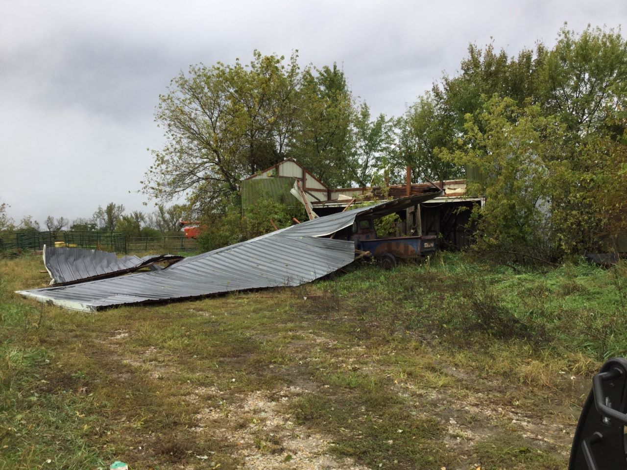
NWS photos of tornado damage in Clarke County, IA
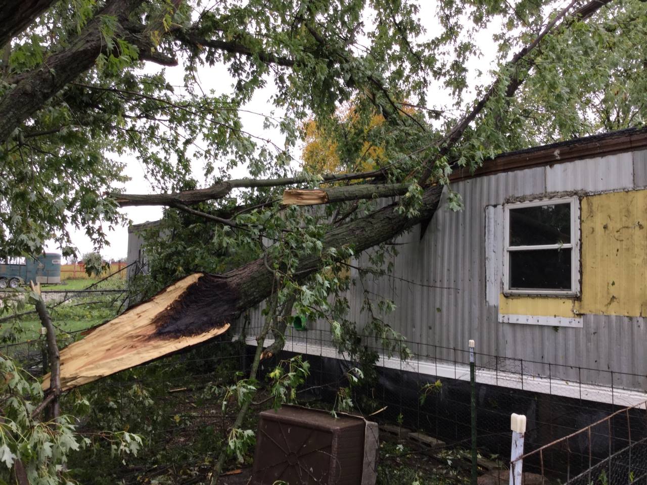 An EF-1 tornado in Clarke County packed winds estimated at 100-to 110-mph. It was generated at around 7:48-p.m. and ended at around 8:02-p.m. The twister was 250-feet wide at the height of the storm, and was on the ground for about seven-miles. The twister formed about four-miles north of Woodburn in an area of standing corn and ended seven-miles north/northeast of there. It crossed a road and caused damage to trees and later, two farmsteads. The winds were so powerful, they picked up several large feeding troughs and sent at least one hurtling one-quarter of a mile away. An abandoned outbuilding was damaged during the event, and a large tree was uprooted before it fell onto a mobile home, resulting in one injury.


