
Today (Christmas Day): Partly sunny, with a high near 43. Light south southeast wind.
Tonight: Cloudy, with a low around 31. East wind 5 to 10 mph.
Wednesday: A slight chance of sleet before 7am, then a chance of freezing rain and sleet between 7am and 9am, then rain after 9am. High near 42. Breezy, with an east southeast wind 10 to 15 mph, with gusts as high as 25 mph. Chance of precipitation is 90%. Little or no ice accumulation expected. Little or no sleet accumulation expected.
Wednesday Night: Rain. Temperature rising to around 47 by 5am. Breezy, with a southeast wind around 17 mph, with gusts as high as 28 mph. Chance of precipitation is 90%. New precipitation amounts between three quarters and one inch possible.
Thursday: Rain, mainly before noon. High near 50. Breezy, with a southeast wind 15 to 25 mph becoming west in the afternoon. Chance of precipitation is 80%. New precipitation amounts between a quarter and half of an inch possible.
Thursday Night: A chance of rain and snow before 9pm, then a chance of snow and freezing rain between 9pm and midnight. Mostly cloudy, with a low around 24. Blustery. Chance of precipitation is 30%.
Friday: Cloudy, with a high near 26. Blustery.
Yesterday’s High in Atlantic was 42. Our 24-hour Low (ending at 7-a.m. Today) will be/was 19 Last year on this date our High was 13 and the Low was -7. The record High in Atlantic on this date was 56 in 1922. The Record Low was -20 in 1983.
A winter storm will impact the region from mid-week into late this week with the best chance of accumulating snow over northwest Iowa. While the precipitation may start as a wintry mix on Wednesday, warmer air will arrive over the state changing the precipitation to mainly rain from Wednesday night through late Thursday. Colder air will surge into the state Thursday night into Friday causing the rain to change to light snow before ending. Gusty winds will also develop and accentuate the chill. Those with travel plans across the region later this week should check the forecast for the latest information. 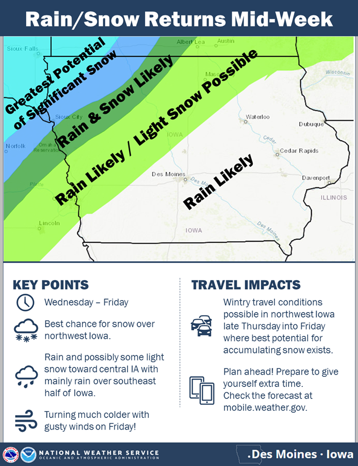
Today (Christmas Eve): Areas of fog this morning; Partly cloudy. High around 40. SE @ 10.
Tonight: Mostly cloudy w/light rain or flurries. Low 28 20. SE @ 5. W
Christmas Day: Mostly cloudy w/light snow or flurries. High near 40. SE @ 10-15.
Wednesday: Cldy w/rain becoming mixed with snow. High near 39. Thursday: Mo Cldy w/rain. High 44.
Yesterday’s High in Atlantic was 41. Our Low this morning was 18 Last year on this date our High was 22 and the Low was 1. The record High in Atlantic on this date was 55 in 1893 & 1964. The Record Low was -23 in 1983.
Today: Sunny & breezy, with a high near 39. W @ 5-15mph w/gusts to near 25.
Tonight: Mostly clear, with a low around 20. West wind around 6 mph becoming calm.
Monday: Partly sunny, with a high near 41. Southeast wind 5 to 10 mph.
Monday Night: A chance of rain and snow before 11pm, then a chance of snow. Cloudy, with a low around 30. South southeast wind 5 to 8 mph. Chance of precipitation is 40%. New snow accumulation of less than a half inch possible.
Christmas Day: Mostly cloudy, with a high near 40. Light and variable wind becoming north around 5 mph in the afternoon.
Tuesday Night: Mostly cloudy, with a low around 28.
Wednesday: Rain after noon. High near 39. Breezy. Chance of precipitation is 80%.
Yesterday’s High in Atlantic was 41. Our Low this morning was 25 Last year on this date our High was 25 and the Low was 15. The record High in Atlantic on this date was 62 in 1964. The Record Low was -22 in 1983.
Today: Partly cloudy. High 42. Winds NW this morning becoming SE @ 5-10.
Tonight: P/Cldy. Low 25. S @ 5-10.
Tomorrow: Mostly cloudy. High 41. Winds variable @ 5-10.
Sunday: Mo. Cldy. High 41.
Monday (Christmas Eve): Mo. Cldy. High 43.
Yesterday’s High in Atlantic was 37. Our Low this morning was 28. Last year on this date our High was 39 and the Low was 20. The record High in Atlantic on this date was 58 in 1941. The Record Low was -22 in 1989.
Today: Partly cloudy. High around 40. NW winds 15-25 mph.
Tonight: Mostly clear w/diminishing winds. Low 20.
Tomorrow: P/Cldy. High 44. SE @ 10-15.
Saturday: Mostly cloudy. High 43.
Sunday: Mo. Cldy. High 41.
Yesterday’s High in Atlantic was 50. Our Low was 34. We received a trace of rain Wednesday night. Last year on this date our High was 47 and the Low was 16. The record High in Atlantic on this date was 61 in 1941. The Record Low was -25 in 1901.
Today: Mostly cloudy w/scattered light rain showers. High 47. S-NW @ 10-15 mph.
Tonight: Mo. Cldy w/rain ending. Low 31. NW @ 10-15.
Tomorrow: Partly sunny. High 39. NW late @ 15-25.
Friday: P/Cldy. High 45.
Saturday: Mo. Cldy. High 43.
Yesterday’s High in Atlantic was 52. We received a trace of rain overnight into early this morning. Our Low was 35. Last year on this date our High was 49 and the Low was 16. The record High in Atlantic on this date was 58 in 1966. The Record Low was -33 in 1983.
Today: Partly cloudy & mild. High 52. SW @ 10-20 mph.
Tonight: P/Cldy. Low 36. S @ 5-10.
Tomorrow: Mostly cloudy w/light rain. High 47/ S winds becoming NW late @ 10-15.
Thursday: A chance of morning flurries; P/Cldy. High 40.
Friday: P/Cldy. High 45.
Yesterday’s High in Atlantic was 46. Our 24-hour Low (ending at 7-a.m.) was 18. Last year on this date our High was 51 and the Low was 26. The record High in Atlantic on this date was 66 in 1976. The Record Low was -28 in 1983.
Today: Areas of fog this morning; Becoming partly cloudy. High 49. S @ 5-10.
Tonight: Fair to P/Cldy/ Low 25. S @ 5.
Tomorrow: P/Cldy. High 52. S @ 10-15.
Wednesday: P/Cldy to cloudy w/light rain during the afternoon. High 45.
Thursday: A chance of light rain or flurries early; P/Cldy. High near 40.
Yesterday’s High in Atlantic was 44. Our Low this morning (as of 6-a.m.) was 18. Last year on this date our High was 41 and the Low was 18. The record High in Atlantic on this date was 65 in 1939. The Record Low was -18 in 1951.
Today: Sunny, with a high near 41. Northwest wind 5 to 10 mph.
Tonight: Mostly clear, with a low around 17.
Monday: Sunny, with a high near 43. Winds becoming southerly at 5 to 10 mph in the afternoon.
Monday Night: Mostly clear, with a low around 27.
Tuesday: Mostly sunny, with a high near 45. S/SW @ 10.
Tuesday Night: Mostly cloudy, with a low around 31.
Wednesday: Mostly cloudy, with a high near 43.
Wednesday Night: Mostly cloudy, with a low around 30.
Thursday: Partly sunny & breezy, with a high near 39.
Saturday’s High in Atlantic was 44. Our 24-hour ending at 7-a.m. today, will be 14 (at 6-a.m it was 20 degrees). Last year on this date, the High in Atlantic was 55 and the Low was 27. The record High here on this date was 59 in 1962, and the record Low was -22 in 1951.


