
Today: A 40 percent chance of snow between 1pm and 5pm. Cloudy, with a temperature falling to around 16 by 5pm. Wind chill values as low as zero. Blustery, with a northwest wind 16 to 20 mph, with gusts as high as 31 mph. Little or no snow accumulation expected.
Tonight: Mostly cloudy, with a low around 6. Wind chill values as low as -5. Blustery, with a north northwest wind 7 to 16 mph, with gusts as high as 25 mph.
Saturday: Sunny, with a high near 23. Wind chill values as low as -5. Light and variable wind becoming southwest 5 to 9 mph in the morning.
Saturday Night: Clear, with a low around 17. South southwest wind 7 to 13 mph, with gusts as high as 21 mph.
Sunday: Sunny, with a high near 39. Breezy.
Sunday Night: A chance of snow and freezing rain between midnight and 1am, then a chance of snow after 1am. Partly cloudy, with a low around 25. Chance of precipitation is 30%.
Monday: A slight chance of snow and freezing rain before 10am, then a slight chance of snow between 10am and noon. Mostly cloudy, with a high near 31. Blustery. Chance of precipitation is 20%.
Yesterday’s High in Atlantic was 54. Our Low tis morning (as of 6-a.m.) was 19. We received .1” rain yesterday, and freezing drizzle this morning, making roads 100% ice covered. Last year on this date our High was 19 and the Low was 3. The record High in Atlantic on this date was 65 in 1984. The Record Low was -25 in 1924.
Heavy snowfall and blizzardlike conditions are being reported as a powerful winter storm moves through the middle of Nebraska. The Nebraska Transportation Department closed Interstate 80 and U.S. Highway 30 in both directions Thursday morning, from Lexington to North Platte. It cited whiteout and other weather factors. The National Weather Service has posted blizzard or winter storm warnings for several counties. Most of the warnings are scheduled to expire by Friday morning. Six inches of snow was reported in Cozad and Elwood.
Today: Cloudy w/rain this morning; Light rain or drizzle this afternoon. High this morning of 52 w/temps nearly steady or slowly falling this afternoon. S winds becoming NW @ 15-25.
Tonight: Cloudy w/light rain, light snow or flurries. Low 24. NW @ 15-25.
Tomorrow: Mostly cloudy, windy & colder w/light snow or flurries. High 25. NW @ 15-30.
Saturday: Partly cloudy. High 27.
Sunday: P/Cldy. High 31.
Yesterday’s High in Atlantic was 46. Our Low was 33. We received .45” rain yesterday and overnight into this morning at the KJAN studios. Last year on this date our High was 8 and the Low was -16. The record High in Atlantic on this date was 65 in 1946. The Record Low was -21 in 1924.
OMAHA, Neb. (AP) — Forecasters say a powerful winter storm is headed into western and northern Nebraska, carrying the potential to dump more than a foot of snow in some spots. The National Weather Service says a wintry mix was falling Wednesday morning on the west end of the state. It’s expected to change to rain as temperatures rise but turn to snow as temperatures fall Wednesday night.
The service warns that post-Christmas road travel conditions could run from difficult to impossible overnight into Thursday evening, thanks to snow whipped up by wind gusts of 40 mph or more. The heaviest snow is expected to fall from Valentine to Ainsworth in north-central Nebraska, extending southwest to North Platte. Rain is expected in Lincoln, Omaha and other population centers in eastern and southeastern Nebraska.
The National Weather Service in Johnston says it’s going to be quite wet across Iowa over the next 24 to 48 hours. Precip may initially begin as period of snow in northern Iowa where temperatures remain near freezing. This may lead to some hazardous driving conditions. Any snowfall will change to rain as temperatures warm this evening. Total rainfall of an inch or more is likely with the majority of that falling this evening through early Thursday. A few rumbles of thunder are also possible Thursday! Expect much colder and blustery conditions Friday along with lingering chances for some light freezing rain or snow, mainly in northern Iowa.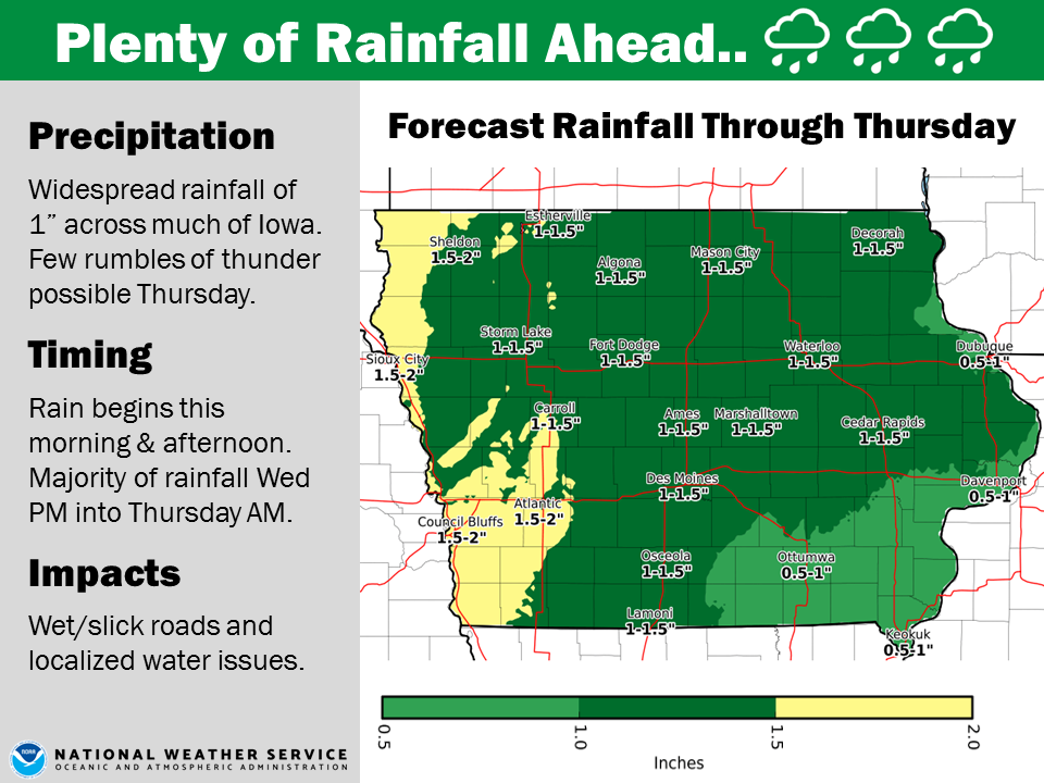
Sac-Crawford-Carroll-Audubon-Guthrie-Dallas-Cass-Adair-Madison-Adams-Union-Taylor and Ringgold Counties…
DAY ONE…Today and tonight: A strong storm system moves through the region today and into tonight. Widespread rainfall will occur over much of Iowa, mainly from this afternoon through tonight. Rainfall amounts of over an inch may result in ponding of water and possibly isolated minor river flooding.
DAYS TWO THROUGH SEVEN…Thursday through Tuesday: A few thunderstorms are possible late Thursday afternoon and evening. Cold and blustery conditions will result in falling temperatures Friday along with a chance for light freezing rain or light snow north of Interstate 80. Minor travel impacts are possible.
Monona-Harrison-Shelby-Pottawattamie-Mills-Montgomery-Fremont-Page Counties…
DAY ONE…Today and Tonight: A mixture of light snow, sleet, and freezing rain is possible this morning, mainly over portions of northeast NE. A few thunderstorms are possible late tonight over portions of southeast NE.
DAYS TWO THROUGH SEVEN…Thursday through Tuesday: A few thunderstorms remain possible through at least Thursday morning. Locally heavy rainfall is possible, potentially pushing some area streams and rivers to bankfull. Rain will mix with snow or light freezing rain on Thursday afternoon over portions of northeast NE with the rain-snow transition shifting southeast across the remainder of the area into Thursday night. Snowfall accumulations should generally remain an inch or less.
Today: Light drizzle or freezing drizzle possible this morning; Cloudy. High around 40. SE @ 15-25.
Tonight: Cldy w/rain. Temps rising into the 40’s overnight. S @ 15-25.
Tomorrow: Cldy w/rain in the morning, drizzle in the afternoon. High 52. S @ 15-25.
Friday: Mostly cloudy w/light snow or flurries. High 26.
Saturday: P/Cldy. High around 26.
Yesterday’s High in Atlantic was 46. Our Low this morning 26. Last year on this date our High was 8 and the Low was -16. The record High in Atlantic on this date was 59 in 1936. The Record Low was -18 in 1892.
(Radio Iowa) — A new climate assessment for Iowa and the rest of the Northern Plains predicts the region will see overall warmer temperatures and more “rain extremes” in the months and years ahead. Meteorologist Dennis Todey, director of the U-S-D-A’s Midwest Climate Hub, based in Ames, says ag producers will need to make more and more adjustments, starting with soil health. “At worst, maintain. Don’t lose any more of your soil, but do things that help regenerate that soil with reducing tillage when you’re harvesting a crop,” Todey says. “Don’t remove some of that stover as much as possible to help renew the soil and help keep regenerating the soil.”
While concerns have been raised for years over nutrient application on fields and the subsequent run-off, Todey says fertilizer use will have to be even more carefully monitored. “Being more judicious with our nutrient application so we don’t get any kind of water quality issues,” Todey says. In some areas of the region, he says agricultural producers may have to consider changing the crops they plant to align better with the changing climate. “Corn and soybeans are things that people know how to grow,” Todey says. “They’re insured. There’s a number of issues supporting that, but, especially when we have the pricing issues right now, are there other things you can grow, that you know how to grow, that are more able to be managed under the conditions we’re dealing with?”
The national climate assessment report endeavors to forecast approaching changes over the next 10-to-30 years.
Today (Christmas Day): Partly sunny, with a high near 43. Light south southeast wind.
Tonight: Cloudy, with a low around 31. East wind 5 to 10 mph.
Wednesday: A slight chance of sleet before 7am, then a chance of freezing rain and sleet between 7am and 9am, then rain after 9am. High near 42. Breezy, with an east southeast wind 10 to 15 mph, with gusts as high as 25 mph. Chance of precipitation is 90%. Little or no ice accumulation expected. Little or no sleet accumulation expected.
Wednesday Night: Rain. Temperature rising to around 47 by 5am. Breezy, with a southeast wind around 17 mph, with gusts as high as 28 mph. Chance of precipitation is 90%. New precipitation amounts between three quarters and one inch possible.
Thursday: Rain, mainly before noon. High near 50. Breezy, with a southeast wind 15 to 25 mph becoming west in the afternoon. Chance of precipitation is 80%. New precipitation amounts between a quarter and half of an inch possible.
Thursday Night: A chance of rain and snow before 9pm, then a chance of snow and freezing rain between 9pm and midnight. Mostly cloudy, with a low around 24. Blustery. Chance of precipitation is 30%.
Friday: Cloudy, with a high near 26. Blustery.
Yesterday’s High in Atlantic was 42. Our 24-hour Low (ending at 7-a.m. Today) will be/was 19 Last year on this date our High was 13 and the Low was -7. The record High in Atlantic on this date was 56 in 1922. The Record Low was -20 in 1983.


