
Today: Mostly cloudy. High 30. N @ 5-10.
Tonight: Mo. Cldy w/ light snow developing late. Low 24. E @ 5-10.
Tomorrow: Mo. Cldy w/light snow in the morning (<1″). High 32. N @ 10.
Friday: Cldy w/snow, especially in the afternoon. High 28.
Saturday: Mo. Cloudy, windy and cold w/light snow in the morning. High 12.
Yesterday’s High in Atlantic was 33. We received freezing drizzle yesterday, amounting to a little more than a trace of precip. Our Low this morning was 19. Last year on this date our High was 7 and the Low was -9. The record High in Atlantic on this date was 64 in 1990. The Record Low was -25 in 2009.
The Iowa Dept. of Transportation reports numerous area highways are partially covered with ice this morning, creating slick driving surfaces, especially on bridges. Some affected roads include:
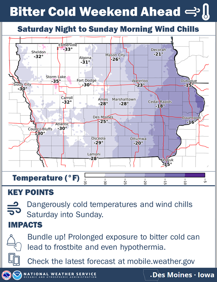
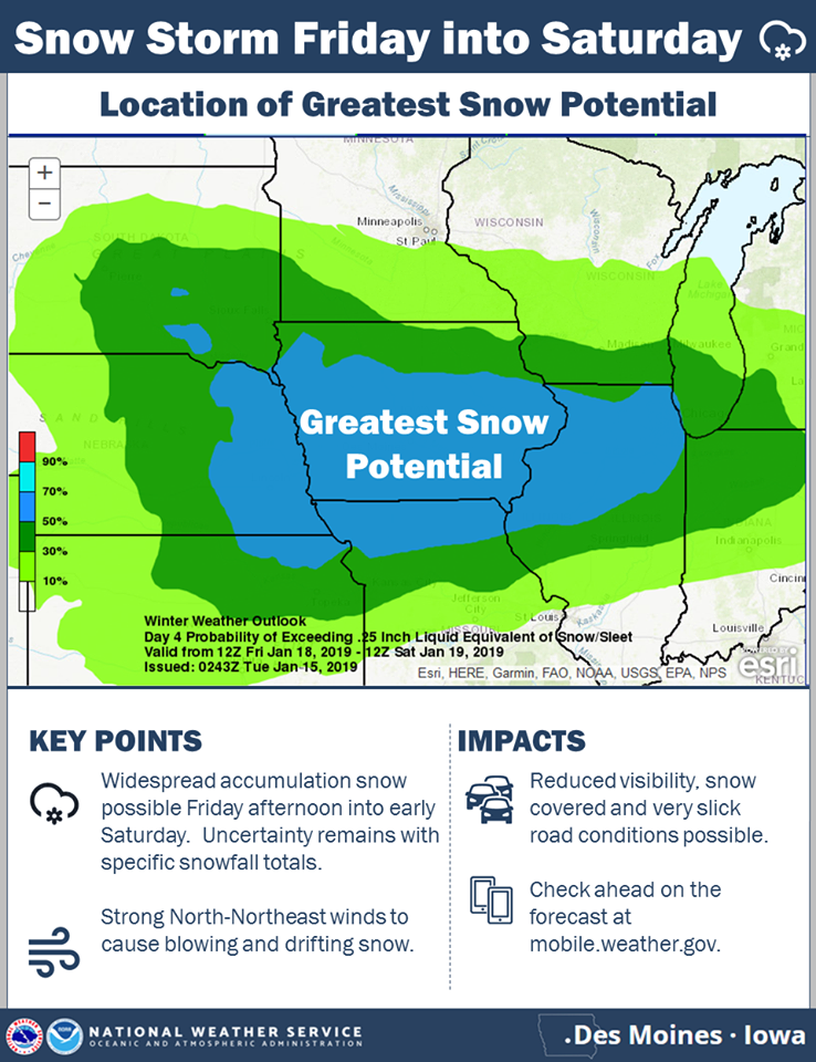
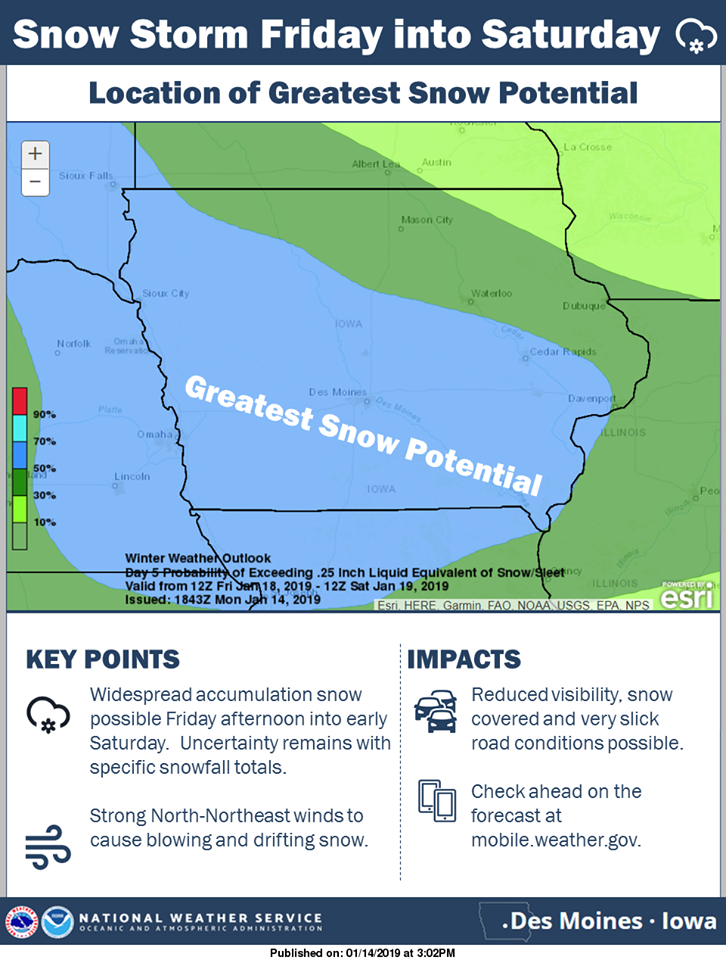
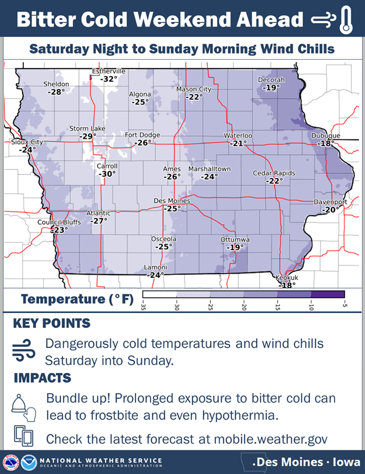
The National Weather Service reports several weather impacts are coming in the days ahead, across Iowa…The first one is a light dusting of snow possible Wednesday night into early Thursday. This could cause some slick spots during the Thursday morning commute. The second one is a larger storm system taking aim at the region for later Friday into Saturday. This system will likely spread snow and blowing snow across much of the area. Travel impacts are anticipated by Friday afternoon into Saturday. Lastly, bitter cold arctic air will surge into the state Saturday and remain into early next week. Wind chills will drop into the teens below to around 35 below zero by Sunday morning. (Click on the graphics to enlarge>>>)
Today: Areas of fog & patchy freezing drizzle this morning; Partly cloudy to cloudy. High 38. SW @ 10-20.
Tonight: P/Cldy to Cldy. Low 20. N @ 10-15.
Tomorrow: P/Cldy to Cldy. High 32. NE @ 10-15.
Thursday: Mostly cloudy w/a chance of light snow. High 32.
Friday: Cloudy w/snow, especially during the afternoon. High 28.
The National Weather Service today (Monday) said a widespread snow event is forecast for much of Friday into early Saturday across the state. There remains some uncertainty with respect to actual snowfall totals, but confidence is increasing in the timing and location of the snow event. In addition the widespread snow, blustery north to northeast winds are expected and will likely cause significant visibility restrictions along with blowing and drifting snow Friday afternoon into Saturday.
Then, an Arctic blast of bitter cold temperatures and wind chills filter into the state over the weekend. Sub-zero wind chills are anticipated for much of the weekend, with many locations dipping as low as 20 to 35 below zero by Saturday night into Sunday morning.
Today: Isolated areas of dense fog this morning, otherwise partly cloudy to cloudy. High 34. SW @ 10-15 mph.
Tonight: P/cldy to cldy w/areas of dense fog developing late. Low 20. SW @ 5-10.
Tomorrow: Areas of fog in the morning; P/Cldy to Cldy. High around 40. W @ 10-15.
Wednesday: P/Cldy. High 32.
Thursday: Mo. cldy w/scattered flurries. High 35.
Yesterday’s High in Atlantic was 37. We received a trace of snow at the KJAN studios overnight. Our Low was 8. Last year on this date our High was 28 and the Low was 1. The record High in Atlantic on this date was 54 in 1914. The Record Low was -29 in 1957.
Today: Patchy fog between 8am and 10am. Otherwise, mostly cloudy, with a high near 30. North northeast wind around 6 mph becoming calm in the morning.
Tonight: Mostly cloudy, with a low around 19. Wind chill values as low as 10. Light south southwest wind becoming southwest 5 to 9 mph in the evening.
Monday: Partly sunny, with a high near 34. Wind chill values as low as 10. Southwest wind 9 to 11 mph.
Monday Night: Mostly cloudy, with a low around 23. Southwest wind around 7 mph.
Tuesday: Mostly sunny, with a high near 37. Southwest wind 6 to 10 mph.
Tuesday Night: Mostly clear, with a low around 18.
Wednesday: Mostly sunny, with a high near 27.
Yesterday’s High in Atlantic was 31. We received .8” of snow after 7-a.m., which melted into .06” liquid precipitation. (Storm total 4.4” snow). Our Low this morning was 27. Last year on this date our High was 14 and the Low was 6. The record High in Atlantic on this date was 62 in 1987. The Record Low was -24 in 1916.
DES MOINES — Officials with the Iowa Dept. of Natural Resources said Friday, that Iowa received 45 inches of rainfall – nearly 10 inches more than normal, in 2018. That puts 2018 second only to 1993 for average statewide precipitation, according to the year-end Water Summary Update. While there was some dryness in the southwestern portion of the state, 27 northern Iowa counties marked their wettest year on record. Streamflow was above normal for most of the year, while shallow groundwater levels recovered from low levels in southern Iowa to become normal to above normal for the entire state.
Tim Hall, DNR’s coordinator of hydrology resources, said in the report, “The concerns about dryness and drought in southeastern Iowa were ended with the wet summer and fall, and the entire state is in pretty good shape for groundwater going into the normally dry months of winter.” Temperatures were typical of Iowa weather in 2018 – all over the map. April was the coldest on record. May was the third warmest, and this June was the 10th warmest. November was 6.4 degrees below average and December was 5.1 degrees above average.
For a thorough review of Iowa’s water resource trends, go to www.iowadnr.gov/watersummaryupdate. The report is prepared by technical staff from Iowa DNR, the Iowa Department of Agriculture and Land Stewardship, IIHR—Hydroscience and Engineering, and the U.S. Geological Survey, in collaboration with Iowa Homeland Security and Emergency Management Department.
**Winter Weather Advisories in effect – see a separate post on the kjan.com Weather page***
Today: Cloudy, w/snow this morning (2-3” additional snow today), flurries this afternoon. High 32. N/NE @ 10-20.
Tonight: Mostly cloudy w/flurries ending. Low 20. N @ 10-20.
Tomorrow: Mostly cloudy. High 34. N @ 10.
Monday: Partly cloudy. High 37.
Tuesday: P/Cldy. High 40.
Yesterday’s High in Atlantic was 37. Our Low this morning 29. As of 6-a.m., we had received 3.5” of snow at the KJAN studios. Last year on this date our High was 10 and the Low was -4. The record High in Atlantic on this date was 57 in 1961 & 1987. The Record Low was -37 in 1974.
**WINTER WEATHER ADVISORY for snow in effect from 6-p.m. today until 6-p.m. Saturday**
Today: Cloudy. High 37. SE @ 10-15 mph.
Tonight: Cloudy w/a light rain/snow mix becoming all snow. (2-4″ possible in the Atlantic area). Low 27. E @ 10-15.
Tomorrow: Cloudy w/light snow in the morning; flurries in the afternoon. High 32. NE @ 10-20.
Sunday: Mostly cloudy. High 34.
Monday: Partly cloudy. High 37.


