
DAVENPORT, Iowa (AP) — Several schools, businesses and agencies are remaining closed as Iowa’s record-breaking and dangerous deep freeze continues. The National Weather Service has posted wind chill advisories or warnings for Iowa, but they’re expected to expire later this (Thursday) morning. The bitter cold that beset the nation’s midsection broke records in several Iowa cities Wednesday, including Des Moines. The minus 20 handily broke the 1965 low of minus 17. The Wednesday wind child hit minus 40.
The minus 25 degrees in Waterloo broke the Jan. 30 record of minus 24 set in 1951. Estherville, Lamoni, Mason City and Ottumwa also had record low temperatures. Here in southwest Iowa, many schools are running two-hours late this morning, due to the chilly weather.
Today: **Wind Chill Advisory until 10-a.m.** Cloudy w/a 20% chance of light snow or flurries. High 15. SE @ 10-15 mph.
Tonight: Partly cloudy to cloudy. Low 10. SE @ 5-10.
Tomorrow: P/Cldy to Cldy. High 34. SE @ 10-20.
Saturday: P/Cldy to Cldy. High 43.
Sunday: P/Cldy to Cldy. High 47.
Yesterday’s High in Atlantic was -3. Our Low was -19. We received a trace of snow early this morning in Atlantic (through 5:25-a.m.). Last year on this date our High was 39 and the Low was 10. The record High in Atlantic on this date was 59 in 2012. The Record Low was -28 in 1996.
Today: **Wind Chill Warning in effect until 6-p.m. today** Partly cloudy. High -3. NW @ 10-15. Wind chill values as low as -40.
Tonight: **Wind Chill Advisory from 6-p.m. today until 9-a.m. Thursday**.Mostly cloudy w/a chance of flurries. Low -10, w/near steady-to-slowly rising temps overnight to around -2. SE @ 5-10. Wind chill values as low as -20.
Tomorrow: Mo. Cldy w/a chance of light snow or flurries. High 15. SE @ 10-15. Wind chill values as low as -20.
Friday: P/Cldy to Cldy. High around 32.
Saturday: P/Cldy to Cldy. High 42.
Yesterday’s High in Atlantic was 6. Our Low this morning was -19. Last year on this date our High was 43 and the Low was 22. The record High in Atlantic on this date was 65 in 2012. The Record Low was -24 in 1965.
The National Weather Service says the second push of Arctic air is well under way with northwest winds once again pushing 20 to 25 mph along with gusts to 35 mph or more. As a result, temperatures had generally already reached their daytime highs across the state and will slowly fall the rest of the day. As of late this morning, temperatures ranged from the balmy upper single digits above zero across southern Iowa to chilly around -10 degrees across far northern and northwest Iowa.
Once most of the rest of the state dips below zero this evening, widespread temperatures above zero will not be seen until mid to late Thursday morning. In the meantime, numerous daily record lows and minimum max temperatures look to be set tomorrow and Thursday morning. Lows will range from around 30 below zero across the north and northeast to the teens below zero across the south and west. Throw in some winds, and wind chills will range from around 40 below to 60 below zero at its worst overnight and Wednesday morning.
The most dangerous conditions will be across northern and northeast sections of Iowa, though no place will be immune from the dangerous conditions Wednesday. Morning lows will range from around 30 below in the north and northeast to the teens below zero down and over to the Missouri and Nebraska borders. Highs will not be too much better with nearly all of the state topping out below zero, ranging from around 20 below zero in the northeast to near zero in the southwest. Dangerous temperatures will continue into Thursday with lows once again ranging from around 30 below in the northeast to the single digits below zero in the southwest.
Ideally, one should stay inside and out of the cold. Though for anyone that must go outside, multiple warm layers and covering ones face will be a necessity. This kind of cold is life-threatening if the right precautions are not taken.
Officials with Atlantic Municipal Utilities have provided some tips on how to keep your home warm with the -20 to -40 degree wind chill temps that are impacting the area over the next few days. AMU says “Our homes’ heating systems are NOT designed for -20 to -30-degree temperatures with wind chills into -40 and up to -50+. Newer homes will struggle to maintain temperature and older homes will NOT maintain temperature and the temperature WILL drop while the heating system is working at full capacity. Their tips include:
1. Please raise the temperature in your home on Monday, 2 to 4 degrees above your normal setting.
2. Take all programmable thermostats out of setback mode and set on a permanent HOLD.
3. If you have a furnace; replace the filter.
4. Keep garage doors closed.
5. Limit opening exterior doors.
6. Make sure air vents and radiators are not blocked or obstructed.
7. If you have a 90%+ furnace and boiler: You must keep the intake and exhaust clear of ice and snow. During these cold temperatures, ice can build up. A 90%+ furnace and boiler have 2 white PVC pipes; an exhaust pipe and an intake pipe that are generally on the side or back of your home. In some instances, they are on your roof, do NOT go on your roof to clear the pipe.
If the temperature in your home is dropping and your radiators are HOT with boiler systems or you have HOT air coming out of your vents with furnaces DO NOT PANIC. Please make sure that your heating system continues to operate. If the temperatures drop in your home, it will not be able to recover until temperatures rise and the windchill diminishes. Our heating systems cannot overcome temperatures -20 to -30 with wind chill up to -50+. They are sized to operate at 0 degrees outdoor. Put your thermostat on hold 70 degrees or higher.
To help minimize temperature loss you can boil water, make soup, or stews; they help introduce humidity and warmer temperatures into your home. DO NOT USE YOUR OVEN or a GRILL TO HEAT YOUR HOME.
Please check on neighbors and elderly residents during these extreme temperatures. Stay warm and safe this week.
(Updated 7:20-a.m.) DES MOINES, Iowa (AP) — Dangerously low temperatures and wind chills have prompted several Iowa universities to call off classes. The National Weather Service’s wind chill warning says wind chills as low as minus 50 degrees could occur Wednesday in much of Iowa.
Officials for Iowa State University say all classes have been canceled and university offices closed all day Tuesday and Wednesday and through noon Thursday. The University of Iowa and the University of Northern Iowa say classes will be canceled starting at 5 p.m. Tuesday. Classes are scheduled to start again noon Thursday.
Drake University says classes will be canceled after 5 p.m. Tuesday and all day Wednesday.
Iowa State says basketball games at Hilton Coliseum on Tuesday and Wednesday would be played as scheduled. The Drake men’s basketball game against Illinois State also will be played Wednesday night.
(Radio Iowa) — The National Weather Service has been warning Iowans of “life-threatening” wind chills blowing across the state this week. The worst conditions are expected late tonight (Tuesday) into Wednesday with wind chills of 40-to-50 below zero. Lorrie Mortensen, with Floyd Valley Healthcare in Le Mars, says frost bite can happen very quickly when skin is exposed to this kind of cold. “It can just be a matter of minutes, particularly if you’re not taking the right kind of precautions and bundling-up appropriately for it,” Mortensen said. “It does not take long at all.”
The first symptoms of frost bit involve a “prickly” feeling, followed by numbness. “From there, you’re going to start seeing redness. It’s your body trying to react and get circulation going,” Mortensen said. “From there, it almost turns into that white color. When it starts to look that kind of pale white, you know you’re starting to get into some danger zones.”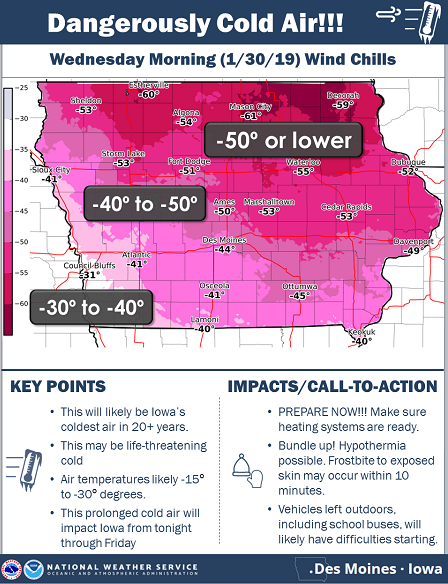
Forecasters predict this will be Iowa’s coldest snap in more than 20 years. In addition to protecting yourself from this extreme cold, Mortensen says pets should remain indoors.
Today: **Wind Chill Advisory 6-a.m. To 6-p.m. today** Partly cloudy. High around 10 early, w/tempts falling to around 0 degrees this afternoon. NW @ 15-30 mph. Wind chill values as low as -25.
Tonight: **Wind Chill Warning 6-p.m. today til 6-p.m. Wednesday**. P/Cldy to Cldy. Low -20. NW @ 10-20. Wind chill values as low as -40.
Tomorrow: P/Cldy. High -3. NW @ 10-15. Wind chill values as low as -40. **Wind Chill Advisory 6-p.m. Wednesday thru 9-a.m. Thursday**
Thursday: Mo.Cloudy w/light snow or flurries. High 12.
Friday: P/Cldy to Cldy. High around 27.
Yesterday’s High in Atlantic was 14. Our Low this morning 1. Last year on this date our High was 27 and the Low was 7. The record High in Atlantic on this date was 59 in 1931. The Record Low was -31 in 1904.
OMAHA, Neb. (AP) — The National Weather Service says high winds whipping eastern Nebraska and western Iowa could knock down trees and limbs and knock out power to thousands of people. The service has issued high wind warnings and advisories to the area for Monday. The sustained winds are blowing 30 mph to 45 mph, with gusts up to 65 mph. Forecasters say travel will be tough, especially for high-profile vehicles. The high winds also will make the low temperatures feel even colder.
Omaha Public Power District says 415 customers were without power at 7:15 a.m. MidAmerican Energy reports fewer than 100 customers were without power on the west side of Iowa. Snow and low temperatures prompted some schools to close or start late in eastern Iowa.
Today: A 40 percent chance of snow, mainly after 10am. Cloudy, with a high near 30. Wind chill values as low as -5. Breezy, with a light and variable wind becoming south 11 to 16 mph in the morning. Winds could gust as high as 23 mph. Total daytime snow accumulation of less than a half inch possible.
Tonight: Rain, snow and sleet, possibly mixed with freezing rain before 1am, then a chance of rain and snow between 1am and 2am, then a chance of snow after 2am. Low around 16. Windy, with a south wind 15 to 23 mph becoming west northwest after midnight. Winds could gust as high as 31 mph. Chance of precipitation is 80%. Little or no ice accumulation expected. New snow and sleet accumulation of less than a half inch possible.
Monday: Partly sunny, with a temperature falling to around 7 by 5pm. Wind chill values as low as -15. Windy, with a north northwest wind 21 to 28 mph, with gusts as high as 41 mph.
Monday Night: Partly cloudy, with a low around 0. Wind chill values as low as -15. Blustery, with a west northwest wind 8 to 17 mph, with gusts as high as 25 mph.
Tuesday: Mostly sunny and cold, with a high near 7. Windy, with a northwest wind 11 to 16 mph increasing to 17 to 22 mph in the afternoon. Winds could gust as high as 33 mph.
Wednesday: Sunny and cold, with a high near -4.
Yesterday’s High in Atlantic was 38. Our Low was 6. We received .02″ rain/freezing rain overnight. Last Year on this date, the High in Atlantic was 26 and the Low was 8. The All-Time record High in Atlantic on this date was 58 in 1931 & 2015. The Record Low was -23 in 1915.


