
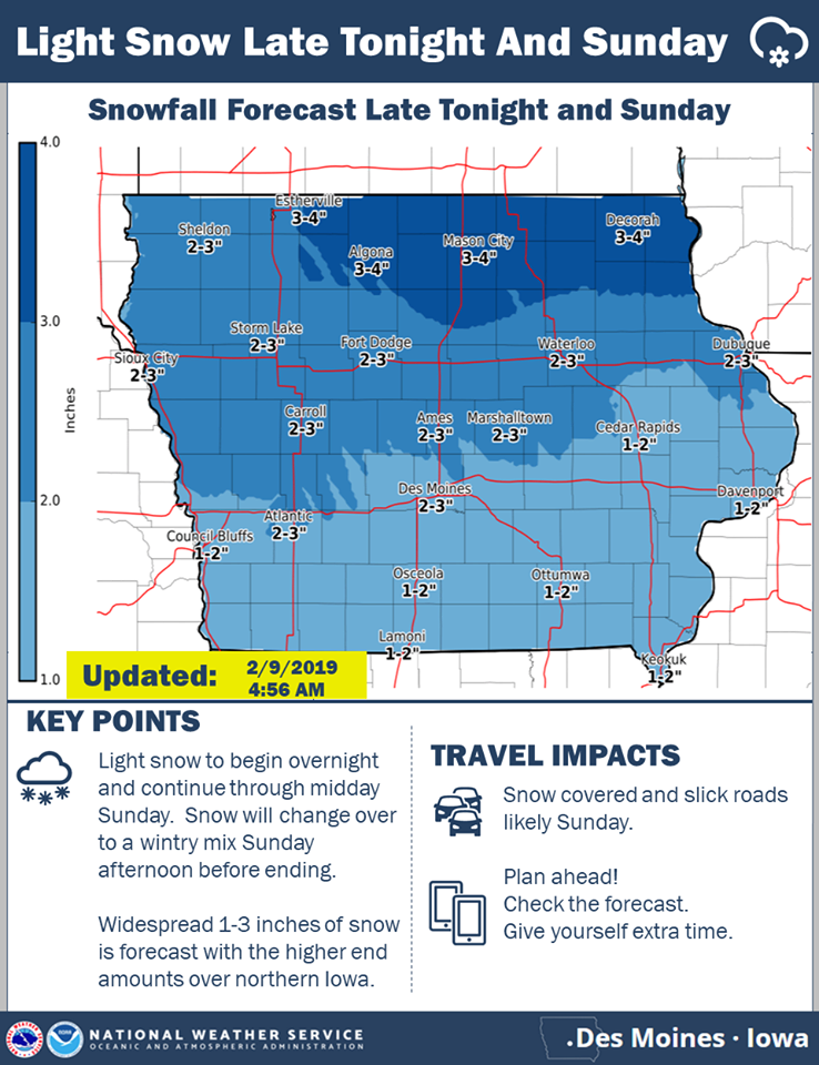
The National Weather Service this (Saturday) morning, said they are still tracking two winter systems to impact Iowa through Tuesday. The first one still to bring light snow to much of Iowa late tonight through Sunday. Some light freezing drizzle may mix with with the snow as precipitation ends late Sunday.
A stronger winter storm system is then slated to impact Iowa Monday into Tuesday. Precipitation is expected to spread across Iowa Monday as a light wintry mix, then change to snow Monday evening and continue into Tuesday. Moderate to heavy accumulations of snow are more likely across the northern half of the state. Uncertainty still high with snow amounts given uncertainty in the track and strength of this system. Northwest winds will increase across the state Tuesday and be strong and gusty through the day into Tuesday evening. This will allow for blowing and drifting snow. Travel may be difficult across the state Tuesday with snow-packed roads and significantly reduced visibilities possible.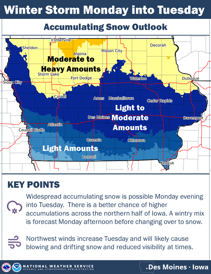
click on the graphic to enlarge
Today: Partly cloudy-to cloudy. High 26. SE @ 10-20. Wind Chill as low as -10.
Tonight: Mostly Cloudy w/light snow developing late. Low 22.. SE @ 5. WC 5.
Tomorrow: Cloudy w/snow (2-4” total possible). High 28. E @ 10-15.
Monday: Mo. Cldy w/a chance of afternoon snow. High around 30.
Tuesday: Cldy w/snow in the morning. High 28.
Yesterday’s High in Atlantic was 13. Our Low was -5. Last year on this date our High was 14 and the Low was 1. The record High in Atlantic on this date was 59 in 1954, 2000 & 2009. The Record Low was -36 in 1975.
(Radio Iowa) — New forecasts predict a rising risk for flooding across western Iowa in the weeks and months ahead. The U-S Army Corps of Engineers reports it has moved all excess water out of Missouri River reservoirs to prepare for this year’s runoff. Hydrologist Kevin Low, with the Missouri Basin River Forecast Center of the National Weather Service, says mountain snowpack is on trac
“Snowpack conditions in the mountains can be generally described as about normal for this time of year,” Low says. “By this point, we’d have normally accumulated about 60%, a little more maybe, of the seasonal peak snow-water equivalent in the mountains. We still have plenty of accumulating season left and much could change.” Given the snowfall so far and based on previous decades of record-keeping, Low says a runoff forecast is being released.
“The February water supply forecast developed by the National Weather Service projects a slightly below-average runoff volume for the 2018 season,” Low says. In spite of that, he says there will probably be some flooding on tributaries of the Missouri River this spring. “Areas likely to experience tributary flooding include eastern South Dakota, western Iowa, eastern Nebraska, eastern Kansas and across the state of Missouri,” Low says. “The wet soils have enhanced the chances for flooding in these areas for this spring.”
The first flood forecast of the season will be released later this month.
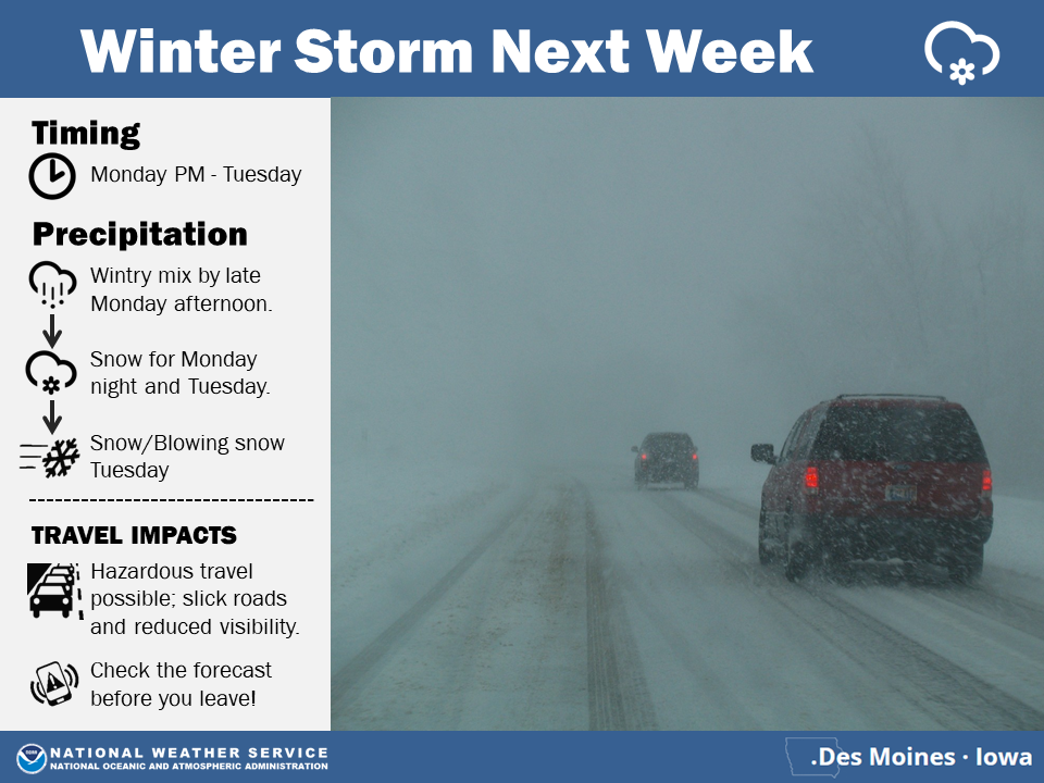
The National Weather Service reports two winter weather systems to impact the state through early next week. One will bring light snow to much of the state early Sunday morning through Sunday afternoon. The second stronger system will bring another potential winter storm to impact Iowa late Monday through Tuesday night.
Click on the graphic to enlarge
Today: **Wind Chill Advisory until Noon** Mostly sunny. High 12. NW @ 10-15. WC as low as -25.
Tonight: Fair to Partly Cloudy. Low -4. SE @ 5.
Tomorrow: P/Cldy to Cldy. High 26. SE @ 10-20. WC -10.
Sunday: Mo. Cldy w/a chance of snow. High 28.
Monday: Mo. Cldy w/a chance of afternoon snow. High around 30.
Yesterday’s High in Atlantic was 8. We received .6” new snow (.01” liquid). Our Low this morning was -5. Last year on this date our High was 25 and the Low was 2. The record High in Atlantic on this date was 62 in 1954. The Record Low was -34 in 1971.
(Radio Iowa) — More wicked weather is snarling traffic and freezing fingers across much of Iowa. The entire state is under a Winter Weather Advisory, an Ice Storm Warning is in effect for southeast Iowa, while a Blizzard Warning is posted for northwest and north-central Iowa. Meteorologist Mindy Beerends, at the National Weather Service in Johnston, says only a few inches of snow are predicted but the winds will be whipping up whatever falls, potentially causing white-out conditions. “Winds will be strong enough that we are expected to see blizzard conditions, starting late morning in northwestern Iowa and into the afternoon in north-central Iowa,” Beerends says. “That looks to continue through the evening hours with winds gusting 40 to 45-miles an hour at times.”
Another round of frigid, arctic air will arrive in Iowa shortly. “Tonight, we could see wind chills dipping to between 30-below and 40-below in parts of far northern Iowa and then between 20-below and 30-below for portions of central and southern Iowa,” Beerends says. “Those bitter cold wind chills will continue tonight into tomorrow morning and the temperatures will drop again Friday night, looking at lows around ten-below to teens-below in far northern Iowa.”
The long-range forecast calls for more chances for snowfall on Sunday and again on Monday night and into Tuesday
Today: **Winter Weather Advisory (for mixed precip) until 6-p.m.** Cloudy & windy w/light snow this morning & flurries this afternoon. High 10. NW @ 20-40 mph. WC -15. Total snow around 1″.
Tonight: Becoming Partly Cloudy. Low -8. NW @ 10-15. WC -25.
Tomorrow: Mostly sunny. High 12. N @ 5-10. WC -25.
Saturday: P/Cldy to Cldy. High 28.
Sunday: Cldy w/a chance of snow (mainly before noon). High 28.
Yesterday’s High in Atlantic was 18. Our Low this morning: 6. We received a .9” snow, sleet and freezing drizzle from 7-a.m. Wed., through 7-a.m. Today, which amounted to .1” liquid value. Last year on this date our High was 18 and the Low was 4. The record High in Atlantic on this date was 64 in 1987. The Record Low was -30 in 1905.
Today: **Winter Weather Advisory in effect from Noon today until Noon Thursday** Cloudy w.a mix of light snow/freezing drizzle/sleet eventually changing over to snow. High near 25. NE @ 10-15. Wind chill values as low as zero.
Tonight: Cloudy w/snow, possibly mixed with freezing rain, becoming all snow after 4-am Thursday. Low around 12. N @ 15-25, Wind chill values as low as zero. New ice accumulation of less than a 0.1 of an inch possible. New snow accumulation of less than a half inch possible.
Tomorrow: Mo. Cldy w/snow likely, mainly before 11am. Patchy blowing snow. High around 12 w/the temperature falling into the single digits. N @ 20-40. Wind chill values as low as -15. New snow accumulation of less than one inch possible.
Friday: Partly cloudy. High 10.
Saturday: P/Cldy to Cldy. High 26.
Yesterday’s High in Atlantic was 17. Our Low was 8. We received a trace of sleet and snow yesterday. Last year on this date our High was 10 and the Low was -13. The record High in Atlantic on this date was 54 in 1966. The Record Low was -27 in 1982.
Today: Increasing clouds w/a chance of light rain-freezing drizzle-snow mainly this afternoon. High 26. E @ 5-10.
Tonight: Cloudy w/light snow-freezing drizzle ending (<1″ snow). Low 18. N @ 5-10.
Tomorrow: Cldy w/light snow-freezing drizzle mainly in the afternoon. High around 31. W @ 5-10.
Thursday: Cldy w/light snow. Nearly steady temp in the lower teens. NW @ 15-40.
Friday: P/Cldy. High around 12.
Yesterday’s High in Atlantic was 20. We had a trace of snow Monday morning. Our Low this morning (as of 5-a.m.) was 8. Last year on this date our High was 15 and the Low was -13. The record High in Atlantic on this date was 66in 1948. The Record Low was -26 in 1936.
(Radio Iowa) — Iowans are used to wild weather extremes in the wintertime but going from balmy highs in the 60s to wind chills of minus-60 in the course of several days is radical, even for the Hawkeye State. State climatologist Justin Glisan says the month of January started out quite warm and stayed that way -almost- through the end. “Up until the 27th of January, the state was above average temperature-wise,” Glisan says, “and then we got that polar plunge the last few days that really tipped the averages.”
It was almost like somebody roused a dozing Mother Nature from her slumber last Sunday and reminded her it’s supposed to be winter in Iowa — and she overreacted a bit. “You look at the first week of January, we were actually way above average, between 15 to 25-degrees above average. Some parts of the state had temperatures in the 50s and 60s,” Glisan says. “You flip that, the last week of the month, we’re getting temperatures down into negative-30 and negative-40.”
Overall, the statewide average temperature for January was 18-point-five degrees, about one-degree below normal. Glisan says it appears February will remain colder than normal. “We’re looking to trend below-average for the month,” Glisan says. “We’re getting into the later part of wintertime so we’re warming up, but as of now, the outlooks have below-average temperatures. As for precipitation, it looks like we’re a tad bit above average for rainfall/snowfall across the state.”
Precipitation for January statewide averaged one-point-32 inches, which is four-tenths of an inch above normal. He notes, January is typically the driest month of the year.


