
A Flood Warning continues for the following Counties in IA:
PRECAUTIONARY/PREPAREDNESS ACTIONS…
Do not drive cars through areas where water covers the road. The water depth may be too great to allow your vehicle to pass safely. Turn around…don`t drown!
Today: Partly sunny, then gradually becoming sunny, with a high near 47. West northwest wind 5 to 10 mph.
Tonight: Mostly clear, with a low around 25. North northwest wind 5 mph.
Monday: Mostly sunny, with a high near 43. North northwest wind around 6 mph.
Monday Night: A 20 percent chance of snow after 1am. Mostly cloudy, with a low around 29. Calm wind becoming south around 5 mph after midnight.
Tuesday: A chance of snow before 10am, then a chance of rain. Cloudy, with a high near 44. South wind 5 to 10 mph. Chance of precipitation is 50%. New snow accumulation of less than a half inch possible.
Tuesday Night: A chance of rain and snow before midnight, then a chance of snow between midnight and 1am. Mostly cloudy, with a low around 30. Chance of precipitation is 40%. New precipitation amounts of less than a tenth of an inch possible.
Wednesday: Partly sunny, with a high near 49.
Saturday’s High in Atlantic was 54. Our Low was 26. Last year on this date, the High in Atlantic was 37 and the Low was 33. The Record High on March 17th was 84 in 1894. The Record Low was -11, in 1906.
Iowa Counties: Mills-Fremont-Harrison-Pottawattamie
The National Weather Service in Omaha has issued a Flood Warning for…
Mills County…Fremont County…Harrison County…Pottawattamie County.. Until 1115 AM CDT Sunday.
Rivers and streams continue to be at record levels and have expanded to areas unaccustomed to flooding. Travel is still hazardous, and is discouraged. Please do not drive across flooded roadways.
PRECAUTIONARY/PREPAREDNESS ACTIONS…
Turn around, don`t drown when encountering flooded roads. Most flood deaths occur in vehicles. Excessive runoff from heavy rainfall will cause flooding of small creeks and streams, country roads, farmland, and other low lying spots.
Stay away or be swept away. River banks and culverts can become unstable and unsafe. A Flood Warning means that flooding is imminent or occurring. All
interested parties should take necessary precautions immediately.
Flood Warnings remain in place Saturday for the Western and Southwestern Counties in the KJAN listening area. Here is a look at the warnings still in place.
…A FLOOD WARNING REMAINS IN EFFECT UNTIL 830 PM CDT SATURDAY FOR
CARROLL…SAC…CRAWFORD COUNTIES…
At 427 AM CDT, emergency management reported flooding across the
warned area. Several roadways, especially secondary roadways,
remain closed.
* Flood Warning for…
Mills County in southwestern Iowa…
Shelby County in southwestern Iowa…
Monona County in west central Iowa…
Pottawattamie County in southwestern Iowa…
Montgomery County in southwestern Iowa…
Fremont County in southwestern Iowa…
Harrison County in southwestern Iowa…
Page County in southwestern Iowa…
* Until 945 AM CDT Saturday.
* At 943 AM CDT, residual extensive flooding continues today, as
rivers and streams expand to areas unaccustomed to flooding.
Travel is still hazardous, and is discouraged. Please do not drive
across flooded roadways.
PRECAUTIONARY/PREPAREDNESS ACTIONS…
Turn around, don`t drown when encountering flooded roads. Most flood
deaths occur in vehicles.
Excessive runoff from heavy rainfall will cause flooding of small
creeks and streams, country roads, farmland, and other low lying
spots.
A Flood Warning means that flooding is imminent or occurring. All
interested parties should take necessary precautions immediately.
The Flood Warning continues for…
Missouri River At Decatur affecting Monona…Thurston and Burt Counties.
Missouri River Near Blair affecting Harrison and Washington Counties.
Missouri River At Omaha affecting Douglas…Pottawattamie and Sarpy Counties.
Missouri River At Nebraska City affecting Fremont and Otoe Counties.
Missouri River At Brownville affecting Nemaha and Atchison Counties.
Missouri River At Rulo affecting Holt and Richardson Counties.
The Flood Warning continues for
The West Nishnabotna River At Randolph.
* At 3:00 AM Saturday the stage was 23.8 feet…or 4.8 feet above
flood stage.
* Flood stage is 19.0 feet.
* Moderate flooding is occurring and Moderate flooding is forecast.
* Forecast…The river will continue to fall to below flood stage by
early tomorrow.
* Impact…at 23.0 feet…County road J18 (120th Street) west of
Randolph begins to flood.
The Flood Warning continues for
The Nishnabotna River Above Hamburg.
* At 2:45 AM Saturday the stage was 29.1 feet…or 4.1 feet above
flood stage.
* Flood stage is 25.0 feet.
* Moderate flooding is occurring and Moderate flooding is forecast.
* Forecast…The river will continue rising to near 29.4 feet by this
evening. The river will fall below flood stage Tuesday afternoon.
* Impact…at 27.5 feet…State Highway 275 south of the gage may be
threatened in several spots.
Skyscan Forecast Saturday, March 16, 2019 Dan Hicks
Today: Partly to mostly sunny. W @ 10-15. High 48.
Tonight: Partly cloudy. N @ 5-10. Low 25.
Sunday: Partly cloudy. NW @ 10-15. High 46.
Monday: Partly cloudy. High 44.
Tuesday: Partly cloudy to cloudy. A few showers. High 42.

Podcast: Play in new window | Download (530.3KB)
Subscribe: RSS
The Atlantic Police Department reports four local streets have been temporarily closed due to severe damage from the flooding. The streets are primarily in the vicinity of the Schildberg Recreation Area, and include:
The Schildberg Recreation Park, including the walking path, tree dump/yard waste site and dog park, will all be closed until further notice. In addition, there are 5 roads in Cass County closed by washouts. Assistant to the Cass County Engineer Rich Hansen reports:
Cass County Emergency Management Coordinator Mike Kennon is asking County residents with flood-related property damage, to call him at 243-1500, or 254-1500, to report the type of damage and other pertinent information. The data will be submitted to the State in hopes of obtaining Individual Assistance Grants for the County, that will help residents recover from flood damage.
The National Weather Service has extended a Flood Warning for certain western and southwest Iowa Counties through 9:45-a.m. Saturday, March 16th. Counties still under a Flood Warning include: Mills-Shelby-Monona-Pottawattamie-Montgomery-Fremont-Harrison and Page. At 9:43-a.m. today (Friday), residual extensive flooding continued as rivers and streams expand to areas unaccustomed to flooding. Travel is still hazardous, and is discouraged. Please do not drive across flooded roadways.
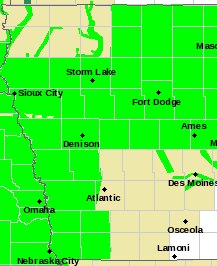
Flood Warning for counties/areas in bright green.
PRECAUTIONARY/PREPAREDNESS ACTIONS…
Turn around, don`t drown when encountering flooded roads. Most flood deaths occur in vehicles. Excessive runoff from heavy rainfall will cause flooding of small creeks and streams, country roads, farmland, and other low lying spots. A Flood Warning means that flooding is imminent or occurring. All interested parties should take necessary precautions immediately.
The Flood Warning for Cass-Adair-Adams-Audubon-Guthrie-Ringgold-Taylor and Union Counties was allowed to expire this morning.
Today: *FLOOD WARNING until 10:15-a.m.* Partly cloudy & windy. High 42. NW @ 15-30 mph.
Tonight: P/Cldy. Low 20. NW @ 5-10.
Tomorrow: P/Cldy. High 46. W @ 10.
Sunday: P/Cldy. High 46.
Monday: P/Cldy. High 44.
Yesterday’s High in Atlantic was 40. Our Low this morning (as of 7-a.m.) was 29. Rainfall at KJAN yesterday was .06” (for a total of .97″ over the past few days). Last year on this date our High was 59 and the Low was 26. The record High in Atlantic on this date was 79 in 2003. The Record Low was 0 in 1944.
According to 511ia.org, the following roads remain closed or are partially open, in the listening area, due to flooding:
Counties: Madison-Audubon-Adair-Cass-Union-Guthrie-Adams-Ringgold-Taylor-Dallas…A FLOOD WARNING FOR URBAN AREAS AND SMALL STREAMS FOR RAIN AND SNOWMELT REMAINS IN EFFECT UNTIL 1015 AM CDT FRIDAY
Local law enforcement and Iowa DOT have reported flooding across the warned area. This has been a result of rain and snow melt over the last two days. There have been a few state highways throughout the warned area thatare closed due to flooding.
Several gravel roads have become too saturated to safely operate a vehicle on. In addition, several local creeks and streams have had rapid responses. Flooding on roads overnight will be difficult to spot.
A FLOOD WARNING CONTINUES until 9:30-a.m. today for the following:
PRECAUTIONARY/PREPAREDNESS ACTIONS…
Turn around, don`t drown when encountering flooded roads. Most flood
deaths occur in vehicles.
Be especially cautious at night when it is harder to recognize the
dangers of flooding.
In hilly terrain there are hundreds of low water crossings which are
potentially dangerous in heavy rain. Do not attempt to cross flooded
roads. Find an alternate route.


