
Today: A 20 percent chance of showers before 8am. Cloudy, with a high near 55. Windy, with a west northwest wind 9 to 14 mph increasing to 16 to 21 mph in the afternoon. Winds could gust as high as 31 mph.
Tonight: Mostly cloudy, with a low around 40. Breezy, with a northwest wind 9 to 18 mph, with gusts as high as 28 mph.
Monday: Showers likely, mainly after 4pm. Increasing clouds, with a high near 58. North wind 8 to 10 mph becoming east in the afternoon. Chance of precipitation is 60%. New precipitation amounts of less than a tenth of an inch possible.
Monday Night: Showers likely, with thunderstorms also possible after 1am. Cloudy, with a low around 49. Windy, with an east wind 10 to 15 mph increasing to 16 to 21 mph after midnight. Winds could gust as high as 31 mph. Chance of precipitation is 70%. New rainfall amounts between three quarters and one inch possible.
Tuesday: Showers and possibly a thunderstorm before 1pm, then showers and thunderstorms likely after 1pm. High near 62. Windy, with an east wind 20 to 23 mph, with gusts as high as 33 mph. Chance of precipitation is 80%. New rainfall amounts between 1 and 2 inches possible.
Tuesday Night: A 40 percent chance of showers before 1am. Mostly cloudy, with a low around 53. Breezy. New precipitation amounts between a tenth and quarter of an inch possible.
Wednesday: Mostly sunny, with a high near 78. Windy.
Yesterday’s High in Atlantic was 79. We received .43” rain overnight. Our Low this morning, 56. Last year on this date our High was 74 and the Low was 54. The record High in Atlantic on this date was 94 in 1934 & 1975. The Record Low was 22 in 1894.
(Radio Iowa) — While parts of Iowa had record high temperatures in the low 90s on Thursday, forecasters say cooler, wetter weather will likely dominate much of the rest of the month and well into June. During a National Weather Service briefing, climatologist Martha Shulski (SHUL-skee) says heavy rain will spread across Iowa and much of the Northern Plains next week, raising the critical risk of renewed flooding. “The prediction is in the three-to-five inch range, so a pretty active pattern,” Shulski says. “These forecasts have been pretty consistent which gives you some higher confidence in the forecast actually verifying. Certainly, it’s something to look out for in terms of impacts over the next week.”
In spite of a few scattered hot and humid days, Iowa’s weather has been much cooler than normal this spring and forecasters anticipate that pattern will remain. “Continued higher probability for below-normal temperatures for a swath in the central U.S.,” Shulski says. “This is combined with the increased probability of wetter-than-normal conditions for June.”
Thanks to the El Nino, it’s possible the cool, wet weather will last well into summer, as will the risk of more flooding, as the ground remains saturated in many parts of the state.
Today: Occasional showers and thunderstorms. High near 80. South wind 13 to 15 mph, with gusts as high as 26 mph. Chance of precipitation is 80%. New rainfall amounts between a quarter and half of an inch possible.
Tonight: Showers and thunderstorms before 10pm, then showers and possibly a thunderstorm, mainly after 10pm. Low around 52. South southwest wind 5 to 10 mph becoming north after midnight. Chance of precipitation is 90%. New rainfall amounts between three quarters and one inch possible.
Sunday: A 30 percent chance of showers before 1pm. Mostly cloudy, with a high near 59. Breezy, with a west northwest wind 13 to 18 mph, with gusts as high as 28 mph. New precipitation amounts between a tenth and quarter of an inch possible.
Sunday Night: Mostly cloudy, with a low around 40. Northwest wind 7 to 15 mph, with gusts as high as 22 mph.
Monday: A 20 percent chance of showers after 1pm. Partly sunny, with a high near 61.
Tuesday: Showers and possibly a thunderstorm before 1pm, then showers and thunderstorms likely after 1pm. High near 66. Windy. Chance of precipitation is 80%.
Yesterday’s High in Atlantic was 85. We received .54” rain during the day. Our Low thos morning, 64. Last year on this date our High was 85 and the Low was 57. The record High in Atlantic on this date was 94 in 1934. The Record Low was 32 in 1891.
(Update 5-a.m.)
Today: Variably cloudy w/scattered showers & thunderstorms. High 83. S/SE @ 15-25.
Tonight: Partly cloudy to cloudy w/scattered showers & thunderstorms. Low 67. S @ 5-10.
Tomorrow: P/Cldy to Cldy w/scattered shwrs & tstrms. High 83. SW @ 10-20.
Sunday: Mo. Cldy w/showers & thunderstorms mainly in the morning. High 64.
Monday: P/Cldy to Cldy. High 70.
Yesterday’s High in Atlantic was 92 (one degree shy of tying the record). Rainfall overnight amounted to .34″ (as of 5-a.m.) Our Low (as of 5-a.m. Today) was 64. Last year on this date our High was 84 and the Low was 55. The record High in Atlantic on this date was 92 in 1908 & 1939. The Record Low was 32 in 1912 & 1973.
(Radio Iowa) — Near-record heat is in today’s (Thursday) forecast, with 80s expected across northern Iowa and low 90s for Iowa’s southern half. With the hot, humid air comes the greater risk of severe weather. Meteorologist Brooke Hagenhoff, at the National Weather Service in metro Des Moines, says some areas may see summer-like temperatures 20-degrees hotter than usual. “While we’ve been cooler-than-normal for most of May so far, it’s a pretty big change here, especially today, the warmest day in our seven-day forecast,” Hagenhoff says. “It’s really due to the increased southerly flow which is allowing warmer air to come up across the Southern United States and into Iowa.”
With the dramatic change as we shift from cooler to much warmer weather, there’s always the risk of rough weather, including powerful thunderstorms. “For today, we’re looking at a risk over mainly central and northern Iowa and the main threat with that is going to be hail and possibly damaging winds,” Hagenhoff says. “That will be mostly confined to this evening and tonight.” Many Iowans are rarely very far from their smart phones, which can be set up to provide you with potentially-life-saving weather data. “We know that with the warmer weather, after the cool start to spring, a lot of people are antsy to get outside,” Hagenhoff says. “It’s important that whether you have outdoor plans or not that you have ways while you’re outside to receive severe weather warnings and information, just so you’re prepared.”
The weather should cool a bit Friday and Saturday, she says, with highs by Sunday only creeping into the 60s. On the subject of severe weather, Iowa saw 69 tornadoes touch down last year. So far this year, there hasn’t been a single twister reported statewide.
(Radio Iowa) — We’re now at the halfway mark of tornado season in Iowa, and so far, there hasn’t been a single twister reported statewide this year. While tornadoes can strike during any month, April, May and June are considered the peak months. Meteorologist Chad Hahn, at the National Weather Service, says there is a reason why it’s been such a quiet period for the storms. “Of course, we’ve been experiencing a great deal of precipitation and certainly we’ve seen that with the ongoing river flooding across portions of the state,” Hahn says. “We’ve been cooler than normal over the past few weeks and because of that, we haven’t been able to get the thunderstorm activity going like we’d typically expect in the spring months here.”
After the prolonged cold spell, warmer weather should be moving in over the next few days. Hahn says that could bring a chance of thunderstorms, though likely nothing too rough. “At least at this point, the week looks fairly quiet, but we do see the mercury starting to rise off in the horizon,” Hahn says. “Of course, it’s not a matter of if, it’s when. We can’t let our guard down because we know when that switch flips, we’ll have to be ready to take the appropriate action if we have severe weather.” Hahn says Iowans should be prepared. “I encourage the public to know that we will get severe weather,” he says. “It’s not a matter of if, it’s when. When that does happen, it’ll likely go from zero to 60, so we need to battle the complacency bug and be ready for severe weather when it does strike.”
Last year, there were 69 tornadoes statewide with the most notable hitting Bondurant, Marshalltown and Pella on July 19th. Over the past decade, Iowa has seen as few as 16 tornadoes during all of 2012 and as many as 88 tornadoes in 2014.
Today: Partly cloudy. High around 90. S @ 10-20.
Tonight: Partly cloudy w/isolated showers & thunderstorms late. Low 67. S @ 5-10.
Tomorrow: P/Cldy to Cldy w/scattered shwrs & tstrms. High 84. S @ 10-20.
Saturday: P/Cldy w/scattered shwrs & tstrms. High near 84.
Sunday: Mo. Cldy w/showers & thunderstorms mainly in the morning. High 66.
Yesterday’s High in Atlantic was 82. Our Low was 51. Last year on this date our High was 85 and the Low was 55. The record High in Atlantic on this date was 93 in 1939. The Record Low was 25 in 1907.
The National Weather Service reports a few storms will be possible late tonight (Wednesday night) into Thursday morning, with more widespread thunderstorms possible Thursday evening into Thursday night. A few strong to severe storms will be possible Thursday night with large hail and damaging winds the main severe threats. Greater chances for severe storms are possible Friday into Saturday. Temperatures will warm into the 70s to around 80 today with much warmer conditions and increasing humidity for Thursday. Highs Thursday will top out in the mid 80s to around 90 degrees in some spots. 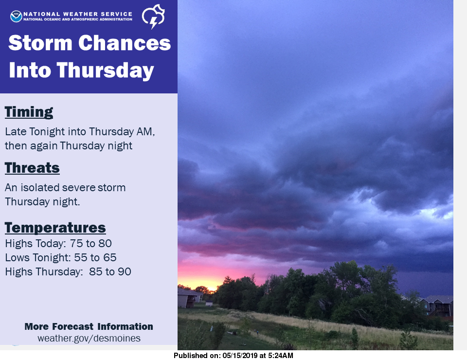
Today: Mostly Sunny. High around 80. SE @ 5-10.
Tonight: Partly cloudy. Low 61. S/SE @ 5-10.
Tomorrow: Mostly sunny. High 88. SW @ 10-20 w/gusts to near 25.
Friday: Mo. Sunny & breezy. High near 84. S @ 15-25.
Saturday: Mo. Cldy w/showers & thunderstorms mainly in the afternoon. High 77.
Sunday: Mo. Cldy w/scattered shwrs & tstrms. High 69.
Yesterday’s High in Atlantic was 82. Our Low this morning (as of 5-a.m.) was 50. Last year on this date our High was 79 and the Low was 52. The record High in Atlantic on this date was 91 in 1894 & 2017. The Record Low was 29 in 1929, 1973 & 1983.


