
SEVERE THUNDERSTORM WATCH OUTLINE UPDATE FOR WS 447
NWS STORM PREDICTION CENTER NORMAN OK
WED JUN 26 2019
SEVERE THUNDERSTORM WATCH 447 IS IN EFFECT UNTIL 1000 AM CDT
FOR THE FOLLOWING LOCATIONS…. IOWA COUNTIES INCLUDED ARE
FREMONT HARRISON MILLS POTTAWATTAMIE
Union IA-Adams IA-Ringgold IA-
1249 AM CDT Wed Jun 26 2019
…THE FLASH FLOOD WARNING REMAINS IN EFFECT UNTIL 615 AM CDT FOR
SOUTHERN UNION…SOUTHEASTERN ADAMS AND NORTHERN RINGGOLD COUNTIES…
At 1245 AM CDT, Union County law enforcement reported flash flooding
in near Kent Corner across Highway 34. Highway 34 is closed to
traffic in both directions at this location. Doppler radar
estimates of 6 or more inches of rain has fallen across this area.
Flash flooding is already occurring.
Some locations that will experience flooding include…
Creston, Lenox, Sun Valley Lake, Tingley, Cromwell, Arispe, Shannon
City, Kent, Ellston, Beaconsfield and Creston Municipal Airport.
Additional rainfall amounts of 1 to 2 inches is possible in the
warned area over the next couple of hours.
PRECAUTIONARY/PREPAREDNESS ACTIONS…
Be especially cautious at night when it is harder to recognize the
dangers of flooding. Avoid flooded areas and if water is
encountered, Turn Around, Don`t Drown.
A Flash Flood Warning means that flooding is imminent or occurring.
If you are in the warned area move to higher ground immediately.
Residents living along streams and creeks should take immediate
precautions to protect life and property.
6/26
1:32-a.m. 3 miles NW of Kent in Adams County – U.S. Highway closed due to flooding over the road between County Road N-64 and IA Hwy 25, about 4 miles W. of Cromwell.
1:20-a.m. 1.5″ diameter hail (ping pong ball size), w/some larger than a half-dollar coin, 6 miles S/SE of Bridgewater – Adair County
1:11-a.m. 1″ diameter hail 6 miles S. of Bridgewater
12:41-a.m. Hwy 34 closed in both directions at the Kent corner due to water over the road.
12:34-a.m. Flash Flooding over several roads near Prescott.
12:01-a.m. 1″ diameter hail (Quarter size), along with various other sizes of hail, 7 miles N/NW of Prescott – Adams County
6/25
9:35-p.m. Quarter size hail (1″ diameter) 4 miles NE of Prescott – Adams County
8:42-p.m. Golf ball size hail (1.75″) in Prescott – Adams County
5:50-p.m. 1″ hail in Creston (Law enforcement reported nickel-to-quarter size hail) – Union County
5:40-p.m. 1″ hail 4 miles NW of Cromwell – Adams County
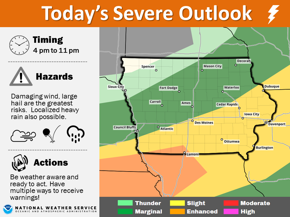
The National Weather Service reports a weak cold front will drop into Iowa today with a few scattered showers and storms through midday. Some strong to severe storms are forecast to develop ahead of the boundary in southern Iowa by late afternoon. These storms will continue into the evening with the threat of damaging winds and large hail. Localized heavy rainfall is also possible before the storms move out of the state by late evening. Be prepared for the potential of severe storms in southern Iowa later today!
Today: Partly cloudy to cloudy, w/scattered showers this morning & again later today. High 84. W @ 10-15.
Tonight: Any showers will be ending; P/Cldy. Low 64. Winds light & variable.
Tomorrow: P/Cldy w/isolated afternoon showers. High 87. S @ 10-15.
Thursday: P/Cldy to cloudy w/isolated showers. High around 85.
Friday: P/Cldy. High 90.
Yesterday’s High in Atlantic was 80. Our Low was 61. Last year on this date our High was 75 and the Low was 64. The record High in Atlantic on this date was 106 in 1937. The Record Low was 40 in 2004.
Today: Partly cloudy to cloudy, w/isolated showers & thunderstorms. High 78. NW @ 10-20.
Tonight: Any showers will be ending; P/Cldy. Low 63. Winds light & variable.
Tomorrow: P/Cldy. High 84. W @ 10.
Wednesday: P/Cldy w/isolated showers & thunderstorms. High around 87.
Thursday: P/Cldy to Cldy w/scatt. Shwrs. High around 85.
Yesterday’s High in Atlantic was 77. Our Low this morning (as of 5-a.m.) was 61. We received .16” rain Sunday into early this morning. Last year on this date our High was 86 and the Low was 64. The record High in Atlantic on this date was 105 in 1937. The Record Low was 41 in 1961.
Strong storms that made their way from southern through central Iowa Saturday, brought heavy rain and hail. Heavy rain fell in Greenfield during the eight o’clock hour, causing some temporary street flooding and resulting in at least one-stalled vehicle that drove into the flood waters about two-feet deep. The Greenfield Police Department’s automated weather system recorded at least 1.75 inches of rain as of last report. Pea-size hail and winds gusted up to an estimated 60-mph, as well.

Flooding on SE Kent Street in Greenfield, Saturday night. (Greenfield P-D social media post)
Nickel-size hail fell in the Ringgold County town of Diagonal at around 6:35-p.m., Saturday. Dime-size hail fell about two-miles northeast of Kent in Union County at around 7-p.m. Two-inches of rain fell in the Union County town of Cromwell in under 30-minutes, beginning at around 7-p.m. Winds gusting up to 50 mph were reported a little after 9-p.m. in the Des Moines suburb of Windsor Heights. Just before 10-p.m. the Des Moines International airport had recorded 2.5-inches of rainfall, but more than 4-inches fell on other parts of Des Moines, Saturday night.
Authorities said that between 9-p.m. Saturday and 6-a.m. Sunday, the Des Moines Police and Fire Departments had responded to over 100 reports of cars/people stranded on flooded roadways.

Image from the Dsm PD social media page: Flooding 6/22-23/19
There were no reports of injuries or serious property damage.
Today: Showers and thunderstorms likely, mainly between 10am and noon. Cloudy, with a high near 75. South wind around 7 mph. Chance of precipitation is 60%. New rainfall amounts between a tenth and quarter of an inch, except higher amounts possible in thunderstorms.
Tonight: Showers and thunderstorms likely, mainly before midnight. Mostly cloudy, with a low around 59. Northwest wind 6 to 11 mph. Chance of precipitation is 70%. New rainfall amounts between a quarter and half of an inch possible.
Monday: A 40 percent chance of showers and thunderstorms, mainly before 10am. Mostly cloudy, then gradually becoming sunny, with a high near 75. West wind 10 to 13 mph, with gusts as high as 23 mph. New precipitation amounts of less than a tenth of an inch, except higher amounts possible in thunderstorms.
Tuesday: Sunny, with a high near 84.
Wednesday: Mostly sunny, with a high near 86.
Yesterday’s High in Atlantic was 81. Our Low this morning 64. We received .64″ rain in Atlantic yesterday and overnight. Last year on this date, the High in Atlantic was 76 and the Low was 61. The Record High in Atlantic for June 23rd was 105 in 1937, and the Record Low was 44 in 1958.
Skyscan Forecast Saturday, June 22, 2019 Dan Hicks
Today: Partly cloudy to cloudy. Scattered showers and thunderstorms this morning, then redeveloping later this afternoon. ESE @ 10-20. High 80.
Tonight: Mostly cloudy. Scattered showers and thunderstorms. Low 65.
Sunday: Mostly cloudy. Scattered showers and thunderstorms. High 78.
Monday: Mostly cloudy with showers. High 76.
Tuesday: Partly cloudy. High 85.

Podcast: Play in new window | Download (692.0KB)
Subscribe: RSS
Today: Partly cloudy to cloudy w/scattered showers & thunderstorms this morning, & again later this afternoon. High near 80. E/SE winds @ 10-20 mph.
Tonight: Mostly cloudy w/scattered shwrs & tstrms. Low 65.
Tomorrow: Mo. Cldy w/scattered shwrs & tstrms. High 78.
Monday: Mo. Cldy w/showers. High 76.
Tuesday: P/Cldy. High around 85.


