
National Weather Service Des Moines IA 514 AM CDT Sat Aug 17 2019
Today and tonight: Strong to severe storms are possible late this afternoon and into the evening hours. The severe threats include large hail, damaging winds, and even a few tornadoes.
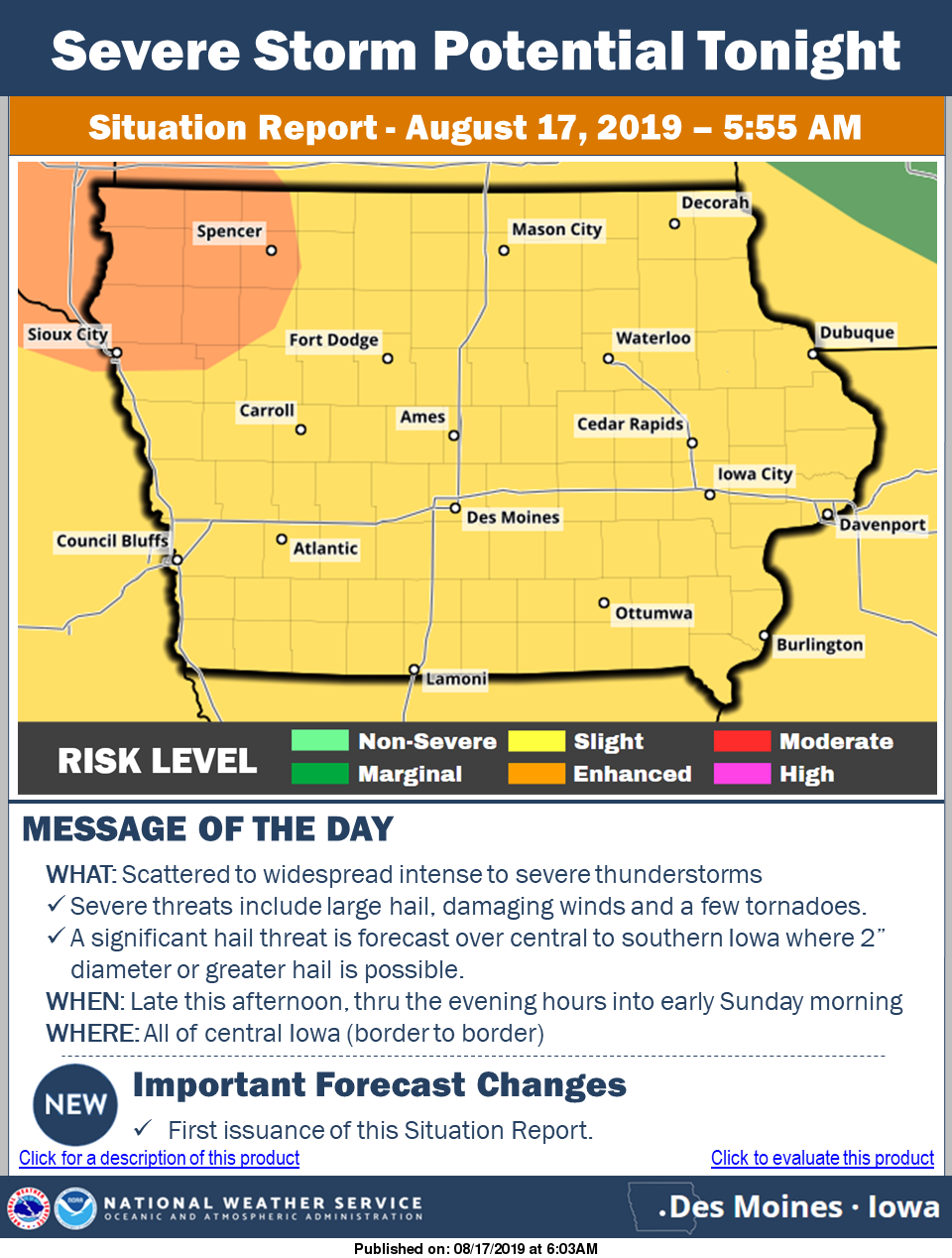
Click to enlarge the graphic
Sunday through Friday: Isolated storms are possible Sunday night into Monday and again on Tuesday. The severe weather risk is low. Hot and humid conditions return to the state on Monday and Tuesday where heat index values look to top 100 degrees.
SPOTTER INFORMATION STATEMENT…
Spotters are likely to be needed this afternoon and tonight.
Today: Mostly cloudy early this morning with a chance of showers; Becoming Partly cloudy. High 83. S @ 10mph.
Tonight: Mostly cloudy w/scattered showers late. Low 68. S @ 5.
Tomorrow: A chance of morning showers; P/Cldy. High around 80. NW@ 10.
Monday: P/Cldy. High 88.
Tuesday: P/Cldy w/scattered showers possible. High 88.
Yesterday’s High in Atlantic was 82. Our Low was 63. Last year on this date our High was 86 and the Low was 60. The record High in Atlantic on this date was 108 in 1936. The Record Low was 38 in 1897.
(Updated 11:30-a.m.) The National Weather Service in Des Moines reports there is a “Slight” risk for severe storms Saturday into Saturday night across the state and much of the region. Threats include hail and damaging winds over much of the state. There is a tornado threat across southwest Iowa. Locally heavy rain is anticipated at times as well.
Officials urge you to “Remain weather-ready Saturday into Saturday evening for the potential of storms in your area.” Monitor the latest forecast, and have a plan of action ready if severe weather threatens. Warmer temperatures are forecast by Monday and Tuesday.
Area Counties: Sac-Crawford-Carroll-Audubon-Guthrie-Dallas-Cass-Adair-Madison–
…Patchy Dense Fog This Morning…
Some fog has developed in patches across portions of central Iowa. A few sites are reporting visibility around one quarter mile or less. This dense fog seems to be relatively patchy, but could
become more widespread through sunrise. Be prepared for a quick reductions in visibility from greater than 6 miles to less than a mile over short distances for the morning commute.
Today: Areas of fog this morning & isolated showers; Partly cloudy. High 83. S @ 10-15 mph.
Tonight: Mostly cloudy w/scattered showers late. Low 68. S @ 5-10.
Tomorrow: A chance of morning showers; P/Cldy. High 87. S @ 10-15.
Sunday: A chance of morning showers, otherwise P/Cldy. High 87.
Monday: P/Cldy. High around 90.
Yesterday’s High in Atlantic was 76. Our Low this morning 58. We received .01″ rain at the KJAN studios, Thursday afternoon. Last year on this date our High was 82 and the Low was 64. The record High in Atlantic on this date was 105 in 1936. The Record Low was 48 in 1966.
Today: Areas of fog this morning; Increasing cloudiness w/a chance of showers this afternoon. High 80. SE @ 10 mph.
Tonight: Mostly cloudy w/scattered showers. Low 62. SE @ 5.
Tomorrow: A chance of morning showers; P/Cldy. High 85. S @ 10-15.
Saturday: A chance of morning showers, otherwise P/Cldy. High 87.
Sunday: P/Cldy. High 87.
Yesterday’s High in Atlantic was 76. Our Low this morning was 56. Last year on this date our High was 85 and the Low was 65. The record High in Atlantic on this date was 103 in 1937. The Record Low was 40in 1929.
Today: Partly cloudy. High 79. NW @ 10-20 mph.
Tonight: P/Cldy. Low 56. Winds light & variable.
Tomorrow: P/Cldy to cloudy. High 82. SE @ 5-10.
Friday: A chance of morning showers, otherwise P/Cldy. High 85.
Saturday: A chance of morning showers; P/Cldy. High 87.
Yesterday’s High in Atlantic was 86. Our Low this morning 58. Last year on this date our High was 75 and the Low was 66. The record High in Atlantic on this date was 107 in 1936. The Record Low was 45 in 1929.
Today: Areas of fog this morning; Partly cloudy. High 83. NW @ 10-15.
Tonight: Fair to P/Cldy. Low 60.
Tomorrow: P/Cldy. High 80. NW @ 10-15.
Thursday: P/Cldy. High 83.
Friday: P/Cldy to cldy w/scattered showers & tstrms. High 82.
Yesterday’s High in Atlantic was 84. Our Low this morning (as of 5-a.m.) 66. Last year on this date our High was 92 and the Low was 60. The record High in Atlantic on this date was 101 in 1913. The Record Low was 39 in 1964.
Rainfall early this morning in Atlantic added .4″ (four-tenths) of an inch to the 2.2-inches of rain we received here Sunday, at KJAN. Our total 24-hour rainfall was 2.6-inches.


