
Today: Showers and thunderstorms likely before 10am, then isolated showers and thunderstorms after 5pm. Mostly cloudy, then gradually becoming sunny, with a high near 83. South southwest wind 7 to 10 mph. Chance of precipitation is 60%. New rainfall amounts of less than a tenth of an inch, except higher amounts possible in thunderstorms.
Tonight: A 30 percent chance of showers and thunderstorms, mainly after 3am. Mostly cloudy during the evening, then clear overnight, with a low around 68. South wind 6 to 8 mph, with gusts as high as 21 mph. New rainfall amounts of less than a tenth of an inch, except higher amounts possible in thunderstorms.
Wednesday: A 30 percent chance of showers and thunderstorms, mainly before noon. Mostly sunny, with a high near 85. South wind 7 to 15 mph, with gusts as high as 25 mph. New rainfall amounts of less than a tenth of an inch, except higher amounts possible in thunderstorms.
Wednesday Night: A 50 percent chance of showers and thunderstorms, mainly after 1am. Partly cloudy, with a low around 70. South wind around 11 mph, with gusts as high as 23 mph. New rainfall amounts of less than a tenth of an inch, except higher amounts possible in thunderstorms.
Thursday: Showers and thunderstorms likely, mainly after 1pm. Partly sunny, with a high near 81. Chance of precipitation is 60%. New rainfall amounts between a quarter and half of an inch possible.
Friday: Sunny, with a high near 74.
Yesterday’s High in Atlantic was 85. Our Low this morning 65. We received .71” rain at the KJAN studios yesterday into early this morning (up until 7-a.m.). Last year on this date our High was 79 and the Low was 50. The record High in Atlantic on this date was 98 in 1938. The Record Low was 36 in 1959.
5:46-p.m. – Emergency Management reports Power pole broken at White Pole Road and Adair Streets in Stuart due to thunderstorm winds.
4:54-p.m. – Thunderstorm wind gust estimated at 57 mph 4 miles N. of Nodaway, in Adams County (Coop Weather Observer)
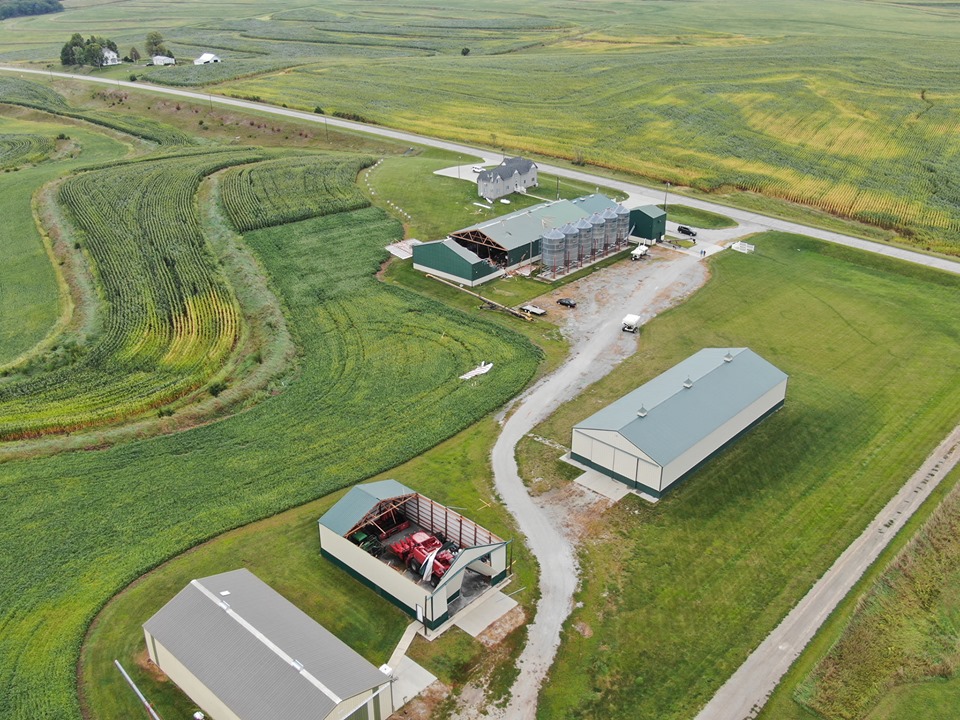
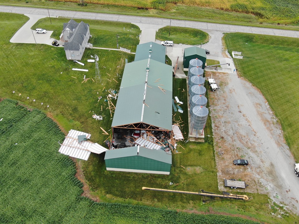
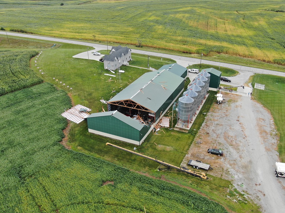
4:41-p.m. – Thunderstorm wind damage 5-mile W/NW of Hepburn in Page County. 120th & O Avenue in Page County, between Stanton and Bethesda…wind damage to 2 large metal buildings and various tree damage. (Reported by Emergency Mgmt.) See pics below…
2 miles S/SE of Clarinda: Thunderstorm wind gust est. at 51 mph (Automated Weather Obs. System)
4-p.m. – 4-to 6 inch diameter tree limbs down in Menlo, via EMA.

Storm damage between Hepburn & Stanton. (Photos by Montgomery County EMA)
Today: Areas of fog this morning; Mostly cloudy & windy w/rain. High 81. S @ 20-30 mph.
Tonight: Mostly cloudy & windy w/rain. Low 66. S @ 15-20.
Tomorrow: A chance of morning drizzle; Cloudy to P/Cldy. High 84. S @ 10-20.
Wednesday: Cldy to P/C, warm & humid. High 86. S @ 10-20.
Thursday: A chance of drizzle early; P/Sunny. High 83. SW @ 10-15.
Yesterday’s High in Atlantic was 71. Our Low was 63. We received .03″ rain yesterday at the KJAN studios. Last year on this date our High was 76 and the Low was 47. The record High in Atlantic on this date was 100 in 19893. The Record Low was 36 in 1959.
Today: Mostly cloudy, with a high near 76. East wind 6 to 8 mph.
Tonight: A 50 percent chance of showers and thunderstorms, mainly after midnight. Cloudy, with a low around 63. East wind 6 to 8 mph, with gusts as high as 18 mph. New rainfall amounts between a tenth and quarter of an inch, except higher amounts possible in thunderstorms.
Monday: A 40 percent chance of showers and thunderstorms, mainly after noon. Mostly cloudy, with a high near 80. Southeast wind 9 to 14 mph, with gusts as high as 26 mph. New rainfall amounts of less than a tenth of an inch, except higher amounts possible in thunderstorms.
Monday Night: A 30 percent chance of showers and thunderstorms. Mostly cloudy, with a low around 68. South wind 10 to 13 mph, with gusts as high as 26 mph. New rainfall amounts of less than a tenth of an inch, except higher amounts possible in thunderstorms.
Tuesday: A 20 percent chance of showers and thunderstorms. Partly sunny, with a high near 83. Southwest wind 8 to 10 mph, with gusts as high as 18 mph.
Tuesday Night: A 30 percent chance of showers and thunderstorms, mainly after 1am. Partly cloudy, with a low around 68.
Wednesday: A 20 percent chance of showers and thunderstorms. Mostly sunny, with a high near 86.
Saturday’s High in Atlantic was 66. Our Low 54. We received .28″ rain Saturday afternoon & late Saturday night. Last year on this date (Sept. 8th), the High in Atlantic was 76, and the Low was 47. The All-Time Record High was 100 in 1947, and 36 in 1986.
Skyscan Forecast Saturday, September 7, 2019 Austin Romer
Today: Rain in the morning, then remaining cloudy. SE @ 5. High 79.
Tonight: Rain showers. SE @ 5. Low 56.
Sunday: Rain in the morning, otherwise cloudy. E @ 10. High 76.
Monday: Light rain possible in the morning, then mostly cloudy. SE @ 15. High 84.
Tuesday: Light rain possible in the morning, then mostly cloudy. S @ 15. High 84.

Podcast: Play in new window | Download (636.2KB)
Subscribe: RSS
Today: Mostly sunny. High 80. N @ 10 mph.
Tonight: Clear to Partly cloudy. Low 61. N @ 10.
Tomorrow: Light rain in the morning & again overnight. High 79. E @ 5.
Sunday: Rain through early afternoon & again overight. High 69. E @ 15.
Monday: Rain in the morning & again overnight. High 82. SE @ 10-15.
Yesterday’s High in Atlantic was 86. Our Low 61. Last year on this date our High was 78 and the Low was 61. The record High in Atlantic on this date was 103 in 1939. The Record Low was 36 in 1962.
(Radio Iowa) — A new analysis from an Iowa City think tank suggests Iowa’s weather is hotter and wetter due to climate change. James Boulter, a chemistry professor at the University of Wisconsin-Eau Claire, reviewed weather data and prepared the report for the Iowa Policy Project. “Iowa is seeing, actually in a much clearer trend than most of the rest of the country…a significant increase in average annual rainfall,” Boulter says.
Boulter says the atmosphere is “amped up” and the conditions that led to the massive 1993 floods may become the “new normal.” He says “The idea is simply that as the Gulf of Mexico warms and you get increased evaporation, that can collide with this mid-latitude jet or this air mass that moves west to east across the United States,” Boulter says.
According to Boulter’s calculations, there’s been a five percent increase in average temperatures in Iowa over the past four decades and the amount of rain that fell in Iowa this spring shattered records set 116 years ago. Boulter says the data indicates there’s been an “uptick” in extreme or heavy rainfall events in Iowa and the upper Midwest over the last decade — causing billions of dollars in flood damage.
Today: Partly cloudy & humid. High 87. S @ 10 mph.
Tonight: Partly cloudy. Low 58. S @ 5.
Tomorrow: P/Cldy. High 81. N @ 10.
Saturday: Cloudy w/a chance of showers early & again late in the day. High 79. SE @ 10.
Sunday: Cldy w/scattered shwrs & tstrms early and late. High 77. E @ 10.
Yesterday’s High in Atlantic was 78. Our Low was 48. Last year on this date our High was 77 and the Low was 61. The record High in Atlantic on this date was 104 in 1913. The Record Low was 34 in 1962.
Today: Mostly sunny. High 78. N @ 10 mph.
Tonight: Partly cloudy. Low 59. SE @ 5.
Tomorrow: P/Cldy w/isolated showers & thunderstorms. High 85. S @ 10-20.
Friday: Mo. Sunny. High around 80.
Saturday: Mo. Cldy w/scattered shwrs & tstrms. High near 80.
Yesterday’s High in Atlantic was 86. Our Low this morning, 48. Last year on this date our High was 83 and the Low was 71. The record High in Atlantic on this date was 101 in 1918. The Record Low was 33 in 1891.


