
(Radio Iowa) — With forecasts calling for up to five inches of rain over three days this week, several counties in southwest Iowa are preparing for more Missouri River flooding. Michael Bertacini is an emergency management specialist with Pottawattamie County. He says around 40 homes are in the area of concern in the northwestern part of the county. “Most of those residents were actually out of their homes before this happened,” Bertacini says. “It’s just prolonging the effects of the flooding. These people have been flooded since March so it’s a bad deal for them because some people haven’t even been in their homes from March.”
Bertacini says it’s possible the impacts could mirror what the county saw this spring, though the river could crest about a foot lower. “All the county roads in the northwest part of the county on the west side of I-29 were basically underwater. I-680 and I-29 also went under,” he says. “It forces the water table to rise in Council Bluffs.”
Bertacini says people who live in Council Bluffs could see basement flooding if the storm sewers are not able to keep up with the heavy rainfall. In a joint news release, Pottawattamie, Harrison and Mills counties say it’s unclear where the heaviest rains will fall, so people should stay alert.
Weather statistics for the Month of September in Atlantic, show the month was much wetter, and slightly warmer than normal. Data compiled at the KJAN Studios (The official National Weather Service reporting station), show rainfall for the month, which is normally 3.81 inches, amounted to 8.82 inches, or nearly 5 inches above average. The average High last month was 81, which was about 5 degrees warmer than normal, and the average Low was 58, or about a little more than 7 degrees above normal. In October, we typically receive 2.76 inches of rain. The average High is 64.1, and the average Low is 39.
The National Weather Service in Des Moines says moderate to heavy rainfall is expected across the area today into tonight. Widespread 1 to 2 inches of rain can be expected north, with higher amounts of 1 to 3 inches across portions of central and southern Iowa. Some locations may receive 2-4 inches with isolated higher amounts possible. The heaviest rainfall is expected with strong storms expected to develop across central and southern Iowa this afternoon into tonight. The heavy rainfall may lead to flash flooding. Severe storms are also possible roughly along and south on I-80 across Iowa today into tonight. 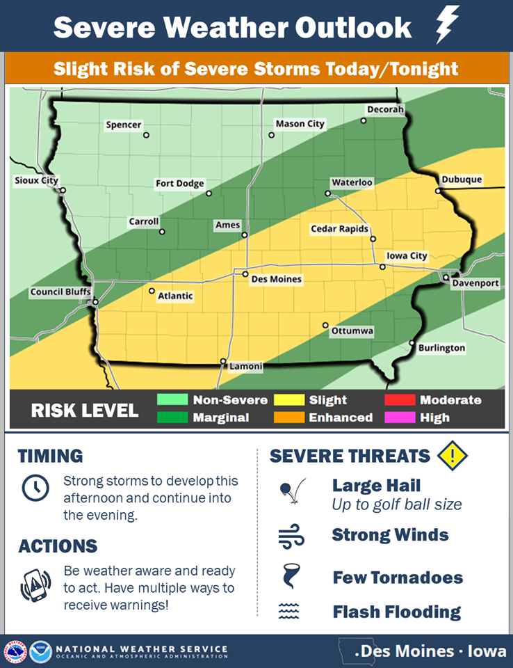
Strong to severe storms are expected to develop across portions of central and southern Iowa by this afternoon and continue into the evening. Large hail, damaging wind, a few tornadoes and flash flooding will all be possible. Please monitor the weather through the day for the latest on the severe storm and flash flood potential.
With the widespread rainfall expected through Wednesday, the potential exists for river flooding later this week. Main stem rivers may become bankfull or have the potential to go into minor flood later this week.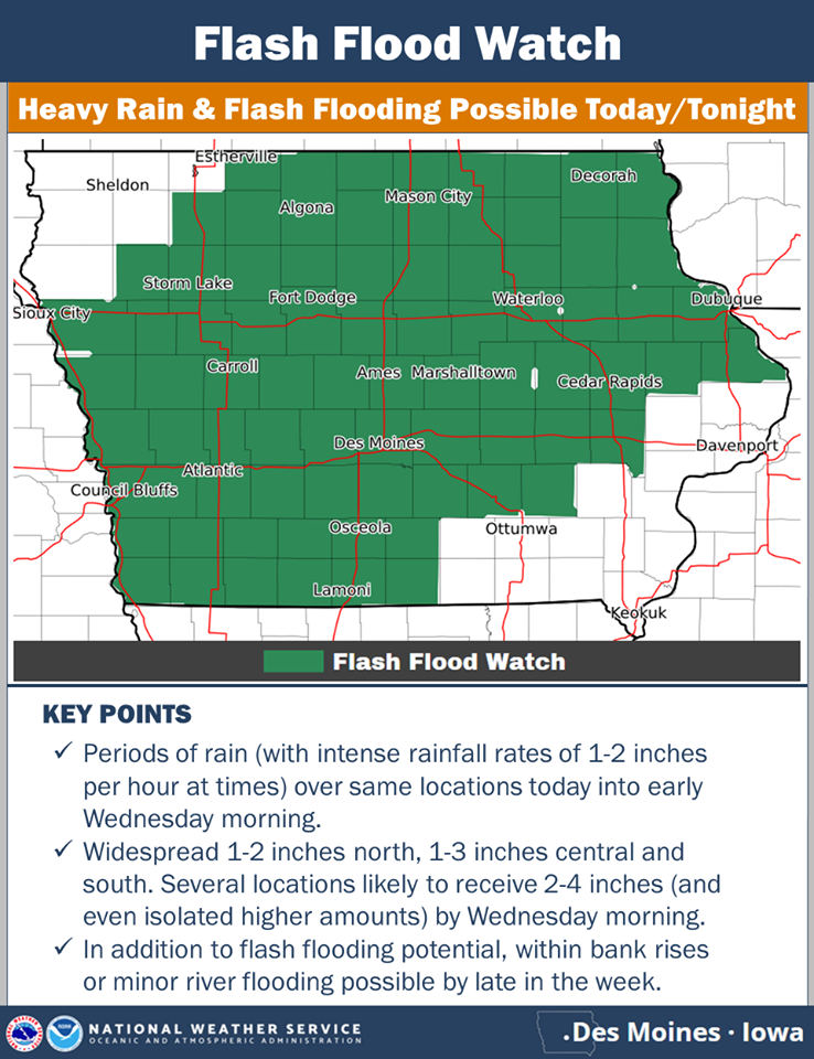
Today: Partly cloudy to cloudy w/scattered showers & thunderstorms. FLASH FLOOD WATCH in effect until 7-a.m. Wednesday. High 75. Variable winds @ 10-15 mph.
Tonight: Cloudy w/showers & thunderstorms, some heavy rain is likely. Low 54. N @ 5-10 mph.
Tomorrow: Mostly cloudy w/light rain or showers. High 63. N @ 10-15. Thursday: Partly cloudy. High around 63. Friday: Mo. Cldy w/showers late. High 65.
Monday’s High in Atlantic was 89. Our Low 73. Last year on this date our High was 55 and the Low was 49. The record High in Atlantic on this date was 96 in 1892. The Record Low was 23 in 1908 & 1984.
310 AM CDT Tue Oct 1 2019
…HEAVY RAIN AND FLASH FLOOD POTENTIAL TODAY INTO WEDNESDAY…
Widespread moderate to heavy rain is expected much of central Iowa today into early Wednesday. The rain has begin across northwest and north central Iowa early this morning, with the showers and storms expected to gradually spread southeast across Iowa today into tonight. Repeated rounds of rainfall may lead to widespread heavy rainfall totals and flash flooding. Many locations are already saturated from recent heavy rainfall over the past week. These wet soil conditions combined with increased runoff from post-mature croplands will increase the threat of flash flooding as well.
Sac-Crawford-Carroll-Audubon-Guthrie-Dallas-Cass-Adair-Adams-Taylor Counties…A FLASH FLOOD WATCH REMAINS IN EFFECT THROUGH WEDNESDAY MORNING…
* Widespread rainfall of 1 to 2 inches with areas of 2 to 3 inches expected. Locally heavier amounts in excess of 3 inches may occur by early Wednesday. Rain rates may exceed 1 to 2 inches per hour at times today into tonight.
* Low water crossings may become flooded, especially on secondary roads. Smaller streams may have rapid rises. Water may pond on roads and in fields. Urban areas may see significant ponding of water.
Madison-Union-Ringgold Counties…A FLASH FLOOD WATCH IS NOW IN EFFECT FROM 1 PM CDT THIS AFTERNOON THROUGH WEDNESDAY MORNING…Widespread rainfall of 1 to 2 inches with areas of 2 to 4 inches expected. Locally heavier amounts in excess of 4 inches may occur by early Wednesday. Rain rates may exceed 2 inches per hour at times this afternoon through tonight.
Monona-Harrison-Shelby-Pottawattamie-Mills-Montgomery-Fremont-
Page Counties...A FLASH FLOOD WATCH REMAINS IN EFFECT THROUGH WEDNESDAY MORNING…
* Multiple rounds of heavy rainfall producing storms will affect the area today into tonight, elevating the risk for flash flooding. Widespread rainfall amounts of 1 to 3 inches is likely with localized amounts up to 4 to 6 inches.
* Rapid rises of rivers, streams, and low water crossings could occur. Urbanized and poor drainage areas could be particularly impacted by floodwater. Roadways could become flooded.
PRECAUTIONARY/PREPAREDNESS ACTIONS…
A Flash Flood Watch means that conditions may develop that lead to flash flooding. Flash flooding is a VERY DANGEROUS SITUATION. You should monitor later forecasts and be prepared to take action
should Flash Flood Warnings be issued.
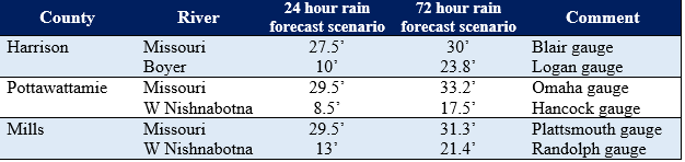
COUNCIL BLUFFS, Iowa – This (Monday) morning, the National Weather Service Missouri Basin River Forecast Center in Pleasant Hill, Missouri released forecast data which places the Missouri River and several tributary rivers back in higher levels of flood stage throughout Pottawattamie, Harrison & Mills counties. Many of the river forecasts are showing significant increases, primarily because the current modeling uses rain projections for the next 72 hours of potential precipitation. Typical models only account for 24 hours of projected rainfall.
Emergency Managers for the three counties, in consultation with the River Forecast Center, remind residents that the current projections should be viewed as one plausible scenario for the upcoming rainfall event. “What we do know is that over the next 72 hours we are going to see a heavy precipitation event of 4 to 5 inches of rain somewhere in the region; what we don’t know for certain is where it will fall,” commented Doug Reed, Director of Emergency Management for Pottawattamie County.
The current 72 hour rainfall predictions estimate a heavy band of rain, upwards of six inches, falling in a northeasterly line from near Columbus, NE through Onawa and Northwest Iowa. The heaviest rains in this system falling in this area would have a profound impact on the Missouri and some of its tributaries.
Emergency Managers urge residents to interpret the latest flood prediction in a measured manner based on the high degree of uncertainty of where the heaviest rains will fall. “We want people to be aware of the possibility of another round of significant flooding, but also aware that it is not certain we will see water at those levels until we get closer to the rain event,” commented Larry Hurst, Emergency Management Director for Mills County. “Residents should use all available information to take actions they feel necessary, keeping in mind that this forecast is certain to change as we enter the 72 hour window and have better forecast models to work from,” stated Larry Oliver, Harrison County Emergency Management/911 Director.
Below is a table of anticipated river levels based on a 24 hour prediction as well as the 72 hour prediction should the existing weather forecast have no changes over the next few days:
In addition to the river threats, emergency managers do want residents to recognize that we are expected to see in our counties a 2-3” rain event in already wet conditions. This could lead to interior flash flooding events along rural creeks and streams as well as urban flash flooding in municipal areas where drainage issues are typical.
All residents are encouraged to pay close attention to updated rain and river forecasts this week. Forecast details and river predictions will be changing through the next few days. Residents in all three counties can sign up for weather alerts and local emergency notifications below:
Pottawattamie County Pottawattamie Alert https://entry.inspironlogistics.com/pottawattamie_ia/wens.cfm Harrison County Citizen Alert System https://member.everbridge.net/index/892807736721501#/login Mills County Mills Alert https://entry.inspironlogistics.com/Mills_ia/wens.cfm
National Weather Service Des Moines IA
403 AM CDT Mon Sep 30 2019
…HEAVY RAIN AND FLASH FLOOD POTENTIAL…
A wet pattern is setting up across portions of Iowa through midweek. Repeated rounds of rainfall are expected which may lead to widespread heavy rainfall and the potential for flash flooding. Some areas of the state have already had heavy rainfall over the past several days to a week with soils already saturated in spots. These conditions combined with increased runoff from post-mature croplands will increase the threat of flash flooding as well.
Sac-Crawford-Carroll-Audubon-Guthrie-Dallas-Cass-Adair-Adams-Taylor Counties – FLASH FLOOD WATCH 10-P.M. (9/30) THRU 7-A.M. WEDNESDAY (10/2)
Monona-Harrison-Shelby-Pottawattamie-Mills-Montgomery-Fremont-Page-Counties – FLASH FLOOD WATCH 7-P.M. (9/30) THRU 7-A.M. WEDNESDAY. (10/2)
* Widespread rainfall of 1 to 2 inches with areas of 2 to 4 inches expected. Locally heavier amounts in excess of 4 inches possible through early Wednesday. Rain rates may exceed 1 to 2inches per hour at times late tonight through Tuesday night.
* Low water crossings may become impeded, especially on secondary roads. Smaller streams may have rapid rises. Water may pond on roads and in fields. Urban areas may see ponding of water.
PRECAUTIONARY/PREPAREDNESS ACTIONS…
A Flash Flood Watch means that conditions may develop that lead to flash flooding. Flash flooding is a VERY DANGEROUS SITUATION. You should monitor later forecasts and be prepared to take action should Flash Flood Warnings be issued.
Today: Partly cloudy & windy. High 86. SW @ 15-30 mph.
Tonight: P/Cldy to Cloudy w/scattered showers & thunderstorms. Low 70. S @ 10 mph.**Flood Watch in effect from 10-p.m. (9/30) thru 7-a.m. Wednesday (10/2)**
Tuesday: P/Cldy to Cldy w/scattered shwrs & tstrms. High 78. S @ 10-15.
Wednesday: Mostly cloudy w/rain. High near 65. Thursday: P/Cldy. High 65.
Sunday’s High in Atlantic was 75. Our Low 61. We received .18” rain, Sunday. Last year on this date our High was 51 and the Low was 48. The record High in Atlantic on this date was 92 in 1994. The Record Low was 21 in 1984.
Summer isn’t quite done yet! The National Weather Service in Des Moines says unseasonably warm and muggy weather will set in from later tonight through Monday night. High temperatures on Monday afternoon will range well into the 80s, combining with dewpoints in the low to mid-70s to push heat index values over 90 degrees in most areas.
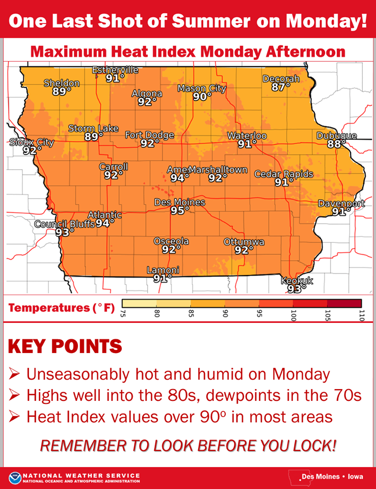
click to enlarge the graphic
Officials advise you to take appropriate precautions if engaging in outdoor physical activity.


