
Guthrie-Dallas-Cass-Adair-Madison-Adams-Union-Taylor-Ringgold Counties: WIND ADVISORY REMAINS IN EFFECT UNTIL NOON CST TODAY. And, until 9-a.m. for Montgomery-Fremont and Page Counties. Northwest winds 20 to 30 mph with gusts up to 45 mph can be expected.
Gusty winds could blow around unsecured objects such as holiday decorations. Tree limbs could be blown down and a few power outages may result.
PRECAUTIONARY/PREPAREDNESS ACTIONS…
Use extra caution when driving, especially if operating a high profile vehicle. Secure outdoor objects.
(Radio Iowa) — Travel conditions are expected to deteriorate as a winter storm approaches the state. State Patrol Trooper Tom Williams of Mason City says if you do plan to travel, pack a winter survival kit in case something happens. “Things that are important to have in a vehicle include an ice scraper, cell phone and charger, blankets, gloves, hats, an extra coat, water, non-perishable food items, a shovel, kitty litter for traction, a set of jumper cables, any needed medication, and a tow strap,” according to Williams.
He says if you do get stranded — it’s important to take quick action. “Call 9-1-1 immediately and give your location. Stay in your vehicle, that’s your shelter, don’t try to walk for help,” Williams says. “If it’s at night, keep your dome light on if possible. Make sure your exhaust pipe is clear from snow. Run your engine and heater just long enough to remove the chill, so you can conserve gas.”
He says it’s important to not delay in calling 9-1-1 as law enforcement is going to be busy. Williams says its important at any time this winter to be well prepared for your trip. You should leave early if the weather report shows things are going to get bad. “Get plenty of rest the night before. Slow down to increase the control of your vehicle. You are required by law to maintain control at all times. Allow at least five seconds of following distance from the vehicle that’s in front of you,” Williams says. “Make sure all your lights are working, that you have good wiper blades and washer fluids, make sure that you have a good set of snow tires on.”
Williams says don’t get over confident simply because you have a four-wheel-drive vehicle. “Those of you who have four-wheel-drive or all-wheel-drive vehicles, that does not improve you’re breaking ability,” he says. “It allows for excellent traction, but it does not improve your ability to stop in emergency situations.” You can check out road conditions 24 hours a day online at the D-O-T’s 5-1-1 travel.
Today: Cloudy w/rain late this morning & this afternoon. High 38. E @ 15-25.
Tonight: Cloudy w/rain changing to snow. Low 29. N @ 15-30.
Tomorrow: Wind Advisory from 3-a.m. Until Noon; Mo. Cldy w/Light snow early. (1-2” total). Becoming P/Cldy in the afternoon. High 33. NW @ 20-40.
Thursday (Thanksgiving Day): Mostly cloudy w/light mixed precip in the afternoon. High 34.
Friday: Mo. Cldy w/rain. High 46.
Monday’s High in Atlantic was 54. Our Low, 27. Last year on this date, the High in Atlantic was 28 and the Low was 8. The record High for Nov. 26th in Atlantic, was 69 in 1990. The Record Low was -9 in 1898.
A WINTER WEATHER ADVISORY REMAINS IN EFFECT FROM NOON TODAY (TUESDAY) UNTIL 9-A.M. WEDNESDAY, FOR Shelby, Harrison and Pottawattamie Counties, and from 6-P.M. TODAY UNTIL NOON WEDNESDAY, for Audubon and Carroll Counties. Mixed precipitation expected. Total snow accumulations of 1 to 5 inches and ice accumulations up to one tenth of an inch are possible from Denison and Carroll toward north central Iowa. Winds will be gusting as high as 40-to 50-mph.
Plan on slippery road conditions. The hazardous conditions could impact the morning or evening commute. A rain and a mixture snow, and sleet is forecast to turn over to all snow on Tuesday afternoon and evening. The heaviest snowfall is expected after 6 PM. Slow down and use caution while traveling. Areas of blowing snow could significantly reduce visibility with near blizzard conditions. The hazardous conditions could impact this evening`s and tomorrow morning`s commute. Gusty winds could bring down tree branches with isolated power outages.
A WINTER STORM WARNING remains in effect from 6-p.m. today (Tuesday) until Noon Wednesday, for Sac and Crawford Counties, and from 9-a.m. today until 9-a.m. Wednesday for Monona County. Moderate to heavy Snow and strong north to northwest winds. Near Blizzard conditions are expected in far northern Iowa. Total snow accumulations of 5 to 10 inches are possible, with the highest amounts will be near the Minnesota border. Winds gusting from 35 to 45 mph with a few of up to 50 mph.
Travel is likely to become very difficult with significant blowing snow reducing visibility and even leading to near blizzard conditions at times. In addition, slick and snow covered roads will lead to treacherous traveling conditions. If you must travel, keep an extra flashlight, food, and water in your vehicle in case of an emergency. For the latest road conditions, dial 5-1-1 for the State you are traveling in. In Iowa, you can also go to 511ia.org, on the web.
The National Weather Service has issued a WIND ADVISORY for Guthrie-Dallas-Cass-Adair-Madison-Adams-Union-Taylor and Ringgold Counties, from 3-a.m. Wednesday, until Noon. And from 9-p.m. tonight (Tuesday) through 9-a.m. Wednesday, for Mills-Montgomery-Fremont and Page Counties, where areas of rain may mix with or change to light snow. This will create some areas of blowing snow however little to no snow accumulation is expected in the wind advisory area.
Northwest winds 25 to 35 mph with gusts up to 50 mph are expected. Peak winds around daybreak Wednesday. Gusty winds could blow around unsecured objects. Tree limbs could be blown down. Use extra caution when driving, especially if operating a high profile vehicle. Secure outdoor objects
A WINTER ADVISORY IS IN EFFECT FROM NOON TUESDAY UNTIL 9-A.M. WEDNESDAY, FOR Shelby, Harrison and Pottawattamie Counties, and from 6-P.M. TUESDAY UNTIL NOON WEDNESDAY, for Audubon and Carroll Counties. Total snow accumulations of 2 to 4 inches is possible in the ADVISORY area, along with winds gusting as high as 40 mph.
Plan on slippery road conditions. The hazardous conditions could impact the morning or evening commute. A rain and a mixture snow, and sleet is forecast to turn over to all snow on Tuesday afternoon and evening. The heaviest snowfall is expected after 6 PM. Slow down and use caution while traveling.
A WINTER STORM WARNING is in effect from 6-p.m. Tuesday until Noon Wednesday, for Sac and Crawford Counties, and from 9-a.m. Tuesday until 9-a.m. Wednesday for Monona County. Moderate to heavy Snow and strong north to northwest winds. Near Blizzard conditions are expected in far northern Iowa. Total snow accumulations of 4 to 8 inches. Highest amounts will be near the Minnesota border. Winds gusting from 35 to 45 mph with a few of up to 50 mph.
Travel is likely to become very difficult with significant blowing snow reducing visibility and even leading
to near blizzard conditions at times. In addition, slick and snow covered roads will lead to treacherous traveling conditions. If you must travel, keep an extra flashlight, food, and water in your vehicle in case of an emergency.
For the latest road conditions, dial 5-1-1 for the State you are traveling in. In Iowa, you can also go to 511ia.org, on the web.
WINTER STORM WATCH (UPDATED 11/25) —
Harrison and Monona Counties: WINTER STORM WATCH IN EFFECT FROM 9-A.M. TUESDAY THROUGH 9-A.M. WEDNESDAY.
* WHAT…Heavy snow possible. Total snow accumulations of 3 to 6 inches possible. Winds could gust as high as 40 mph.
* IMPACTS…Plan on slippery road conditions. Patchy blowing snow could significantly reduce visibility. The hazardous conditions could impact the morning or evening commute.
Sac-Crawford and Carroll Counties: A WINTER STORM WATCH REMAINS IN EFFECT FROM 6-P.M. TUESDAY UNTIL NOON WEDNESDAY.
* WHAT…Moderate to Heavy snow with blustery winds. Near blizzard conditions possible. Total snow accumulations of 3 to 8 inches are forecast with the highest amounts anticipated near the Minnesota border. Wind gusts between 35 to 45 mph are likelywith potentially a few gusts nearing 50 mph.
* IMPACTS…Travel is likely to become very difficult with significant blowing snow reducing visibility and even leading to near blizzard conditions at times. In addition, slick and snow covered roads will lead to treacherous traveling conditions.
* ADDITIONAL DETAILS…Those with Thanksgiving travel plans Tuesday night through Wednesday should take the necessary precautions and potentially find alternate routes or delay or move up travel plans if possible. If you must travel during the
storm, please remember to pack a winter survival kit in your vehicle in case you become stranded.
Today: Partly cloudy. High 53. NW @ 10-20.
Tonight: P/Cldy to Cloudy. Low 32. E @ 5-10.
Tomorrow: Mostly cloudy w/rain. High 38. E @ 15-25.
Tom. Night: Rain changing to snow. Freezing rain possible toward sunrise, & patchy blowing snow. Low 26. N/NE winds becoming NW @ 20- to 40 mph. Little or no ice accumulation expected. New snow accumulation of 1 to 2 inches possible.
Wednesday: Cldy w/light snow & blowing snow in the morning. High 32.
Thanksgiving Day: Cldy w/light rain in the afternoon. High 36.
Sunday’s High in Atlantic was 57. Our Low this morning was 26. Last year on this date, the High in Atlantic was 29 and the Low was 14. The record High for Nov. 25th in Atlantic, was 71 in 1960. The Record Low was -6 in 1991.
Area Counties: Sac-Crawford-Carroll…WINTER STORM WATCH IN EFFECT FROM 6-P.M. TUESDAY until NOON WEDNESDAY
* WHAT…Heavy snow possible along with strong winds. Total snow accumulations of 4 to 8 inches possible. Highest amounts expected near the Minnesota border. Winds could gust of 35 to 45 mph will be possible.
* IMPACTS…Travel could be very difficult. Areas of blowing snow could significantly reduce visibility. The hazardous conditions could impact the morning or evening commute.
* ADDITIONAL DETAILS…Near blizzard conditions may exist early Wednesday morning from the combination of falling snow and strong north winds. Be prepared very poor conditions early
Wednesday morning in the watch area.
PRECAUTIONARY/PREPAREDNESS ACTIONS…
Monitor the latest forecasts for updates on this situation.
The National Weather Service in Johnston says moderate snow is forecast to develop over portions of west-central to northern Iowa during the afternoon hours Tuesday and continue into early Wednesday morning. The greatest snowfall rates are likely to occur Tuesday evening. A rain/snow line is likely to set up from Waterloo to Des Moines to southwest portions of Iowa.
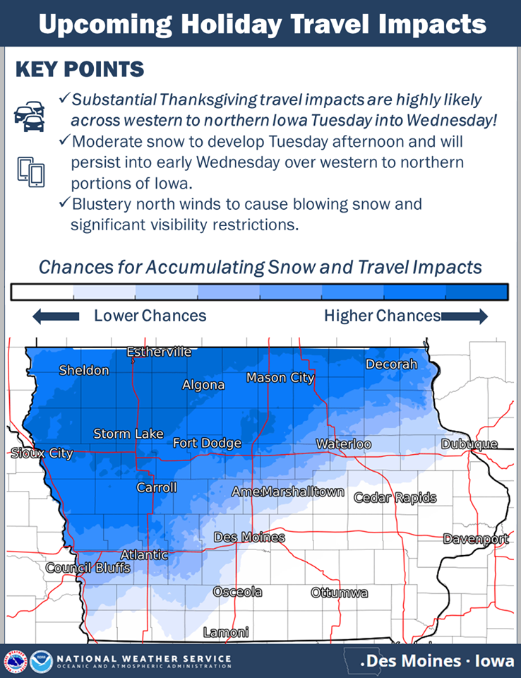
click to enlarge the graphic
Anything northwest of that line is likely to receive the accumulating snow. In addition to the snow, north winds of 25 to 35 mph are likely by Tuesday night and look to persist throughout the day Wednesday resulting in blowing snow and visibility restrictions. Hazardous travel is anticipated due to snow covered and slick roads along with the visibility restrictions.
If traveling Tuesday into Wednesday over portions of western and northern Iowa into Minnesota, please consider rescheduling.


