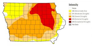
(Iowa Capital Dispatch) – Iowa’s long-running drought has eased since a month ago but is still by far the worst it’s been leading into the growing season in the past three years, according to the U.S. Drought Monitor. The area of the state that is suffering from extreme drought — the second-worst classification of the Drought Monitor — is about half what it was in December but still encompasses a vast area of northeast Iowa. That includes some or all of more than two dozen counties.
About three-quarters of the state has some measure of drought. The exceptions are a wide area of northwest Iowa and parts of far southern and far eastern Iowa. Drought conditions have persisted in the state since July 2020 — the longest stretch since the 1950s, according to the Iowa Department of Natural Resources. The dryness peaked in September 2023.
Many Iowa rivers have very low flow, according to U.S. Geological Survey data. In Osceola, residents have been urged to conserve water as the town’s water supply — West Lake — has dwindled. But the city reported early this month that the lake’s level had stabilized.

The area of extreme drought in Iowa has shrunk considerably in the past month. (Courtesy of U.S. Drought Monitor)
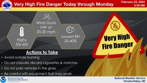
(Omaha/Valley, NE) – The National Weather Service in Omaha says the warm weather we’ve been experiencing the past few days in southeastern Nebraska and Southwestern Iowa, is here to stay through the weekend. The Weather Service said also, a “Very high fire danger will persist for the next few days.”
In the Hazardous Weather Outlook issued by the NWS in Des Moines, officials said dry and breezy conditions will lead to potential very high fire danger conditions in at least a portion of the area each day. The highest potential may be in southeast Nebraska on Monday, where some areas may see extreme fire danger.
The Iowa Department of Public Safety reports only Harrison County in our listening area, has a Burn Ban in place. That order was issued in late September, 2023, and remains in effect until further notice.
(Radio Iowa) – Hopes raised in January for a turnaround in the state drought situation went away as February turned dry. Iowa D-N-R Hydrologist, Tim Hall says the latest Drought Monitor Report shows that. “There’s a significant chunk of the state of Iowa right, now about almost 20 percent of the state that’s rated by the drought monitor as extreme drought in northeast Iowa,” Hall says. He says that runs from Linn and Benton County north all the way up to the Minnesota border. And 56 percent of the state is rated in severe drought.
“In the wintertime when nothing’s growing and we don’t think about water use, it’s kind of easy to stop remembering where we are. But we still have more than half of the state rated in severe drought. And that’s a problem moving into the spring months and the growing season,” Hall says. He says the January snow was good, but when it melted in February, it illustrated how dry things are. “We had two feet of snow in the state over large parts of the state, and it all melted fairly quickly, and we saw zero instances of flooding,” Hall says. “And that just tells me that the soils are so incredibly dry.”
Hall says the dry soil sucked up most of the snow melt and there was not a lot left to refill empty streams and rivers. “To have that amount of snow melt off and have no even localized flooding is a very surprising thing,” he says. The snow came in January which was one inch above normal for precipitation. But Hall says all that surplus has gone away in what may end up being the driest February on record. “So the pattern of wet month, dry month, wet month, dry month, that doesn’t help us much. We need wet month, wet month, wet month, wet month,” Hall says.
He says we typically get a lot more rain in the spring months, and we’ll need that to work toward getting rid of the drought.
Today: Partly cloudy to cloudy, & windy. High near 53. West winds @ 10-20 mph w/gusts to near 30.
Tonight: Mostly cloudy early, then gradually becoming clear. Low around 23. N/NW @ 10-20.
Tomorrow: Sunny & breezy. High near 58. S/SW @ 10-20.
Tom. Night: Clear, with a low around 32.
Sunday: Sunny, with a high near 63.
Monday: Sunny & breezy, with a high near 73.
Tuesday: Mostly sunny & windy, with a high near 62.
Thursday’s High in Atlantic was 66. The Low was 24. Last year on this date, the High in Atlantic was 19 and the Low was 1. The Record High for Feb. 23rd was 65 degrees, set in 2022. The Record Low was -22, in 1989.
Todday: Mostly cloudy & breezy through mid morning, then gradual clearing. High near 60. N/NW winds @ 10-20 w/gusts to around 25 mph.
Tonight: Mostly clear. Low around 32. NW winds @ 10-20 mph.
Friday: Mostly sunny & breezy. High near 50. NW @ 10-25 mph.
Friday Night: Mostly clear, with a low around 23.
Saturday: Sunny, with a high near 56. Breezy.
Sunday: Sunny, with a high near 63.
Wednesday’s High in Atlantic was 68, which broke the record of 66 set in 2017. Our Low was 29. Last year on this date (2/22), the High in Atlantic was 32 and the Low was 9. The Record High was 71 in 2017, and the Record Low was -14 in 1894. Sunrise is at 7:06-a.m. Sunset will be at 6:02-p.m.
Today: Partly sunny, with a high near 64. E winds @ 5-10 mph.
Tonight: Mostly cloudy, with a low around 40. N/NW wind 5 to 10 mph.
Tomorrow: Mostly sunny & breezy. High near 56. N @ 10-20 mph.
Tom.Night: Mostly clear, with a low around 29.
Friday: Sunny, with a high near 49.
Saturday: Sunny, with a high near 58.
Sunday: Sunny, with a high near 64.
Tuesday’s High in Atlantic was 65, which tied the record for Feb. 20th set in 1925. Our Low was 18. Last year on this date (2/21), the High in Atlantic was 44 and the Low was 21. The Record High was 66 in 2017, and the Record Low was -19 in 1894. Sunrise is at 7:07-a.m. Sunset will be at 6-p.m.
Today: Sunny, with a high near 61. S/SW winds 10-20 mph.
Tonight: Mostly clear, with a low around 31. South wind 5 to 10 mph becoming west after midnight.
Wednesday: Partly sunny, with a high near 61. Light and variable wind becoming east 5 to 10 mph in the morning.
Wednesday Night: Mostly cloudy, with a low around 38. E/NE @ 5-10 becoming north after midnight.
Thursday: Mostly sunny & breezy, with a high near 53.
Thursday Night: Mostly clear, with a low around 30.
Friday: Sunny, with a high near 52. Breezy.
Monday’s High in Atlantic was 58. The Low was 17. Last year on this date, the High in Atlantic was 49 and the Low was 21. The Record High for Feb. 20th in Atlantic, was 65 in 1925. The Record Low was -19, in 1978. Sunrise today: 7:08. Sunset: 5:59.
Today (President’s Day): Sunny & breezy. High near 53. S @ 10-20. Wind chill values as low as 10 early.
Tonight: Mostly clear, with a low around 23.
Tuesday: Sunny, with a high near 58. Southwest wind 5 to 10 mph.
Wednesday: Partly sunny, with a high near 59.
Thursday: Mostly sunny & breezy, with a high near 53.
Sunday’s High in Atlantic was 48. The Low was 16. Last year on this date, the High in Atlantic was 46 and the Low was 24. The Record High for Feb. 19th in Atlantic, was 71 in 2017. The Record Low was -22, in 1936. Sunrise today: 7:09. Sunset: 5:58.
Today: Sunny, with a high near 43. Winds NW @ 5-10 mph. Wind chill values as low as 10.
Tonight: Mostly clear, with a low around 24.
Monday (Washington’s Birthday): Mostly sunny, with a high near 51. S/SE winds @ 10-20 becoming westerly in the afternoon.
Tuesday: Sunny, with a high near 55. W/NW @ 5-10 becoming southerly in the afternoon.
Wednesday: Mostly sunny, with a high near 61.
Thursday: Partly sunny & breezy, with a high near 53.
Saturday’s High in Atlantic was 34. The Low was 8. Last year on this date, the High in Atlantic was 46 and the Low was 24. The Record High for Feb. 18th in Atlantic, was 67 in 2017. The Record Low was -25, in 1978. Sunrise today: 7:12. Sunset: 5:56.
Today: Sunny & breezy. High near 34. West winds @ 10-25 mph. Wind chill values as low as -5.
Tonight: Clear, with a low around 21. W/SW @ 10-20 mph.
Tomorrow: Sunny, with a high near 46. West wind 5 to 10 mph.
Tom. Night: Mostly clear, with a low around 23. W/SW @ 5-10 becoming S/SE.
Monday (Washington’s Birthday): Mostly sunny, with a high near 51.
Monday Night: Partly cloudy, with a low around 24.
Tuesday: Mostly sunny, with a high near 54.
Friday’s High in Atlantic was 30. The Low was 4. We received a Trace of snowfall between 7-a.m. Friday and 7-a.m. today, at KJAN. Last year on this date, the High in Atlantic was 32 and the Low was -9. The Record High for Feb. 17th in Atlantic, was 71 in 2017. The Record Low was -34, in 1958. Sunrise today: 7:13. Sunset: 5:56.