


Winter storm “Phase 1” to begin this evening
February 22nd, 2019 by Ric Hanson
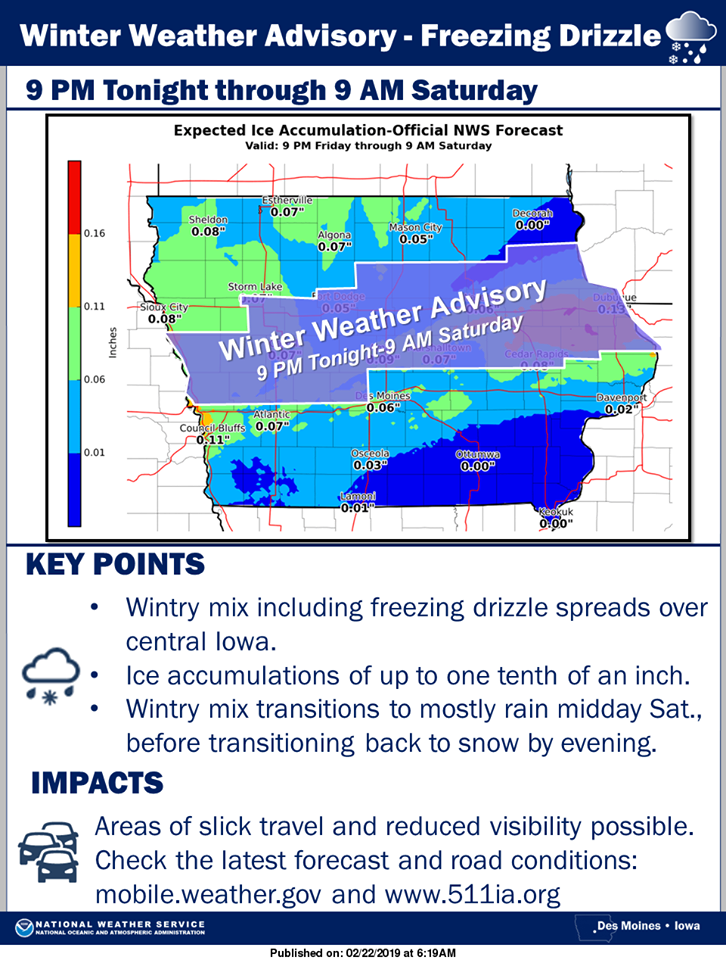
The National Weather Service says “Phase #1 of a very potent storm system will bring a round of freezing drizzle to central and northern Iowa this evening through Saturday morning.” Ice accumulation of up to one tenth of an inch is expected. A Winter Weather Advisory has been issued for the central section of Iowa. This will likely make for difficult travel this evening through Saturday Morning. Please be careful in traveling.
 Here’s a reminder of the current Winter Weather Watches & Advisories…
Monona-Harrison-Shelby-Pottawattamie Counties……WINTER WEATHER ADVISORY IN EFFECT FROM 4 PM TODAY THROUGH NOON SATURDAY…...WINTER STORM WATCH REMAINS IN EFFECT FROM NOON SATURDAY AFTERNOON THROUGH 6-PM SUNDAY…Mixed precipitation.Blizzard conditions possible. Total snow accumulations of up to one inch and ice accumulations of around one tenth of an inch expected. Total snow accumulations of 3 to 6 inches and ice accumulations of a light glaze possible. Winds could gust as high as 45 mph.
Audubon-Guthrie-Dallas Counties…WINTER WEATHER ADVISORY IN EFFECT FROM 9 PM TODAY (FRIDAY) THROUGH 9-A.M. SATURDAY. .WINTER STORM WATCH REMAINS IN EFFECT FROM 6-P.M. SATURDAY THROUGH 6-P.M. SUNDAY. Mixed precipitation expected tonight through Sunday morning. Blizzard conditions possible Saturday evening into Sunday. Ice accumulations of up to one tenth of an inch
possible. Total snow accumulations of 3 to 5 inches possible. Winds could gust as high as 50 mph.
Cass-Adair-Madison-Adams-Union-Taylor-Ringgold Counties….WINTER STORM WATCH REMAINS IN EFFECT FROM 6-PM SATURDAY THROUGH 6-PM SUNDAY…Blizzard conditions possible. Total snow accumulations of 2 to 4 inches possible. Winds could gust as high as 45 mph. Plan on slippery road conditions. Areas of blowing snow could significantly reduce visibility.
Mills-Montgomery-Fremont-Page Counties……WINTER STORM WATCH REMAINS IN EFFECT FROM NOON SATURDAY UNTIL 6-P.M. SUNDAY. Blizzard conditions possible. Total snow accumulations of 2 to 8 inches and ice accumulations of a light glaze possible. Winds could gust as high as 35 to 55 mph. Near zero whiteout conditions.
PRECAUTIONARY/PREPAREDNESS ACTIONS…
A Winter Storm Watch for blizzard conditions means there is a potential for falling and/or blowing snow with strong winds and extremely poor visibilities. This can lead to whiteout conditions and make travel very dangerous. A Winter Weather Advisory means that periods of snow, sleet or freezing rain will cause travel difficulties. Expect slippery roads and limited visibilities, and use caution while driving.
