


Winter Storm Watch issued for the KJAN listening area: Sat. night thru Sun. night
November 23rd, 2018 by Ric Hanson
…Winter Storm to Impact Portions of Iowa This Weekend…
The National Weather Service says a winter storm is expected to impact portions of central and southern Iowa Saturday night into Sunday evening. This system will bring the potential for moderate to heavy snowfall and strong winds that may result in significant blowing snow. These conditions may lead to very difficult travel conditions.
330 AM CST Fri Nov 23 2018
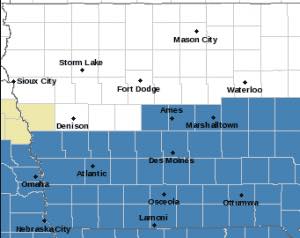
Winter Storm Watch from 12-a.m. Sunday through 12-a.m. Monday for Counties in blue.
A WINTER STORM WATCH IS IN EFFECT FROM LATE SATURDAY NIGHT THROUGH
SUNDAY EVENING for ALL COUNTIES IN THE KJAN LISTENING AREA (Cass, Adair, Adams, Audubon, Carroll, Crawford, Dallas, Guthrie, Fremont, Harrison, Mills, Montgomery, Page, Pottawattamie, Ringgold, Shelby, Taylor and Union. **For most counties, the Watch is in effect from 12-a.m. Sunday until 12-a.m. Monday, but for the far western counties it is in effect from 12-a.m. Sunday until 6-p.m.**
* WHAT…Moderate to heavy snow possible. Total snow accumulations of 3 to 8 inches possible with the heaviest amounts over southern Iowa. Winds gusts in excess of 40 mph possible.
* ADDITIONAL DETAILS…Travel could be very difficult. Blowing snow could significantly reduce visibility.
PRECAUTIONARY/PREPAREDNESS ACTIONS…
A Winter Storm Watch means there is potential for significant snow, sleet or ice accumulations that may impact travel. Continue to monitor the latest forecasts.

