


Wind Advisory for the western third of Iowa Monday
October 22nd, 2017 by Ric Hanson
Counties: Monona-Harrison-Shelby-Pottawattamie-Mills-Montgomery-Fremont-Page
WIND ADVISORY IN EFFECT FROM 10 AM TO 7 PM CDT MONDAY, OCT. 23rd
Counties: Emmet-Palo Alto-Pocahontas-Sac-Calhoun-Crawford-Carroll-Audubon-Cass:
WIND ADVISORY IN EFFECT FROM 1 PM TO 7 PM CDT MONDAY, OCT, 23RD
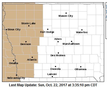
Wind Advisory counties in tan
The National Weather Service in Des Moines has issued a Wind Advisory.
* TIMING…Winds will become northwest and quite gusty by midday, continuing through sunset.
* WINDS…Northwest winds will reach sustained speeds of 25 to 35 mph with peak gusts of 40 to 45 mph. Winds will gust to near 50 mph Monday afternoon in the far west & southwest counties.
* IMPACTS…Strong northwest winds may affect high profile vehicles, blow trash cans and other loose objects and break small branches. These strong winds may also cause difficulty controlling fires with fields being harvested especially susceptible.
PRECAUTIONARY/PREPAREDNESS ACTIONS…
A Wind Advisory means that winds of 30 mph or more are expected. Winds this strong can make driving difficult, especially for high
profile vehicles. Use extra caution.

