


UPDATE! FLASH FLOOD WATCH EXPANDED
October 6th, 2017 by Ric Hanson
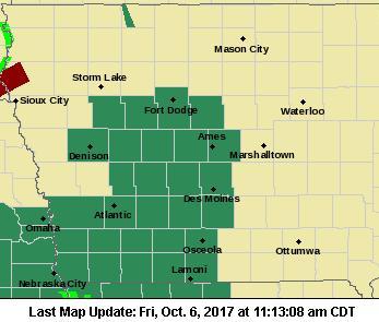
THE NATIONAL WEATHER SERVICE HAS EXTENDED A FLASH FLOOD WATCH TO COUNTIES NORTH OF INTERSTATE 80 THRU 7-A.M. SATURDAY. The FLASH FLOOD WATCH now includes the Counties of Audubon, Guthrie, Dallas, Sac, Crawford and Carroll in the KJAN listening area. That’s in addition to the previouslyt mentioned counties of Cass, Adair, Adams, Madison, Ringgold, Taylor and Union.
* Widespread rainfall amounts of 1 to 3 inches of rain can be expected through Saturday morning, with locally higher amounts in excess of 3 inches possible.
* Heavy rainfall may lead to rapid rises on local creeks and streams and ponding of water on roadways.
 PRECAUTIONARY/PREPAREDNESS ACTIONS…
A Flash Flood Watch means that conditions may develop that lead to flash flooding. Flash flooding is a VERY DANGEROUS SITUATION. You should monitor later forecasts and be prepared to take action should Flash Flood Warnings be issued.
Remember also, A FLOOD WATCH continues until 5-a.m. Saturday for Pottawattamie-Mills-Montgomery-Fremont-Page Counties. Occasional rounds of showers and thunderstorms with heavy rainfall potential are expected through tonight. Additional rainfall of 1 to 3 inches are possible, which would put storm total rains from Thursday through tonight in the 2.5 to 5 inch range. Flooding of low-lying area, urban areas and eventually rivers and streams could result.

