


Flash Flood Watch/Flood Watch Update
October 6th, 2017 by Ric Hanson
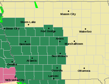
A FLASH FLOOD WATCH remains in effect until 7-a.m. Saturday for the following counties in Western Iowa: Sac-Crawford-Carroll-Greene-Audubon-Guthrie-Dallas-Cass-Adair-Madison-Adams-Union-Taylor-Ringgold.
A FLOOD WATCH remains in effect until 5-a.m. Saturday for these counties: Harrison-Shelby-Pottawattamie-Mills-Montgomery-Fremont-Page.
 FLOOD WATCH details: Occasional rounds of showers and thunderstorms with heavy rain potential are expected through tonight. Additional amounts of 1 to 3 inches are possible, which would put storm total rains from Thursday through tonight in the 2 to 6 inch range. Flooding of low-lying area, urban areas and eventually rivers and streams could result.
* In addition to the general flood threat, faster or flash flooding, could occur with some storms that may develop through this evening in southeast Nebraska and southwest Iowa.
FLASH FLOOD WATCH details: Widespread rainfall amounts of 1 to 3 inches of rain can be expected through Saturday morning, with locally higher amounts in excess of 3 inches likely. Rainfall rates will be heavy at times with the potential for rainfall amounts of 2 inches occurring in an hour or less.
* Heavy rainfall may lead to rapid rises on local creeks and streams which may be high enough to cross roadways, especially low lying areas. Significant ponding of water on roadways is expected at times as well. Flash flooding at night is extremely dangerous and drivers should turn around if they come to an area where water is flowing over the road.
PRECAUTIONARY/PREPAREDNESS ACTIONS…
A Flash Flood Watch means that conditions may develop that lead to flash flooding. Flash flooding is a VERY DANGEROUS SITUATION. You should monitor later forecasts and be prepared to take action should Flash Flood Warnings be issued.

