


Winter Storm Warning expanded to most of Iowa
January 31st, 2015 by Ric Hanson
The National Weather Service has expanded the WINTER STORM WARNING for parts of southern and central Iowa to include most of the state. The Warning is in effect from 6-pm Sat. (1/31) until 9-pm Sunday (2/1), for Monona-Harrison-Shelby and Pottawattamie Counties in the KJAN listening area, and from 7-pm Sat. thru 9-pm Sunday for Cass, Adair, Adams, Audubon, Guthrie, Dallas, Sac, Crawford, Carroll, Ringgold, Taylor and Union Counties. In the warned area, 7-to 10-inches of snow are possible by Sunday night.
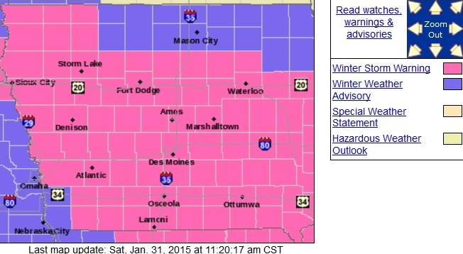
Counties in pink are in a Winter Storm Warning. Purple indicates Winter Weather Advisory.
Winds will turn to the northeast early Sunday morning at 10-to 20-mph and gust to near 30-mph by Sunday afternoon. Roads are expected to become snow covered and hazardous. Blowing snow Sunday will reduce visibility and make it difficult for state and county road crews to keep the roads clear. Travel on in the event of an emergency. If you must travel, keep an extra flashlight, food and water in your vehicle in case you become stranded.
The rain-snow mix has changed over to all snow in western Iowa as of mid-day, Saturday. Heavy snow is possible overnight, with some additional light accumulation on Sunday. In addition to the WINTER STORM WARNING, a Winter Weather Advisory is in effect for far southwest Iowa from 9-p.m. Saturday until 6-pm Sunday for Fremont and Mills Counties.

